Pascola, Missouri facts for kids
Quick facts for kids
Pascola, Missouri
|
|
|---|---|
|
Village
|
|

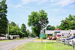
State Highway B entering Pascola
|
|

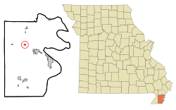
Location of Pascola, Missouri
|
|
| Country | United States |
| State | Missouri |
| County | Pemiscot |
| Area | |
| • Total | 0.16 sq mi (0.41 km2) |
| • Land | 0.16 sq mi (0.41 km2) |
| • Water | 0.00 sq mi (0.00 km2) |
| Elevation | 266 ft (81 m) |
| Population
(2020)
|
|
| • Total | 87 |
| • Density | 543.75/sq mi (210.20/km2) |
| Time zone | UTC-6 (Central (CST)) |
| • Summer (DST) | UTC-5 (CDT) |
| ZIP code |
63871
|
| Area code(s) | 573 |
| FIPS code | 29-56432 |
| GNIS feature ID | 2399629 |
Pascola is a small village located in Pemiscot County, Missouri, in the United States. In 2010, about 108 people lived there. By 2020, the population was 87.
Contents
The Story of Pascola
Pascola was officially planned and marked out in 1894. This happened when the railroad tracks were built to reach that area. People aren't sure why the name "Pascola" was chosen for this village. The local post office in Pascola closed its doors in 1992.
Where is Pascola?
Pascola is located northwest of Hayti. You can find it where two roads meet: State Route B and County State Route K.
State Route B connects Pascola to other towns like Homestown and Wardell to the north. It also links to U.S. Route 412 to the south. County State Route K connects the village with Bragg City to the west.
The United States Census Bureau says that Pascola covers a total area of about 0.16 square miles (0.41 square kilometers). All of this area is land, with no water.
People of Pascola
| Historical population | |||
|---|---|---|---|
| Census | Pop. | %± | |
| 1920 | 441 | — | |
| 1930 | 262 | −40.6% | |
| 1940 | 345 | 31.7% | |
| 1950 | 242 | −29.9% | |
| 1960 | 228 | −5.8% | |
| 1970 | 180 | −21.1% | |
| 1980 | 211 | 17.2% | |
| 1990 | 120 | −43.1% | |
| 2000 | 138 | 15.0% | |
| 2010 | 108 | −21.7% | |
| 2020 | 87 | −19.4% | |
| U.S. Decennial Census | |||
Pascola's Population in 2010
According to the census from 2010, there were 108 people living in Pascola. These people lived in 48 different homes, and 26 of those were families.
The village had about 675 people per square mile (260 people per square kilometer). There were 55 housing units, which are places where people can live.
Most of the people in Pascola (about 97.22%) were White. A small number (0.93%) were from other races, and 1.85% were from two or more races. About 0.93% of the population were Hispanic or Latino.
Homes and Families
Out of the 48 homes in Pascola:
- 25% had children under 18 living there.
- 35.4% were married couples living together.
- 12.5% had a female head of the household with no husband present.
- 6.3% had a male head of the household with no wife present.
- 45.8% were not families (meaning people living alone or with roommates).
About 29.2% of all homes were made up of just one person. Also, 14.6% of homes had someone living alone who was 65 years old or older. On average, there were 2.25 people in each home and 2.69 people in each family.
Age and Gender
The average age of people in Pascola was 43 years old.
- 17.6% of residents were under 18 years old.
- 9.3% were between 18 and 24 years old.
- 26% were between 25 and 44 years old.
- 27.8% were between 45 and 64 years old.
- 19.4% were 65 years old or older.
When it came to gender, 45.4% of the people in Pascola were male, and 54.6% were female.
See also
 In Spanish: Pascola para niños
 | Delilah Pierce |
 | Gordon Parks |
 | Augusta Savage |
 | Charles Ethan Porter |

