
Paysandú Department facts for kids
Quick facts for kids
Paysandú
|
|||
|---|---|---|---|

Old custom office in the old port in Paysandú.
|
|||
|
|||

Location of Paysandú, in red, in Uruguay
|
|||
| Country | |||
| Creation | 27 January 1816 | ||
| Capital | Paysandú | ||
| Area | |||
| • Total | 13,922 km2 (5,375 sq mi) | ||
| Population
(2011)
|
|||
| • Total | 113,124 | ||
| • Density | 8.1256/km2 (21.0451/sq mi) | ||
| Time zone | UTC-03 (UYT) | ||
| ISO 3166 code | UY-PA | ||
| Website | Official website: http://www.paysandu.gub.uy/ | ||


The Paysandú department (Spanish: Departamento de Paysandú) is like a state or province in Uruguay. Its capital city is also called Paysandú. This department was created on January 27, 1816. Its special code, used for identifying regions, is UY-PA.
Contents
Geography of Paysandú

The Paysandú department is located in the western part of Uruguay. It sits along the Uruguay River. This river forms the border with Argentina.
Paysandú covers an area of 13,922 km2 (5,375 sq mi). This makes it the third largest department in Uruguay. Only the Tacuarembó and Salto departments are bigger.
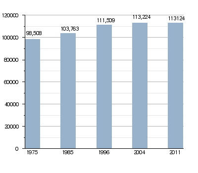
In 2011, about 113,124 people lived here. This means there are about 8.1 people per square kilometer.
Hills and Protected Areas
The department has two chains of low, rounded hills. In Uruguay, these are called cuchillas. The cuchilla de Queguay is in the northwest. The cuchilla de Haedo is in the southeast.
There is also a special protected area here. It's called Montes del Queguay (Spanish: Área protegida Montes del Queguay). This area is where the Queguay Grande and Queguay Chico rivers meet.
Where is Paysandú Located?
 |
Salto department | |
||
| Argentina | Tacuarembó department | |||
| Río Negro department |
Rivers of Paysandú
The two most important rivers in the department are:
- The Uruguay River: This river is on the western side. It forms the natural border with Argentina.
- The Queguay Grande River: This river flows from east to west through the department. It eventually joins the Uruguay River.
Climate in Paysandú
Paysandú has a "Humid subtropical climate". This type of climate is known as Cfa in the Köppen climate classification system.
On average, Paysandú gets about 1,196.3 mm (47.1 in) of rain each year. March is usually the wettest month. It gets about 142.2 mm (5.6 in) of rain. May is the driest month, with only about 66 mm (2.6 in) of rain.
The average temperature for the whole year is 17.9 °C (64.2 °F). January is the warmest month. The average temperature then is 24.8 °C (76.6 °F). June is the coolest month. Its average temperature is 11.7 °C (53.1 °F).
People of Paysandú
People who live in the Paysandú department, and especially in the city of Paysandú, are called Sanduceros in Spanish.
Population Changes Over Time
Evolution of the population in Paysandú
Rural Population
The 2011 census showed that 4,364 people lived in the rural parts of Paysandú. These are areas outside of the main towns and cities.
Main Towns and Cities
Here are the largest towns and cities in the Paysandú department, based on the 2011 population count:
| City / Town | Population (2011) |
|---|---|
| Paysandú | 76,412 |
| Nuevo Paysandú | 8,578 |
| Guichón | 5,039 |
| Chacras de Paysandú | 3,965 |
| Quebracho | 2,853 |
| San Félix | 1,718 |
| Porvenir | 1,159 |
| Tambores | 1,111 |
| Piedras Coloradas | 1,094 |
Gallery
-
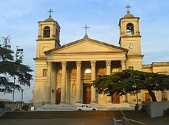
Basilica of Paysandú.
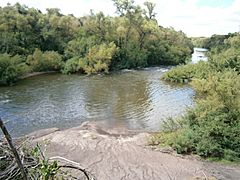
-
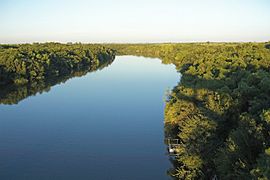
Queguay Grande river.
-
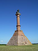
Plateau of Artigas.
-
Montes del Queguay.


Related pages
See also
 In Spanish: Departamento de Paysandú para niños
