
Pedra Branca, Singapore facts for kids
.jpg)
Detail of a 1620 "Map of Sumatra" by Hessel Gerritz, a cartographer with the Hydrographic Service of the Dutch East India Company. The location of the island of "Pedrablanca" (Pedra Branca) is marked.
|
|
| Geography | |
|---|---|
| Location | South China Sea |
| Coordinates | 1°19′49″N 104°24′21″E / 1.330368°N 104.405883°E |
| Area | 8,560 m2 (92,100 sq ft) |
| Length | 137 m (449 ft) |
| Width | 60 m (200 ft) (average) |
| Administration | |
Pedra Branca is a tiny island located at the western edge of the South China Sea. It's also known as Pulau Batu Puteh or Batu Puteh. This small island sits at the eastern entrance of the Straits of Singapore and is the easternmost point of Singapore.
Contents
History of Pedra Branca
Building Horsburgh Lighthouse
A very important building on Pedra Branca is the Horsburgh Lighthouse. This lighthouse was built between 1847 and 1851. Lighthouses help ships find their way safely at sea, especially at night or in bad weather.
A Long-Standing Island Dispute
For many years, Pedra Branca was the subject of a disagreement. Both Malaysia and Singapore believed the island belonged to them. This kind of disagreement between countries is called a territorial dispute.
The International Court of Justice's Decision
To solve the dispute, Malaysia and Singapore took their case to the International Court of Justice (ICJ). The ICJ is the main court of the United Nations. It helps countries settle their legal disagreements peacefully. In 2008, the ICJ made a final decision. The court ruled that Pedra Branca is part of Singapore. This decision helped to resolve the long-standing issue between the two nations.
Images for kids
-
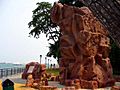
A replica of Long Ya Men at the Labrador Nature Reserve, put up in 2005 as part of the Singapore Zheng He's 600th Anniversary Celebrations
-
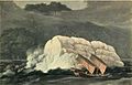
Thomas and William Daniell's etching of Pedra Branca before the building of Horsburgh Lighthouse, c. 1820
-
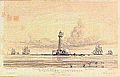
Horsburgh Lighthouse, a painting by John Turnbull Thomson (1821–1884) showing the island of Pedra Branca just after the completion of the lighthouse in 1851, which he designed.
-
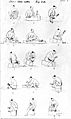
A sketch by Thomson showing Chinese stonecutters from the "Kay tribe" (that is, of Hakka origin) at work in a quarry on Pulau Ubin, an island off the northeast coast of Singapore, which supplied granite for the lighthouse on Pedra Branca.
-
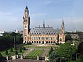
The Peace Palace in The Hague, Netherlands, the seat of the International Court of Justice


See also
 In Spanish: Pedra Branca para niños
