
Pike Hill Signal Tower facts for kids
Quick facts for kids Pike Hill Signal Tower |
|
|---|---|
| Cumbria, England, UK | |

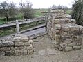
The remains of Pike Hill Signal Tower
|
|

Pike Hill Signal Tower
Location in Cumbria
|
|
| Coordinates | 54°58′33″N 2°39′47″W / 54.975955°N 2.662937°W |
The Pike Hill Signal Tower was a special lookout post built by the Romans. It stood on a high hill in northern Britannia (which is now England). This tower was one of many signal stations.
These towers were built in the early 100s AD. They watched over a Roman road called the Stanegate. Later, the Pike Hill tower became part of Hadrian's Wall. Today, only a small piece of its wall remains. It is about 2 meters (6.5 feet) long. You can find it in Cumbria, United Kingdom. The tower is located near other Roman sites like Turret 51B and Turret 52A. The Roman fort of Banna is also nearby to the east.
Contents
History of the Signal Tower
A long time ago, around 100 AD, the Roman army left Scotland. They then built a strong border in northern Britain. This border included forts and signal towers along the Stanegate road. This road connected important Roman forts like Corbridge and Carlisle.
The Pike Hill tower was part of this early border system. Its main job was to send signals. It could send messages to two other nearby signal stations. These were called Gillalees Beacon and Barrock Fell.
Later, around 125 AD, the Romans started building Hadrian's Wall. This huge wall was built to protect the Roman Empire. When the wall reached Pike Hill, the signal tower became part of it. The tower was about 200 meters (656 feet) east of Turret 52A. It was also west of Leahill Turret (Turret 51B).
Some historians think soldiers from Milecastle 52 guarded the signal tower. Milecastle 52 was a small fort on Hadrian's Wall. It was about 20% bigger than other milecastles. This extra size might mean it had more soldiers to also man the tower.
How the Tower Was Built
Experts have studied the tower's remains. They found that the signal tower was built before Hadrian's Wall. It was also built before the turf or stone walls nearby.
The tower was not perfectly lined up with the wall. It stood at a 45-degree angle to the wall's path. This special angle helped the tower's signals be seen better. There was also a ditch north of the tower. It followed the same zig-zag path as the tower.
The signal tower was a square building. Each side measured about 6 meters (20 feet) long. It was built on a strong base of stones and mortar. Deep foundations were found, showing the tower was quite tall. The stone work was very good quality. It was even better than the stone work on the smaller turrets along Hadrian's Wall.
Discoveries and Investigations
People have studied the Pike Hill Signal Tower for many years. Here are some important discoveries:
- 1931 - The tower's remains were dug up and made stronger. This is called excavation and consolidation. During this work, they found pieces of pottery. These pots were from the time of Emperor Hadrian. They also found rims of cooking pots called Huntcliff ware. These pots show that people lived at the tower until the late 300s AD.
- 1971 - English Heritage did another study of the site. They noted that a modern road had been built. This road had destroyed most of the tower. Only a small part of the south-east wall was still visible.
Images for kids
-
The remains of Pike Hill Signal Tower
