
Porcher Island facts for kids
|
Native name:
K’paal
|
|
|---|---|

Oval Bay, Porcher Island
|
|

Porcher Island (British Columbia, Canada)
|
|
| Geography | |
| Location | Hecate Strait |
| Coordinates | 53°59′02″N 130°31′29″W / 53.98389°N 130.52472°W |
| Area | 200 sq mi (520 km2) |
| Coastline | 100 mi (200 km) |
| Administration | |
|
Canada
|
|
| Province | British Columbia |
| Land District | Coast Land District, Range 5 |
| Regional District | Skeena-Queen Charlotte Regional District |
| Demographics | |
| Population | 37 (2006) |
| Pop. density | 0.071 /km2 (0.184 /sq mi) |
Porcher Island is a large island located in Hecate Strait, British Columbia, Canada. It is found near the mouth of the Skeena River, southwest of the city of Prince Rupert. A small community, also called Porcher Island, is located at the northern tip of the island in Humpback Bay. Nearby islands include Stephens Island and Prescott Island, which are just off its northwestern side.
Contents
Where is Porcher Island Located?
Porcher Island is the eighth largest coastal island in British Columbia. It covers about 518 square kilometers (200 square miles). The northern tip of the island is about 24 kilometers (15 miles) southwest of Prince Rupert. It is also about 70 kilometers (43 miles) south of the very bottom part of Southeast Alaska.
The island is part of the North Coast Regional District. It is surrounded by different bodies of water. To the north, you'll find Chatham Sound and the Skeena River estuary. Hecate Strait is to the west, and Ogden Channel is to the east. South of Porcher Island, Metlakata Inlet and Kitkatla Channel separate it from other islands like Goschen, Dolphin, and Spicer Islands.
What are the Island's Features?
Porcher Island has a long, narrow channel called Porcher Inlet that cuts deep into its southern part. This inlet stretches for about 13.7 kilometers (8.5 miles) and ends in a salty lagoon. On the western side of the island, there is a beautiful sandy beach at Oval Bay. This beach is about 5 kilometers (3 miles) long and faces the strong winds that often blow through Hecate Strait.
The inside of the island is quite hilly. Egeria Mountain, located southeast of Porcher Inlet, is the tallest point, reaching about 888 meters (2,915 feet) high. The Bell Range is another important group of hills in the northwest.
A Brief History of Porcher Island
Porcher Island is part of the traditional lands of the Gitxaala Nation. The island was named after Edwin Augustus Porcher, a commander in the Royal Navy. He served on HMS Sparrowhawk from 1865 to 1868. During his time, Commander Porcher explored the North Coast of British Columbia several times. His ship would have sailed close to the island that now carries his name.
For most of its history, Porcher Island has not had many people living on it. Even when Prince Rupert became a major railway stop in 1906, only a few new settlers arrived. The island's remote location, along with its wet, cool summers and harsh winters, made it a difficult place to live permanently.
However, three small communities were started in the 20th century, and some people still live there today. These settlements are Hunts Inlet, Humpback Bay (both at the northern tip), and Oona River (on the eastern side).
Communities on Porcher Island
- Hunts Inlet: This area has older buildings and a government dock. Many people from Prince Rupert now have vacation homes here.
- Humpback Bay: This was once the site of the Porcher Island Cannery, which processed salmon. The cannery was built in 1928 but only operated for four years. Later, it was used as a summer base for gillnet fishing boats until 1968. Today, the cannery buildings are no longer in use.

- Oona River: This is the largest community on Porcher Island, with about 30 permanent residents. It was first settled by Scandinavian immigrants around the time of the First World War. Oona River became known for building wooden boats for the B.C. salmon fishing industry. Many strong, handmade boats were built here from local cedar. Some of these boats are still used today. The Oona River Salmon Enhancement Project also works to help increase the number of coho salmon in the area.
In 2006, the island and its surrounding areas had a population of 37 people. This number was lower than in 2001.
Wildlife and Nature on Porcher Island
Porcher Island is part of a unique natural area called the Hecate Lowland Ecosection. This area has narrow lowland rainforests and many coastal islands. The land is often rough and rocky, with large areas of muskeg (a type of wetland) and bog forests.
Plants of Porcher Island
Common trees found here include western red cedar, yellow cedar, mountain hemlock, and fir trees. Below the trees, you can often see plants like Salal, ferns, and skunk cabbage. The weather on Porcher Island is often windy with heavy rainfall.

Birds and Marine Life
Many different types of waterfowl (birds that live near water) live in the protected inlets and estuaries along Porcher Island's 160-kilometer (100-mile) coastline. Some of these birds include Merganser, Surfbird, Marbled Murrelet, Glaucous-winged gull, Northwest heron, Red-Throated Loon, Rhinoceros auklet, Greater white-fronted goose, and Northern bald eagle.
Both Chatham Sound and Kitkatla Channel provide important places for many seabirds to breed and nest. These areas are also vital stops along the Pacific coast for birds that migrate (travel long distances).
Images for kids
-
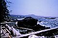
Oval Bay, Porcher Island
-
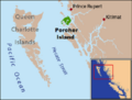
Porcher Island (British Columbia, Canada)
-
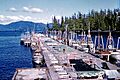
Gillnet Floats, Humpback Bay, Porcher Island, 1964
-
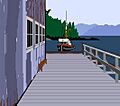
Porcher Island Cannery
See also
 In Spanish: Isla Porcher para niños
