Porter Brook facts for kids
Quick facts for kids Porter Brook |
|
|---|---|

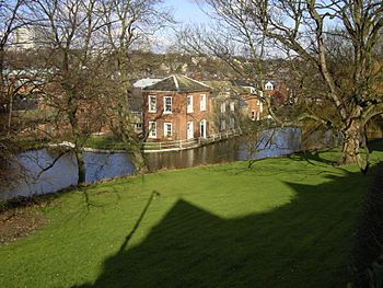
The Porter Brook at Wilson's Sharrow Mill.
|
|
| Country | England |
| Physical characteristics | |
| Main source | Pennines |
| Length | 6.5 mi (10.5 km) |
The Porter Brook is a river that flows through the city of Sheffield, England. It starts high up on Burbage Moor and flows over 1,000 feet (300 m) down to join the River Sheaf. This happens underground, near Sheffield railway station.
Like other rivers in Sheffield, the Porter Brook drops steeply. This made it perfect for powering water mills. These mills were used for metalworking and making cutlery. Over the years, about 20 dams were built along the river to help these industries.
Today, much of the lower part of the river flows through underground tunnels called culverts. But some parts are being opened up again. This project is called "daylighting" and helps bring the river back into the open.
| Top - 0-9 A B C D E F G H I J K L M N O P Q R S T U V W X Y Z |
River's Journey: From Moor to City
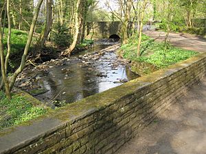
The Porter Brook begins from springs on Burbage Moor. The highest spring is near the 370-metre (1,210 ft) mark. Its source is inside the Peak District National Park, close to Ringinglow village.
The river flows through Clough Hollow and under Fulwood Lane. Here, it leaves the National Park. Nearby, you can find Finder Cairn, a special table that points to local landmarks. Soon, the Porter Brook meets Mayfield Brook. Mayfield Brook used to power Fulwood corn mill, the highest mill on the river system.
After this, the combined river reaches Forge Dam. This is now a large lake with an island. In Sheffield, a "dam" means the body of water itself, not the wall that holds it back. Mills used for grinding were called "wheels." The channel that carried water away from a mill was known as a "goit."
Beyond Forge Dam, the Porter Brook flows past Wire Mill Dam. Here, you can see a monument to Thomas Boulsover. He invented Sheffield Plate, a special way to make silver-plated items.
The river then goes under Whiteley Wood Road bridge. A small stream from Porter Valley Woodlands Nature Reserve joins it here. Next, it reaches Hangingwater Road bridge. This is a large bridge built around 1800. Right below the bridge is the dam for Shepherd's Wheel. The buildings and machinery at Shepherd's Wheel are very old and still work! It is now a museum.
The river continues through Whiteley Woods. It passes Ibbotson dam and goes under Oakbrook Road. Then it reaches Nether Spurgear dam. Oak Brook joins the river from the north. Holme dam is also near the river as it enters Endcliffe Wood.
Most of the river from Fulwood Lane is part of the Porter Valley Parks. These are green spaces and parks created along the river valley between 1885 and 1938. Sheffield Corporation bought land in Endcliffe Woods in 1885 to make public walks. They also wanted to build a sewer because sewage was flowing into the river.
They asked William Goldring to design a park. It had paths, flower beds, bridges, and places to sit. Some dams were used for new purposes. Endcliffe dam was for bathing, Holme dam for skating, and Nether Spurgear dam for wildfowl. In 1924, the Porter Valley parks were called "the finest example" of a park leading from a city into the countryside.
At the end of Endcliffe Park, the river goes under Brocco Bank road. This is near the roundabout on Eccleshall Road. Eccleshall Road became a toll road in 1810. A toll gate from that time is still there, though it was moved in the early 1900s.
Beyond Brocco Bank, a small bridge built in 1899 crosses the river. It leads to the George Woofindin almshouses. The river then goes into an underground section. It comes out on the south side of Eccleshall Road. It winds through houses to reach Sharrow Vale dam and snuff mill. The main mill building is from 1737. A newer building from 1880 still has its original machinery. A bridge from the late 1700s is also at the end of the buildings.
The river then runs next to Ecclesall Road and the Sheffield General Cemetery. The cemetery's main entrance, built in 1836, is on a long bridge over the river. After going under Pear Street and Summerfield Street, the river enters an area that was once Ward's Brewery. It is now housing, but the old entrance arch remains.
The river then goes into the Waitrose culvert, flowing under Harrow Street and a supermarket. It appears again near the Baan Thai Restaurant. Then the St Marys Gate culvert takes it under London Road and the A61. There's a short open part by the Theatre Deli car park. The Eyre Street culvert then goes under Eyre Street and a sports shop.
The river comes out again on the north side of Mary Street. It flows under Matilda Street Bridge, through the new Matilda Street Pocket Park, and behind the BBC offices. Then it enters the Shoreham Street culvert. It briefly appears behind Sheffield Station car park. Finally, it enters the station culvert. This culvert joins the one carrying the River Sheaf under the station platforms. The two rivers meet under platform 5A. The Sheaf & Porter Rivers Trust hopes to let people see this spot.
The Porter Brook gets its name from its brownish color. This color is like "Porter" beer. It comes from the river flowing over iron-ore deposits.
River Changes: Past and Present
People have changed the river a lot over hundreds of years. They built dams to hold water for mills and metalworking. Shepherd's Wheel was mentioned as early as 1566. By 1780, there were 20 mills along the river. Weirs (small dams) were built without thinking about the river's plants and animals.
Many parts of the Porter Brook flow through underground tunnels as it reaches the city. For example, the river near Matilda Street was moved into a new, straight channel between 1797 and 1808. By 1853, parts of the river were put into culverts. This allowed houses and factories to be built on top. More sections were culverted by 1891 as industries grew.
Sheffield station opened in 1870. It was built over an area called Sheaf Island. The River Sheaf was on one side, and the Porter Brook was on the other. Both rivers were moved in the late 1700s. The Midland Railway bought the water rights in 1868. Both rivers were put into culverts so the station could be built.
The Porter Brook can flood in the city. This is because it's squeezed into narrow channels and culverts that are too small for heavy rain. In 2008, Sheffield started looking into "daylighting" rivers. This means opening up culverted rivers.
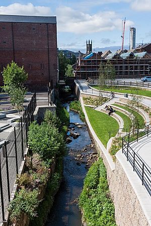
In 2011, they started two daylighting projects on the Porter Brook. One was in a rural area, and the other was in the city at Matilda Street. The rural project was finished by 2013. The Matilda Street project took longer, finishing in 2016.
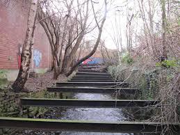
The Matilda Street project created a "pocket park." Before, the river was in a narrow channel with steel beams over it. The area next to it was overgrown and used for parking. Now, there's a semi-circular area leading down to the river. The river itself was made more natural. This park helps the city by providing green space. It also helps with flooding. When it rains heavily, the park is designed to flood. This slows down the water before it reaches areas further downstream.
The project won an award in 2016. The pocket park only covers a short part of the river. But the council wants to extend these improvements. They also plan to create a walking and cycling path along the river.
In 2004-2005, major work happened at Endcliffe Park. This helped reduce sewage overflows and flooding. In 2014, Sheffield City Council announced plans for a flood prevention project. It would create floodwater storage areas at Mayfield, Whiteley Woods, and Endcliffe Park. Walls would also be built along parts of the river. This large project started in 2015.
Water Power: Sheffield's History
The Porter Brook was perfect for water power. The last part of the river drops about 450 feet (140 m) in just over 4 miles (6.4 km). This meant dams could be built close together. The water flowing out of one mill wouldn't block the next one. Also, natural sandstone was easy to find in the nearby hills.
By 1740, Sheffield used more water power than any other place in Britain, and maybe even Europe. Ninety mills had been built, mostly for grinding. By 1850, there were over 100 mills. In the Porter valley alone, 21 dams powered 19 water-wheels. These were used for grinding corn, operating forge-hammers, rolling metal, and grinding knives and blades. This is what made Sheffield famous. Most of these mills were busy during the 1700s and 1800s.
Here are some of the important mills along the Porter Brook:
- Fulwood Cornmill
A mill existed here in 1641. It was used to grind corn. Later, Thomas Boulsover used it to make Sheffield-plate buttons. The mill stopped being used by 1884. The dam for this mill has completely filled up with silt.
- Forge Dam (still exists)
Thomas Boulsover first tried to make paper here, but the water wasn't good enough. By 1765, it was a forge and rolling mill. It was used to make saws and beat hot metal. The mill stopped working around 1887. Later, the dam was used for boating. The workers' cottages became a café.
- Wiremill Dam (still exists)
This mill made thin steel plates for saws and wire for the cutlery industry. Wiremill Dam once had the largest water-wheel in Sheffield.
- Shepherd Wheel (still exists)
This mill was first mentioned in 1566. It was leased to Edward Shepherd in 1749, and that's how it got its name. The Hind family worked here until about 1930. The mill is now a museum run by the Sheffield Industrial Museums Trust. You can still see the machinery working!
- Ibbotson's Wheel (still exists)
This mill was built in 1754. It became known as Ibbotson's Wheel from 1775. In 1847, unknown people broke five of its grindstones. The mill was demolished around 1950. In the early 1900s, the dam became Porter Glen Boating Lake.
- Holme Wheel (still exists)
The dam here became Endcliffe Boating Lake when Endcliffe Park reopened in 1887. This was to celebrate Queen Victoria's Jubilee.
- First Endcliffe Wheel
This dam at Hunter's Bar became Endcliffe Bathing Pool for a short time. It closed when World War II started. About 20 years later, it was drained and filled in.
- Upper Lescar Wheel and Nether Lescar Wheel Dam
These mills were named after a marshy area called Leeche Carr. "Carr" means a wetland turning into a forest. Records show these mills existed in 1587. They supplied power to the Porter Steel Works until 1890. Both Lescar Wheels and Porter Works Dams were drained to build houses.
- Sharrow Mills
Sharrow Wheel was used by cutlers by 1604. In the 1740s, Joseph Wilson made the wheel bigger. A snuff mill was built here in 1763. The Wilson family has run the mill ever since. The water-powered snuff grinding equipment is still there, but it's not used for business anymore.
- Stalker Wheel
This mill was located between Ecclesall Road and the stone wall of Sheffield General Cemetery.
- Sharrow Forge
This mill was drained and filled in around 1870. Houses and a primary school were built on the land.
- Broomhall Cornmill
This mill was also drained and filled in around 1870.
- Bennett's Wheel
The original grinding wheel closed in 1851. The dam was then used by the Vulcan Works, a forge and rolling-mill.
- Leadmill Dam
A White Lead Works was built here in 1759. It made pigments for paint and pottery. When it closed, the dam was filled in. A tram-depot was built on the site around 1910.
The Peak Park Anniversary Cycle Route follows the Porter Brook from Bingham Park to Porter Clough.
River Health: Water Quality
The Environment Agency checks the water quality of rivers in England. They give each river an overall "ecological status." This can be high, good, moderate, poor, or bad. They look at things like the types of invertebrates (bugs), plants, and fish in the river. They also check the "chemical status" by looking at chemicals in the water. Chemical status is either good or fail.
The Porter Brook is called "heavily modified." This means people have changed its channels a lot.
Here's how the Porter Brook's water quality was in 2019:
| Section | Ecological Status | Chemical Status | Overall Status | Length | Catchment | Channel |
|---|---|---|---|---|---|---|
| Porter from Source to River Sheaf | Moderate | Fail | Moderate | 4.8 miles (7.7 km) | 6.59 square miles (17.1 km2) | heavily modified |
The water quality has gotten worse since 2009. Back then, it was rated "good" for both ecological and overall status. In 2019, its chemical status changed to "fail." This was because new chemicals like PBDE, PFOS, and mercury were included in the checks.
Sheaf & Porter Rivers Trust: Helping the Rivers
The Sheaf & Porter Rivers Trust is a group of volunteers. They want to make people more aware of the Porter Brook and River Sheaf. They also work to help these rivers become healthier. The Trust started on May 15, 2019.
This group continues a long history of efforts to improve Sheffield's rivers. For example, Sheffield Corporation started creating parks along the upper Porter Brook in 1885. The Five Weirs Walk Trust also worked to open up access to the River Don in the 1980s.
The Trust believes that improving the lower parts of the Sheaf and Porter rivers will help nature. It will also improve the health and happiness of people living in the city. When the Trust started, there were many new building projects along the lower Porter. This gave them a chance to open up the river and create public spaces.
For example, they convinced Decathlon Sportswear not to replace a culvert roof that had collapsed into the river. Now, the exposed river can be made more natural. They are also working with the BBC. The river runs under the BBC car park, and it was so overgrown that the owners didn't even know it was there! The Trust plans to cut back the plants to let light reach the river.
The Trust also wants to create a larger park where the Porter and Sheaf rivers meet the River Don. The final culvert they flow through is old and needs to be fixed or removed. The Trust wants it removed and is trying to get money for this. They also want to add "light wells" to other culverts. This would help wildlife move through them to reach the upper parts of the rivers. They hope that new rail projects, like HS2, could help make this happen. The Trust also wants to make sure there's a continuous path along the river.
Points of Interest Along the River
| Point | Coordinates (Links to map resources) |
OS Grid Ref | Notes |
|---|---|---|---|
| Junction with River Don | 53°23′07″N 1°27′44″W / 53.3853°N 1.4622°W | SK358877 | by Blonk Street bridge |
| Start of Sheffield Station culvert | 53°22′38″N 1°27′48″W / 53.3771°N 1.4632°W | SK358868 | |
| Porter Brook daylighting scheme | 53°22′32″N 1°28′04″W / 53.3756°N 1.4679°W | SK354866 | |
| Start of St Mary's Gate culvert | 53°22′21″N 1°28′54″W / 53.3725°N 1.4818°W | SK345863 | |
| Sharrow Snuff Mill | 53°22′07″N 1°29′35″W / 53.3685°N 1.4930°W | SK338858 | |
| A625 Ecclesall Road bridge | 53°22′07″N 1°29′56″W / 53.3685°N 1.4990°W | SK334858 | |
| Oakbrook Road bridge | 53°22′07″N 1°31′14″W / 53.3685°N 1.5205°W | SK320858 | |
| Fulwood Lane bridge | 53°21′12″N 1°34′27″W / 53.3532°N 1.5742°W | SK284841 | |
| Clough Hollow | 53°21′11″N 1°34′41″W / 53.3530°N 1.5780°W | SK281840 | source |
 | James Van Der Zee |
 | Alma Thomas |
 | Ellis Wilson |
 | Margaret Taylor-Burroughs |


