Potrero Hills (Richmond, California) facts for kids
Quick facts for kids Potrero Hills |
|
|---|---|
| Potrero Ridge, Point Molate Hills | |

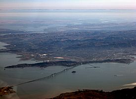
Potrero Hills refers to the hills forming the western shore to the left and right of the bridge.
|
|
| Highest point | |
| Peak | Unnamed |
| Elevation | 494 ft (151 m) |
| Geography | |
| Country | United States |
| Range coordinates | 37°57′05″N 122°24′33″W / 37.95127°N 122.40928°W |
| Parent range | Berkeley Hills |
| Geology | |
| Age of rock | Precambrian and Cretaceous |
| Type of rock | shale, sandstone, chert |
The Potrero Hills are also called the Potrero Ridge or Point Molate Hills. They are a range of hills with steep slopes, covered in chaparral plants and forests. These hills run from the northwest to the southeast along the San Pablo Peninsula in Richmond, California.
Contents
About the Potrero Hills
These steep hills stretch from Point Richmond in the south to Point San Pablo in the north. They were formed by the powerful forces of the San Pablo Fault. This fault is a smaller part of the larger Hayward Fault.
How the Hills Were Formed
Long ago, these hills were part of an island. This island was located off the coast of what is now central Richmond. Over time, the area around the island was filled in with land. This is similar to how Bay Farm Island in Alameda was formed. The rocks that make up the Potrero Hills are shale, sandstone, and chert. These are all types of sedimentary rocks.
Peaks and Past Uses
The Potrero Hills have two main peaks. The tallest one is about 494 feet (151 meters) high. The second tallest is about 328 feet (100 meters) high. Neither of these peaks has a specific name. In the past, parts of these hills were used for growing grapes. These grapes were for the Winehaven Winery. At one time, this was the largest winery in the world! Some areas were also used for grazing goats. People also dug for rocks in a place called the Blake Brothers Quarry.
What the Hills are Used For Today
The Potrero Hills act like a natural wall. They help protect the Point Molate area. This protection is important in case harmful chemicals are released. These chemicals could come from the nearby Chevron Richmond Refinery.
Transportation and Features
A road called Interstate 580 cuts through the southern part of the hills. This road creates a pass for cars to travel through. A weather station sits on top of one of the peaks. It looks out over Point San Pablo. Near the south end of the hills is a small lake called Point Potrero Pond. It is close to the Richmond–San Rafael Bridge toll plaza.
Plants and Environment
The hills have different types of plants. You can find eucalyptus woodlands, chaparral plants, and grasslands. There are also some wetlands, which are areas where the ground is wet. Some parts of the hills used to be places where fuel was stored. These areas are now being cleaned up.
 | Roy Wilkins |
 | John Lewis |
 | Linda Carol Brown |

