
Precolonial Saba facts for kids
The small Caribbean island of Saba might be tiny, only about 13 square kilometers, but it has a huge history! Archaeologists, especially from Leiden University, have found many clues showing that Saba was a very important part of the island network in the Caribbean long before Europeans arrived.
Imagine finding ancient tools and pottery from other islands like Antigua and St. Martin on Saba. This tells us that the people living on Saba weren't alone. They traded and connected with communities all over the Caribbean. Scientists have found many ancient sites on Saba, some dating back to around 1875 BC, all the way up to when Europeans first came to the island.

Contents
Saba's Unique Landscape
Saba is part of the Leeward Islands in the Lesser Antilles. It's one of the smallest islands, shaped a bit like a squashed triangle. The island's center is dominated by its highest point, Mount Scenery, which is about 870 meters tall.
Because Saba is so mountainous, there are hardly any flat areas. This made it tough for ancient people to grow crops or build houses. It was also hard to find good spots to land boats. This might have made things tricky for ancient fishers and traders.
Saba gets more rain than other islands because of its tall mountains. Its climate is quite similar to parts of South America. The year has three main weather periods:
- Dry period: From January to May, with less rain.
- Intermediate period: From May to September, with moderate rain.
- Wet season: The last few months of the year, with lots of rain.
The temperature near the sea is usually around 25 degrees Celsius.
Saba's Ancient History
The climate in the Caribbean changed a lot in ancient times. There were periods of drought (very little rain) and many hurricanes. Then came more humid (wet) times. These changes affected how people lived.
Archaeologists have found three main types of ancient settlements on Saba:
- Inland Settlements: These were high up, between 140 and 400 meters. Many were on saddles (low points between hills) near Mount Scenery. These spots were great for seeing the sea and offered protection from other groups.
- Coastal Settlements: Found near the sea, often at the end of a ravine or in a basin. These areas were small, so they might have been used for special activities, like landing canoes, rather than for living. Saba has very few places to land boats, so these ravines were important.
- Mountain Settlements: Small sites in the hills, probably used as seasonal shelters. Many isolated stone tools have been found here.
The first people likely arrived on Saba around 1875 BC. They probably came from South America, using their amazing navigation skills to cross the sea to the Lesser Antilles.
Over 20 ancient sites have been found on Saba. The main period of settlement was between AD 400 and 1450. During this time, the people of Saba were farmers, growing root crops and getting food from the sea. They made pottery, tools, and sculptures from stone, shells, animal bones, and coral.
Important Ancient Sites on Saba
Plum Piece
Plum Piece is one of the oldest known ancient sites on Saba, dating back to around 1875–1520 BC. It's in the northwest of the island, about 400 meters above sea level, not near the coast. From Plum Piece, you can see the cliffs at Mary's Point and the ocean.
In 2001, archaeologists found many pieces of flint, stone, and shell tools here. They also found shallow postholes, which are holes where wooden posts for shelters would have stood. This suggests the site was used as a seasonal camp. People living here ate a lot of land crabs and a type of seabird called Audubon's shearwater.
Evidence shows Plum Piece was used for specific tasks, like woodworking or building canoes, especially between February and July. This time also matched when the birds nested and crabs spawned. It's thought that people visited Plum Piece and similar camps on other islands as part of a yearly cycle, moving to where resources were available.
The Bottom
The Bottom site is in the eastern part of the village called The Bottom. It's in a bowl-shaped area surrounded by Mount Scenery and lava domes, about 240 meters above sea level. This site dates from around AD 800 to 1200.
The Bottom had good soil for farming and access to tropical forest resources. Archaeologists found pottery pieces, shell and bone fragments, and stone tools here. Some of the pottery is similar to pottery found on Anguilla, showing that these islands were connected.
Spring Bay
Three ancient sites were found close together and named Spring Bay 1, 2, and 3.
- Spring Bay 1: This site was in the middle of a basin. Archaeologists found many discarded tools and food remains here, including pottery, stone, shell, coral, and bone tools. They also found ornaments like beads and amulets, and special ceremonial objects called zemis (three-pointed objects). By studying the pottery, they identified three different periods of people living here: Spring Bay 1a (AD 400–600), 1b (AD 800–1200), and 1c (AD 1300–1450). A burial of a small child was also found here.
- Spring Bay 2: This site was near Well's Gut, an area affected by sea erosion. It dates from AD 800–1200. Finds included pottery, spindle whorls (used for spinning thread), and various tools. This site was also close to a spring, suggesting it might have been used for special activities like collecting fresh water or cleaning cooking tools. It seems Spring Bay 2 was not directly connected to Spring Bay 1 and 3.
- Spring Bay 3: Found about 75 meters from Well's Gut, this site was a small area for disposing of trash. It also dates from AD 800–1200. The finds were similar to Spring Bay 1, including spindle whorls, stone tools, beads, and small zemis.
Kelbey's Ridge
Kelbey's Ridge is about 140 meters above sea level and has a flat area of about 0.9 hectares. Local people say this area is good for growing sweet potatoes and other root crops.
In 1988, Leiden University found two areas with ancient objects, named Kelbey's Ridge 1 and 2.
- Kelbey's Ridge 1: Dates from AD 400–600. Archaeologists found pottery fragments and food remains, mostly land crab shells. Other finds included stone tools and a zemi made of coral.
- Kelbey's Ridge 2: Dates from AD 1300–1500. This location gave ancient people access to many resources. They could easily get marine resources from the sea (about 300 meters away) and plants, birds, and small mammals from the nearby rainforest on the higher slopes.
At this site, archaeologists found evidence of 7 huts, each about 8.5 to 9.5 meters wide. Some huts were used for cooking, and one for storage. Four hearths (fireplaces) were found.
Seven burials, containing ten individuals, were found inside the house areas. Both inhumations (burying the body) and cremations (burning the body) happened here. Most bodies were placed in a flexed, almost seated position. Burial gifts were not common. The burials included adults and children of different ages. One unique burial involved a cremated child's skeleton placed inside an adult male's burial.
Finds from Kelbey's Ridge 2 included pottery, spindle whorls, stone tools, shell and coral objects, beads, pendants, zemis, and a snuff inhaler made from manatee bone. It seems the site was divided into several households, each with its own living area and cooking space. The site was likely occupied by four or five households at the same time for about 50 years.
Saba's Connections to Other Islands
Because Saba is so mountainous, it was hard for ancient people to create large settlements or big farms. Also, many land animals and plants found on other islands were not on Saba. This means the sea and connections with other islands were super important for Saba's ancient people.
Archaeological evidence suggests that Amerindian groups started settling smaller islands in the Lesser Antilles around 2900 BCE. Soon after, communities from different islands likely worked together to get resources, moving around based on the seasons.
For example, finding high-quality flint was a big reason for people to travel. Flinty Bay on Antigua was one of the best sources of flint in the region. Flint from Antigua has been found on most islands in the Lesser Antilles, including Saba's Plum Piece site. This shows how connected these islands were.
The need for good wood to build canoes might have also brought people to Saba. Waste from large Lobatus gigas shells (conch shells) was found at Plum Piece. These shells were probably brought from places like St. Martin and then worked on Saba. Greenstone from St. Martin, used for making axes, was also found on Saba. This makes Saba a key point for distributing both St. Martin greenstone and Antigua flint.
Studies of clay show that Saba's people used local clay but also clay from nearby islands like St. Eustatius, St. Martin, and Anguilla. The only known case of cremation in the Lesser Antilles was at Kelbey's Ridge 2 on Saba. Cremation was more common in the Greater Antilles, suggesting a connection there. Burial items from Saba, like a fish-shaped snuff inhaler, are similar to items found on both Greater and Lesser Antilles islands.
Connections between Saba and other Caribbean islands continued for centuries. Analysis of the Kelbey's Ridge 2 site shows that Saba had a central geographic position. It connected people from the Greater Antilles with those in the Leeward Islands. Saba was not just a starting point for journeys but also lay on many of the shortest travel paths across the islands. This shows Saba was a strategically important island in the Northeastern Caribbean. The finds at Kelbey's Ridge 2 confirm that even a small community in a challenging environment could be part of and influence large trade networks across the Caribbean. In the 14th century, the Northern Lesser Antilles was like a "frontier zone" where independent communities freely traded goods and services.
Images for kids
-
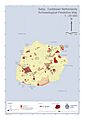
Saba Archaeological Map showing ancient sites and historical spots.
