Preston, Minnesota facts for kids
Quick facts for kids
Preston
|
|
|---|---|

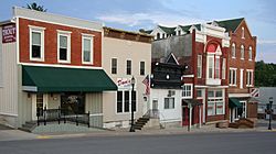
Preston Main Street commercial district
|
|
| Nickname(s):
"Minnesota's Trout Capitol"
|
|

|
|
| Country | United States |
| State | Minnesota |
| County | Fillmore |
| Area | |
| • Total | 2.46 sq mi (6.38 km2) |
| • Land | 2.46 sq mi (6.38 km2) |
| • Water | 0.00 sq mi (0.00 km2) |
| Elevation | 955 ft (291 m) |
| Population
(2020)
|
|
| • Total | 1,322 |
| • Density | 536.31/sq mi (207.11/km2) |
| Time zone | UTC-6 (Central (CST)) |
| • Summer (DST) | UTC-5 (CDT) |
| ZIP code |
55965
|
| Area code(s) | 507 |
| FIPS code | 27-52450 |
| GNIS feature ID | 2396272 |
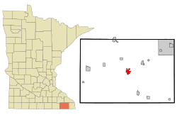
Preston is a city in Minnesota, United States. It is the main town, or county seat, of Fillmore County. In 2020, about 1,322 people lived there.
The Root River flows through Preston. The famous Mystery Cave State Park is also very close by. Preston calls itself "America's Trout Capital." You can even see a 20-foot tall trout statue along Minnesota State Highway 16!
Contents
History of Preston
Preston was first planned out in 1855. The town got its name from Luther Preston. He was a millwright (someone who builds mills) and a postmaster.
Old Grain Elevator
The old Preston grain elevator was once known as the Milwaukee Elevator Company Grain Elevator. It was built around 1890. Its job was to hold grain before it was sent by railroad to cities in the eastern United States. The elevator was last used in the 1980s.
It was built using a special "cribbed" method. This means it had strong, interlocking bins. This way of building was much stronger and more expensive back then than other methods. Today, the Preston Historical Society is working to fix up this old building.
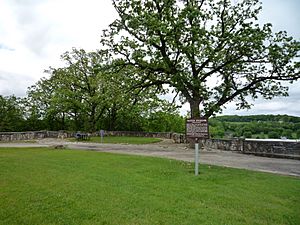
Preston Overlook
The Preston Overlook was built in 1937. It was part of a special program during the New Deal to help people find work. Workers from the Minnesota Department of Highways built it.
They chose a spot on the highest point of the bluffs. This spot is high above the Root River, about 90 feet below. The Preston Overlook is an important historical site. It was added to the National Register of Historic Places in 2003.
Geography and Location
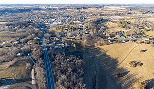
Preston covers about 2.45 square miles (6.38 square kilometers) of land. The South Branch of the Root River winds its way through the city.
Two main roads go through Preston. These are U.S. Highway 52 and Minnesota Highway 16.
Preston's Climate
Preston has a climate known as a "warm-summer humid continental climate." This means it has warm summers and cold winters. The hottest temperature ever recorded in Preston was 101°F (38°C). This happened on a few different dates, including July 18, 1964, and July 7, 2012. The coldest temperature ever recorded was a very chilly -45°F (-43°C). This happened on February 3, 1996, and February 1, 2019.
| Climate data for Preston, Minnesota, 1991–2020 normals, extremes 1952–present | |||||||||||||
|---|---|---|---|---|---|---|---|---|---|---|---|---|---|
| Month | Jan | Feb | Mar | Apr | May | Jun | Jul | Aug | Sep | Oct | Nov | Dec | Year |
| Record high °F (°C) | 57 (14) |
65 (18) |
82 (28) |
91 (33) |
94 (34) |
100 (38) |
101 (38) |
101 (38) |
98 (37) |
92 (33) |
76 (24) |
63 (17) |
101 (38) |
| Mean maximum °F (°C) | 44.2 (6.8) |
48.1 (8.9) |
65.7 (18.7) |
78.5 (25.8) |
86.2 (30.1) |
91.2 (32.9) |
92.0 (33.3) |
90.6 (32.6) |
87.4 (30.8) |
80.8 (27.1) |
64.4 (18.0) |
48.3 (9.1) |
94.0 (34.4) |
| Mean daily maximum °F (°C) | 23.6 (−4.7) |
28.2 (−2.1) |
40.9 (4.9) |
55.4 (13.0) |
67.6 (19.8) |
77.7 (25.4) |
81.1 (27.3) |
79.3 (26.3) |
72.5 (22.5) |
58.8 (14.9) |
42.7 (5.9) |
29.4 (−1.4) |
54.8 (12.6) |
| Daily mean °F (°C) | 13.8 (−10.1) |
18.1 (−7.7) |
30.7 (−0.7) |
43.7 (6.5) |
55.7 (13.2) |
65.9 (18.8) |
69.6 (20.9) |
67.5 (19.7) |
59.9 (15.5) |
46.7 (8.2) |
33.0 (0.6) |
20.5 (−6.4) |
43.8 (6.5) |
| Mean daily minimum °F (°C) | 4.1 (−15.5) |
8.0 (−13.3) |
20.6 (−6.3) |
32.1 (0.1) |
43.7 (6.5) |
54.0 (12.2) |
58.2 (14.6) |
55.7 (13.2) |
47.3 (8.5) |
34.6 (1.4) |
23.2 (−4.9) |
11.7 (−11.3) |
32.8 (0.4) |
| Mean minimum °F (°C) | −19.9 (−28.8) |
−15.3 (−26.3) |
−2.7 (−19.3) |
17.9 (−7.8) |
28.3 (−2.1) |
40.6 (4.8) |
47.4 (8.6) |
46.0 (7.8) |
32.2 (0.1) |
19.9 (−6.7) |
6.5 (−14.2) |
−10.4 (−23.6) |
−24.1 (−31.2) |
| Record low °F (°C) | −44 (−42) |
−45 (−43) |
−35 (−37) |
−8 (−22) |
18 (−8) |
31 (−1) |
35 (2) |
30 (−1) |
19 (−7) |
7 (−14) |
−19 (−28) |
−35 (−37) |
−45 (−43) |
| Average precipitation inches (mm) | 1.09 (28) |
1.18 (30) |
2.00 (51) |
3.84 (98) |
4.52 (115) |
5.95 (151) |
4.17 (106) |
4.29 (109) |
3.68 (93) |
2.73 (69) |
1.89 (48) |
1.44 (37) |
36.78 (935) |
| Average snowfall inches (cm) | 11.0 (28) |
8.2 (21) |
7.5 (19) |
2.5 (6.4) |
0.3 (0.76) |
0.0 (0.0) |
0.0 (0.0) |
0.0 (0.0) |
0.0 (0.0) |
0.3 (0.76) |
2.6 (6.6) |
9.8 (25) |
42.2 (107.52) |
| Average precipitation days (≥ 0.01 in) | 8.4 | 7.0 | 8.6 | 11.0 | 13.8 | 13.1 | 10.6 | 10.4 | 9.6 | 9.9 | 7.4 | 8.9 | 118.7 |
| Average snowy days (≥ 0.1 in) | 7.9 | 6.5 | 4.0 | 1.4 | 0.1 | 0.0 | 0.0 | 0.0 | 0.0 | 0.3 | 2.2 | 7.2 | 29.6 |
| Source 1: NOAA | |||||||||||||
| Source 2: National Weather Service | |||||||||||||
People of Preston
| Historical population | |||
|---|---|---|---|
| Census | Pop. | %± | |
| 1870 | 600 | — | |
| 1880 | 939 | 56.5% | |
| 1900 | 1,278 | — | |
| 1910 | 1,193 | −6.7% | |
| 1920 | 1,227 | 2.8% | |
| 1930 | 1,214 | −1.1% | |
| 1940 | 1,447 | 19.2% | |
| 1950 | 1,399 | −3.3% | |
| 1960 | 1,491 | 6.6% | |
| 1970 | 1,413 | −5.2% | |
| 1980 | 1,478 | 4.6% | |
| 1990 | 1,530 | 3.5% | |
| 2000 | 1,426 | −6.8% | |
| 2010 | 1,325 | −7.1% | |
| 2020 | 1,322 | −0.2% | |
| U.S. Decennial Census | |||
In 2010, there were 1,325 people living in Preston. These people made up 603 households. Most people (98.3%) were White. A small number were African American, Native American, or Asian. About 0.6% of the population was Hispanic or Latino.
Many households (47.3%) were married couples living together. About 24.9% of households had children under 18. The average age of people in Preston was 43.8 years old. About 21.4% of residents were under 18.
Outdoor Trails
Preston is connected to the Blufflands State Trail. This trail is great for walking, biking, and enjoying nature. It's called the Harmony-Preston Valley segment.
Education in Preston
Fillmore Central School District
The Fillmore Central School District is a public school district. It has two schools located right in Preston. These schools are for younger students. The Elementary School teaches kids from pre-kindergarten up to fourth grade. The Middle School is for students in fifth and sixth grade.
Older students, from seventh to twelfth grade, go to the High School. This high school is located in the nearby town of Harmony, Minnesota. In the 2005-2006 school year, the district had 641 students.
Preston Public Library
The Preston Public Library is a part of Southeastern Libraries Cooperating. This is a group of libraries in the Southeast Minnesota region. It's a great place to find books and learn new things.
See also
 In Spanish: Preston (Minnesota) para niños
 | DeHart Hubbard |
 | Wilma Rudolph |
 | Jesse Owens |
 | Jackie Joyner-Kersee |
 | Major Taylor |


