
Province of Barletta-Andria-Trani facts for kids
Quick facts for kids
Province of Barletta-Andria-Trani
|
||
|---|---|---|

Castel del Monte in Andria
|
||
|
||

Map with Barletta-Andria-Trani, in red, in Italy
|
||
| Country | ||
| Region | Apulia | |
| Capitala | Barletta, Andria and Trani | |
| Comuni | 10 | |
| Area | ||
| • Total | 1,542.95 km2 (595.74 sq mi) | |
| Population
(31 December 2015)
|
||
| • Total | 393,534 | |
| • Density | 255.0530/km2 (660.5842/sq mi) | |
| Time zone | UTC+1 (CET) | |
| • Summer (DST) | UTC+2 (CEST) | |
| Postal code |
70051-70001-70100
|
|
| Telephone prefix | 0883, 080 | |
| Vehicle registration | BT | |
| ISTAT | 110 | |
| Website | Official website: http://www.provincia.barletta-andria-trani.it/ | |

The Province of Barletta-Andria-Trani is a special area in the Apulia region of Southern Italy. It's like a county or district. This province is unique because it has three main cities that act as its capital: Barletta, Andria, and Trani. It is located right next to the Adriatic Sea.
Contents
History of the Province
This province is quite new! It was created from 10 smaller towns, called comuni. These towns used to be part of other provinces. Seven of them came from the Bari province. The other three came from the Foggia province. The new province was named after its three capital cities. These cities now share the job of running the province.
Geography of Barletta-Andria-Trani

The Province of Barletta-Andria-Trani is in the middle part of the Apulia region. It covers an area of about 1,543 square kilometers (596 square miles).
The province has several neighbors. To the northwest, it borders the Foggia province. The Adriatic Sea is to its north and northeast. To the east, it borders the Metropolitan City of Bari. Finally, to the south, it borders the province of Potenza in the Basilicata region.
The most important river in the province is the Ofanto river. It is also the main river in the entire Apulia region. The Ofanto river flows into the Adriatic Sea. It enters the sea between the towns of Margherita di Savoia and Barletta.
The highest point in the province is a mountain called Monte Caccia. It is 679 meters (2,228 feet) tall. This mountain is part of the Altopiano delle Murge. This is a special type of karstic plateau (a flat area of land made of limestone) in southern Italy.
Population and People
As of December 31, 2015, there were 393,534 people living in the province. This included 194,402 males and 199,132 females. This means that about 255 people live in each square kilometer of the province.
Administration and Towns
The province is made up of 10 towns, which are called comuni in Italy. These towns work together to manage the province.
| Comune (Town) | Population | Area (km²) | Altitude (m) |
|---|---|---|---|
| Andria | 100,440 | 402.89 | 151 |
| Barletta | 94,814 | 149.35 | 15 |
| Bisceglie | 55,422 | 69.25 | 16 |
| Canosa di Puglia | 30,294 | 150.93 | 105 |
| Margherita di Savoia | 11,974 | 35.70 | 1 |
| Minervino Murge | 9,032 | 257.41 | 429 |
| San Ferdinando di Puglia | 13,987 | 41.23 | 68 |
| Spinazzola | 6,621 | 184.01 | 435 |
| Trani | 56,217 | 103.41 | 7 |
| Trinitapoli | 14,217 | 148.77 | 5 |
Images for kids
-
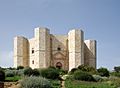
Castel del Monte is a famous castle in the province.
-
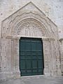
The beautiful Sant'Agostino church in Andria.
-
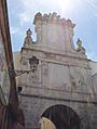
Porta Sant'Andrea, an old gate in Andria.
-

The impressive Barletta Castle.
-

The Colossus of Barletta, a huge ancient statue.
-

The grand Barletta Cathedral.
-
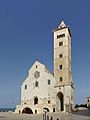
The stunning Trani Cathedral by the sea.
-
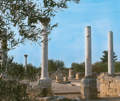
Ancient remains of the San Leucio Basilica in Canosa di Puglia.


See also
 In Spanish: Provincia de Barletta-Andria-Trani para niños
