Province of Verona facts for kids
Quick facts for kids
Province of Verona
|
|
|---|---|

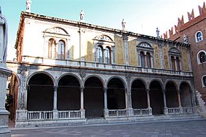
Loggia del Consiglio in Verona, the provincial seat.
|
|

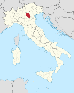
Map with the province of Verona, in red, in Italy
|
|
| Country | |
| Region | Veneto |
| Capital | Verona |
| Comuni | 98 |
| Area | |
| • Total | 3,096.39 km2 (1,195.52 sq mi) |
| Population
(1 January 2016)
|
|
| • Total | 922,383 |
| • Density | 297.8898/km2 (771.5310/sq mi) |
| Time zone | UTC+1 (CET) |
| • Summer (DST) | UTC+2 (CEST) |
| Postal code |
37121-37142 Verona, 37010-37069
|
| Telephone prefix | 045, 0442 |
| ISO 3166 code | IT-VR |
| Vehicle registration | VR |
| ISTAT | 023 |
| Website | Official website: http://www.provincia.verona.it/ |
The Province of Verona (which is Provincia di Verona in Italian) is a special area in the Veneto region of Italy. It's like a county or district. Its main city, or capital, is the famous city of Verona.
Contents
Geography of Verona Province
The Province of Verona covers about 3,096 square kilometers (1,195 sq mi). This makes it the second largest province in the Veneto region. It is located on the western side of the region.
Most of the land here is quite flat. However, there are a few mountains. The highest point in the province is a peak called Cima Valdritta. It stands tall at 2,218 meters (7,277 ft) high.
The main river flowing through the province is the Adige. This river even goes right through the capital city of Verona. To the west, you'll find Lake Garda (called Lago di Garda in Italian). It's the biggest lake in all of Italy!
The climate in the city of Verona is a Humid Subtropical climate. This means it has hot, humid summers and mild winters.
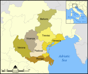
The Province of Verona shares its borders with several other areas. To the north, it meets the Province of Trento in the Trentino-Alto Adige/Südtirol region. To the east, it borders the Province of Vicenza and the Province of Padua. In the southeast, you'll find the Province of Rovigo.
To the south and west, it touches the Lombardy region, specifically the Province of Mantua. Finally, to the northwest, it borders the Province of Brescia, which is also in the Lombardy region.
 |
Brescia province (Lombardy region) |
Trento (Trentino-Alto Adige/Südtirol region) |
 |
|
| Mantua province (Lombardy region) |
Vicenza, Padua | |||
| Mantua province (Lombardy region) |
Rovigo |
Population in Verona Province
As of January 1, 2016, there were 922,383 people living in the Province of Verona. This means that for every square kilometer, there were about 297.9 people. This is called the population density.
Cities and Towns (Comuni)
In the Province of Verona, there are 98 different cities and towns. In Italy, these are called municipalities or comuni.
The largest comune by area is Verona itself, covering about 198.92 square kilometers (76.80 sq mi). The smallest comune is Concamarise, which is only about 7.91 square kilometers (3.05 sq mi).
The comune with the fewest people is Ferrara di Monte Baldo, with only 226 residents.
Biggest Cities and Towns (Main Comuni)
Here are the 10 comuni with the most people in the Province of Verona, based on numbers from 2016. The table also shows their size and how high they are above sea level.
| No. | Comune | Population (2016) |
Area (km²) |
Density | Altitude (m) |
|---|---|---|---|---|---|
| 1 | Verona | 258,765 | 198.92 | 1,300.8 | 59 |
| 2 | Villafranca di Verona | 33,194 | 57.34 | 578.9 | 54 |
| 3 | Legnago | 25,351 | 79.27 | 319.8 | 16 |
| 4 | San Giovanni Lupatoto | 25,066 | 19.01 | 1,318.6 | 42 |
| 5 | San Bonifacio | 21,284 | 33.79 | 629.9 | 31 |
| 6 | Bussolengo | 19,938 | 24.23 | 822.9 | 127 |
| 7 | Sona | 17,683 | 41.15 | 429.7 | 169 |
| 8 | Pescantina | 17,128 | 19.73 | 868.1 | 80 |
| 9 | Negrar | 17,119 | 40.42 | 423.5 | 190 |
| 10 | Cerea | 16,529 | 70.30 | 235.1 | 18 |
See also

- In Spanish: Provincia de Verona para niños
 | Isaac Myers |
 | D. Hamilton Jackson |
 | A. Philip Randolph |


