
Ptarmigan Traverse facts for kids
The Ptarmigan Traverse is a famous and challenging route for climbers in the North Cascades of Washington state. It's not a regular hiking trail. Instead, it's a remote path that crosses tough land and several glaciers. The route stretches from Cascade Pass all the way to Dome Peak.
The Story of the Ptarmigan Traverse
The very first time someone completed the Ptarmigan Traverse was in July 1938. It took a group of four climbers 13 days! These climbers were Bill Cox, Calder Bressler, Ray W. Clough, and Tom Myers. They were all part of the Ptarmigan Climbing Club.
The second group to complete the traverse was in 1953. One of the climbers, Tom Miller, took many amazing photos. These pictures showed the beautiful peaks, valleys, glaciers, and lakes along the way. Later, these photos were used in a book called The North Cascades. This book was very important in helping to create the North Cascades National Park.
The route gets its name from an alpine bird called the rock ptarmigan. It's a special bird that lives in cold, snowy mountains. The "p" at the beginning of "Ptarmigan" is silent, so you say it "TAR-mig-an."
In 1958, another group successfully completed the traverse. This trip was led by a photographer named Ira Spring. His stunning photos from the journey were even featured in an article in The Saturday Evening Post magazine. Today, the Ptarmigan Traverse is a popular goal for many mountaineers who love the Cascade Range.
Exploring the Ptarmigan Traverse
The Ptarmigan Traverse covers a long distance, going from north to south. It starts near Cascade Pass and ends at Dome Peak. Along the way, climbers cross many different types of terrain.
The journey begins near Cascade Pass (about 5,351 feet (1,631 m) high). This is where the last easy trail ends. From there, the route becomes much more difficult. Climbers pass by impressive mountains like Buckner Mountain (9,091 feet (2,771 m)) and Boston Peak (8,845 feet (2,696 m)). They also go over high points like Cache Col (6,903 feet (2,104 m)), which marks the boundary between North Cascades National Park and Glacier Peak Wilderness.
As climbers continue, they encounter more challenging areas. This includes crossing the Middle Cascade Glacier (at about 5,748 feet (1,752 m)). They also navigate around tall peaks such as Mount Formidable (8,340 feet (2,540 m)) and Spider Mountain (8,291 feet (2,527 m)).
Further south, the route involves crossing the LeConte Glacier (around 7,434 feet (2,266 m)) and going past Sentinel Peak (8,205 feet (2,501 m)). A significant part of the journey involves the South Cascade Glacier (about 6,138 feet (1,871 m)). This is one of the largest glaciers on the route. Climbers also pass by the beautiful White Rock Lakes (at 6,197 feet (1,889 m)).
The traverse finishes near Dome Peak (8,852 feet (2,698 m)). This final section includes crossing the Dana Glacier (around 6,735 feet (2,053 m)) and going past Spire Point (8,146 feet (2,483 m)). The entire route is a true adventure for experienced climbers.
Images for kids
-
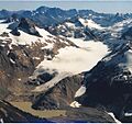
A portion of the southern Ptarmigan Traverse, looking east. The route climbs the LeConte Glacier, goes around Sentinel Peak, descends to the South Cascade Glacier, and crosses over to the White Rock Lakes.

