
Sentinel Peak (Washington) facts for kids
Quick facts for kids Sentinel Peak |
|
|---|---|
 |
|
| Highest point | |
| Elevation | 8,266 ft (2,519 m) NAVD 88 |
| Geography | |

Sentinel Peak
Location in Washington (state)

Sentinel Peak
Location in the United States
|
|
| Parent range | Cascade Range, North Cascades |
| Topo map | USGS Dome Peak |
Sentinel Peak is a tall mountain in Washington, standing at about 8,266 feet (2,519 meters) high. It's found in the Glacier Peak Wilderness, a special protected area in the North Cascades mountains. The top of Sentinel Peak is part of a famous hiking and climbing route called the Ptarmigan Traverse.
This mountain sits right on the highest part, or "crest," of the Cascade Range. It's also on the border between Snohomish County and Chelan County. This means it's split between two large protected areas: the Mount Baker-Snoqualmie National Forest and the Wenatchee National Forest. You can find the South Cascade Glacier on its western side and the LeConte Glacier on its northeast side. The closest taller mountain is Spire Point, which is about 3 miles (4.8 kilometers) away to the south-southwest.
What is the Climate Like at Sentinel Peak?
Sentinel Peak is located in a place with a "marine west coast" climate. This means it gets a lot of moisture from the Pacific Ocean. Most of the weather systems, like storms, start over the Pacific Ocean and move towards the Cascade Range.
When these weather systems hit the tall peaks of the Cascades, they are forced to rise. As the air goes higher, it cools down and drops its moisture. This process is called Orographic lift. Because of this, the western side of the North Cascades gets a lot of rain and snow, especially in winter.
The climate here is mild. Temperatures rarely go below 0°F (-18°C) or above 80°F (27°C). In winter, it's often cloudy. But in summer, high-pressure systems over the Pacific Ocean bring clear skies and sunshine.
How Did Sentinel Peak Form?
The North Cascades mountains, where Sentinel Peak is located, have very rugged and dramatic landscapes. You can see sharp peaks, long ridges, and deep valleys carved by glaciers. These amazing features were created by geological events that happened millions of years ago.
The Cascade Range began forming a very long time ago, during the late Eocene Epoch. This was when the North American Plate slowly moved over the Pacific Plate. This movement caused a lot of volcanic activity. For example, Glacier Peak, a large volcano about 17 miles (28 kilometers) south-southwest of Sentinel Peak, started to form during the mid-Pleistocene period.
Also, small pieces of the Earth's crust, called terranes, came together to form the North Cascades about 50 million years ago.
During the Pleistocene period, which was over two million years ago, large sheets of ice called glaciers moved across the land many times. As they advanced and retreated, they carved out the landscape, leaving behind rock and debris. The U-shaped valleys you see in the area were formed by these glaciers. The combination of the land pushing upwards (called uplift) and cracks in the Earth's crust (called faulting), along with the action of glaciers, created the tall peaks and deep valleys of the North Cascades.
Images for kids
-
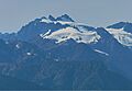
Sentinel Peak seen from the northeast, near Maple Pass.

