Spire Point facts for kids
Quick facts for kids Spire Point |
|
|---|---|

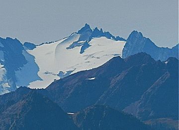
Spire Point seen from Maple Pass
|
|
| Highest point | |
| Elevation | 8,264 ft (2,519 m) |
| Prominence | 784 ft (239 m) |
| Geography | |
| Location | Chelan and Skagit County, Washington, U.S. |
| Parent range | Cascade Range |
| Topo map | USGS Dome Peak |
| Climbing | |
| Easiest route | class 5 |
Spire Point is a tall mountain in Washington, USA. It stands at about 8,264 feet (2,519 m) high. This mountain is part of the Mount Baker-Snoqualmie and Wenatchee National Forests. You can find two glaciers near it: Spire Glacier on its northwest side and Dana Glacier to the east. Climbing Spire Point is quite challenging and needs special skills.
Contents
Mountain Weather: Spire Point's Climate
Spire Point is in a special weather area called the "marine west coast climate zone." This means it gets a lot of moisture from the ocean. Most of the weather systems start over the Pacific Ocean. They then travel northeast towards the Cascade Mountains.
How Mountains Make Rain and Snow
When these weather systems reach the North Cascades, the tall mountains force the air upwards. As the air rises, it cools down. This cooling causes the moisture in the air to turn into rain or snowfall. This process is called "orographic lift." Because of this, the western side of the North Cascades gets a lot of rain and snow, especially in winter.
Seasonal Weather Patterns
During winter, the weather is usually cloudy. However, in summer, high-pressure systems over the Pacific Ocean become stronger. This often leads to clear skies and sunny weather around Spire Point.
The Story of Spire Point's Rocks
The North Cascades are known for their rough and jagged look. You can see sharp peaks, tall spires, long ridges, and deep valleys carved by glaciers. These features tell a long story about how the mountains were formed.
How the Cascades Were Formed
The creation of the Cascade Mountains began millions of years ago. This was during a time called the late Eocene Epoch. Over two million years ago, during the Pleistocene period, huge sheets of ice called glaciers moved across the land many times. These glaciers scraped and shaped the landscape.
Glaciers and Valleys
The valleys you see today often have a "U" shape. This special shape was created by the glaciers as they moved through the land. The combination of the land being pushed up (called uplift) and cracks forming in the Earth's crust (called faulting) worked with the glaciers. Together, these powerful forces created the tall peaks and deep valleys of the North Cascades area.
 | Isaac Myers |
 | D. Hamilton Jackson |
 | A. Philip Randolph |


