Buckner Mountain facts for kids
Quick facts for kids Buckner Mountain |
|
|---|---|
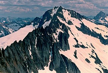
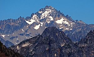
Buckner Mountain from Sahale Mountain
|
|
| Highest point | |
| Elevation | 9,114 ft (2,778 m) |
| Prominence | 3,034 ft (925 m) |
| Parent peak | Goode Mountain |
| Geography | |
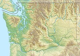
| Location | Chelan and Skagit Counties, Washington, United States |
| Parent range | North Cascades |
| Topo map | Goode Mountain |
| Climbing | |
| First ascent | Lewis Ryan, 1901-08-01 |
Buckner Mountain, also known as Mount Buckner, is a very tall mountain peak. It is found in the North Cascades mountain range in Washington state, USA. This impressive mountain is also part of the Stephen Mather Wilderness area, which is inside North Cascades National Park.
Standing at 9,114 feet (2,778 meters) high, Buckner Mountain is the tallest peak in Skagit County. It is one of only about ten peaks in Washington that are over 9,000 feet tall and are not volcanoes. In fact, it's the 14th highest mountain in the entire state and the third highest in North Cascades National Park.
Contents
What Does Buckner Mountain Look Like?
Buckner Mountain actually has two main tops, called summits, that are almost the same height. These two summits are separated by a ridge, which is like a high, narrow path of rock. The southwest summit is thought to be slightly taller, at 9,114 feet (2,778 meters). The northeast summit is very close in height, at 9,112 feet (2,777 meters).
Most mountain climbers who visit Buckner Mountain usually go to the southwest summit. This is because it's the first one they reach when using the most common climbing path, called the Horseshoe Basin route.
Buckner Mountain is quite prominent, meaning it rises very high above the land around it. Its prominence is 3,034 feet (925 meters), making it the 51st most prominent peak in Washington state. The closest mountain that is taller than Buckner is Goode Mountain, which is about 4.13 miles (6.65 km) to the east.
Where is Buckner Mountain Located?
Buckner Mountain sits right on the border between Chelan and Skagit counties. To the west, it connects to other peaks like Horseshoe Peak, Boston Peak, and Sahale Mountain through a rocky ridge called Ripsaw Ridge. This ridge actually forms part of the county line for several miles.
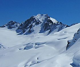
A few miles south of Sahale Mountain, you'll find Cascade Pass, a well-known mountain pass. The Boston Glacier, which is the biggest glacier in the North Cascades, covers the entire area north of Ripsaw Ridge. South of the ridge, the land slopes down into a large area called Horseshoe Basin. This basin is where some of the small streams that form the Stehekin River begin.
Long, high ridges stretch from Buckner Mountain to the east towards Park Creek Pass. Other ridges go south to Booker Mountain and Park Creek Ridge. There are also other glaciers nearby, such as Thunder Glacier to the north and Buckner Glacier to the south.
Buckner Mountain also marks an important natural boundary. To the west, water flows into the Skagit River system. To the east, water flows into the Columbia River system, through its smaller rivers and lakes like the Chelan River and Lake Chelan.
How Did Buckner Mountain Get Its Name?
Buckner Mountain is named after Henry Freeland Buckner. In the early 1900s, he managed a mining company. This company had mining claims in the Horseshoe Basin, which is southwest of the mountain.
Weather and Climate Around Buckner Mountain
Buckner Mountain is in a region with a "marine west coast" climate. This means the weather is heavily influenced by the nearby Pacific Ocean. Most weather systems, like storms, come from the Pacific Ocean and move northeast towards the Cascade Range.
As these weather systems hit the tall peaks of the North Cascades, they are forced to rise. This causes them to drop their moisture as rain or snow onto the mountains. Because of this, the western side of the North Cascades gets a lot of precipitation, especially heavy snowfall in winter.
During winter, the weather is often cloudy. However, in summer, high-pressure systems over the Pacific Ocean usually bring clear skies. The ocean's influence also means that the snow tends to be wet and heavy, which can sometimes lead to avalanche danger.
The Geology of the North Cascades
The North Cascades mountains are known for their very rugged and dramatic landscape. You can see jagged peaks, sharp ridges, deep valleys carved by glaciers, and tall granite spires. These amazing features were created by geological events that happened millions of years ago. These events caused huge changes in the land's height and led to different climates and types of plants in the area.
The Cascade Mountains began to form millions of years ago, during a time called the late Eocene Epoch. This happened because the North American Plate (a huge piece of the Earth's crust) was slowly moving over the Pacific Plate. This movement caused many volcanic eruptions. Also, smaller pieces of the Earth's crust, called terranes, came together to form the North Cascades about 50 million years ago.
Over two million years ago, during the Pleistocene period, huge sheets of ice called glaciers moved across the land. These glaciers repeatedly advanced and then melted back, carving out the landscape and leaving behind rock debris. The "U"-shaped valleys you see in the mountains today are a direct result of these ancient glaciers.
The combination of the land being pushed upwards (uplift) and breaking along cracks (faulting), along with the action of glaciers, has created the tall peaks and deep valleys that make the North Cascades so unique.
Fun Things to Do at Buckner Mountain
Buckner Mountain is one of the easier tall peaks in Washington to reach. It's located just east of Cascade Pass, and there's a well-maintained trail nearby.
For experienced climbers, the Boston Glacier, which is on the north side of the mountain, is a very popular spot for ice climbing in the North Cascades.
 | James Van Der Zee |
 | Alma Thomas |
 | Ellis Wilson |
 | Margaret Taylor-Burroughs |


