
Spider Mountain facts for kids
Quick facts for kids Spider Mountain |
|
|---|---|

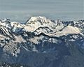
Spider Mountain from Maple Pass
|
|
| Highest point | |
| Elevation | 8,286 ft (2,526 m) |
| Prominence | 926 ft (282 m) |
| Isolation | 1.33 mi (2.14 km) |
| Parent peak | Mount Formidable (8,325 ft) |
| Geography | |

Spider Mountain
Location in Washington (state)

Spider Mountain
Location in the United States
|
|
| Parent range | North Cascades Cascade Range |
| Topo map | USGS Cascade Pass |
| Type of rock | Schist |
| Climbing | |
| First ascent | 1938, Calder Bressler, Ralph Clough, Bill Cox, Tom Myers |
| Easiest route | Scrambling Glacier travel |
Spider Mountain is a tall mountain peak in the state of Washington, USA. It stands about 8,286 feet (2,526 meters) high. You can find it in the Glacier Peak Wilderness area, which is part of the North Cascades mountain range.
Water from the Spider Glacier flows down the mountain. This water, along with other runoff, goes into Flat Creek. Flat Creek then joins the Stehekin River. A nearby mountain called Mount Formidable is about 1.5 miles (2.4 km) to the west. The Middle Cascade Glacier is located between these two mountains. A famous hiking route, the Ptarmigan Traverse, also goes through this area.
Contents
Understanding the Climate Around Spider Mountain
Spider Mountain is in a place with a "marine west coast" climate. This means it gets a lot of moisture from the Pacific Ocean. Most of the weather systems start over the Pacific. They then travel northeast towards the Cascade Mountains.
How Weather Affects the Cascades
When these weather systems reach the North Cascades, the tall mountains force the air upwards. As the air rises, it cools down and drops its moisture. This process is called Orographic lift. It causes a lot of rain or snowfall on the western side of the North Cascades.
During winter, it's usually cloudy and snowy. But in summer, high-pressure systems over the Pacific Ocean often bring clear skies. The best time for climbing Spider Mountain is usually from July to September. This is when the weather is most favorable.
Exploring the Geology of the North Cascades
The North Cascades are known for their very rugged landscape. You'll see sharp, jagged peaks, long ridges, deep valleys carved by glaciers, and tall spires made of granite. These amazing shapes were created by geological events that happened millions of years ago. These events also led to big changes in elevation and different climates across the Cascade Range.

How the Mountains Were Formed
The Cascade Mountains began to form millions of years ago, during a time called the late Eocene Epoch. This happened because the North American Plate was slowly moving over the Pacific Plate. This movement caused many volcanic eruptions over a long period.
Also, small pieces of the Earth's crust, called terranes, came together. These pieces of both ocean and continental crust helped build the North Cascades about 50 million years ago.
The Impact of Glaciers
During the Pleistocene period, which was over two million years ago, huge sheets of ice called glaciers moved across the land. They advanced and then melted back many times. As they moved, they scraped and shaped the landscape. They left behind piles of rock and debris.
The "U"-shaped valleys you see in the mountains are a result of these glaciers. The combination of the land being pushed up (called uplift) and cracks in the Earth's crust (called faulting), along with the action of glaciers, created the tall peaks and deep valleys of the North Cascades.
Images for kids
-
Southwest aspect seen from Green Mountain

