Pugwash River facts for kids
Quick facts for kids Pugwash River |
|
|---|---|

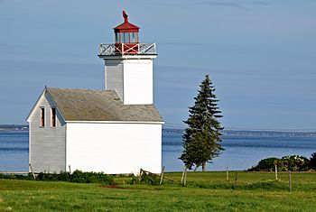
1871 Pugwash Lighthouse at the entrance to Pugwash Harbor and the Pugwash River
|
|
| Country | Canada |
| Province | Nova Scotia |
| County | Cumberland |
| Physical characteristics | |
| Main source | 45°41′37″N 63°47′04″W / 45.693749°N 63.784435°W |
| River mouth | Pugwash, Nova Scotia 45°51′04″N 63°40′02″W / 45.851160°N 63.667230°W |
The Pugwash River is a river in Nova Scotia, Canada. It flows north into the Northumberland Strait. The river ends in the village of Pugwash.
Contents
Pugwash Harbour: A Safe Place for Ships
Pugwash Bay has a very good harbour. Ships as large as 500 tons could safely dock close to the shore. The channel is about a quarter-mile wide. Above the channel, it opens into a beautiful basin. The Pugwash River flows into this basin.
The harbour is small but very safe. It has enough deep water for ships that can cross the sandbar. This sandbar is about half a mile inside the bay's entrance. The water over the bar is about 14 feet deep at low tide. Getting through the winding channel needs help from local pilots.
The Pugwash Lighthouse was built in 1871. It stands on Fishing Point at the entrance to Pugwash Harbour. The last person who looked after the lighthouse left in 1959. By 2017, the building was not in good shape. Today, large ships called bulk carriers visit the Port of Pugwash. They carry salt from the local salt mine.
Pugwash Village: History and Salt
The village of Pugwash is known as Pagwe'ak in the Mi'kmaq language. Settlers from New England first came here in the late 1700s. They received land from the Nova Scotia government. Later, United Empire Loyalists from the United States also settled here.
The village grew by building ships and selling lumber to Europe. The town of Pugwash has wharves and a small wooden church. Inside the harbour, there is a calm basin. It is nearly 7 fathoms (about 42 feet) deep. Ships could anchor there safely to load lumber from the river.
The Canadian Salt Mine Company opened an underground mine in 1959. Many of its tunnels run under the river near the village. The mine was still working in 2010. People wondered how long it would keep going.
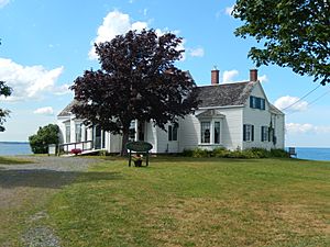
Pugwash is famous for the first Pugwash Conferences on Science and World Affairs. In July 1957, Bertrand Russell invited nuclear scientists to discuss world peace. The meeting happened at the Thinker's Lodge. This building was built in the 1830s. It was owned by Cyrus S. Eaton, a millionaire born in Pugwash.
Pugwash Estuary: A Special Place for Nature
Right inside the harbour, the Pugwash River widens into a small lake. This lake is about 1.5 miles long and one mile wide. A narrow channel called Lime Creek leads to limestone quarries. The river can be used by small ships for about 2 miles above the lake. Boats can travel up to 7 miles from the entrance.
The Pugwash River Estuary is the largest estuary along Nova Scotia's Northumberland Strait coast. An estuary is where a river meets the sea. The shoreline here is mostly untouched. The water in the estuary is unusually warm.
Plants and Animals of the Estuary
The estuary has sandy beaches and salt marshes. Forests grow along the edges of these areas. These forests have trees like tsuga (hemlock), betula alleghaniensis (yellow birch), and acer saccharum (sugar maple).
Many birds use the estuary. Migrating waterfowl like Canada goose, American black duck, great blue heron, and green-winged teal visit. Shorebirds such as semipalmated sandpiper and willet also rest here in the spring and fall. The piping plover (an endangered bird) and Barrow's goldeneye (a bird at risk) are also found here. The Nature Conservancy of Canada helps protect about 417 hectares of this important estuary.
Pugwash River: From Mountains to the Sea
The Pugwash River starts from small streams in the Cobequid Mountains. These mountains are covered in thick forests. They are about 1,000 feet high. The river begins just south of Highway 104, near Oxford.
It flows northeast towards Pugwash. This journey is about 20 kilometers (12 miles) in a straight line. The river passes through places like Birchwood, Hansford, and East Hansford. Here, it gets water from McPherson Lake. The river gets wider near Conns Mill. It then turns north, then east, then north again. Finally, it enters Pugwash Basin, south of Pugwash village.
Challenges for Fish
In the past, there were many alewife herring (gaspereaux) in the river. However, about 5 miles up the river, a dam was built for McPherson's saw mill. This dam was 8 feet high. It had no way for fish to get past it. This meant fish could not reach the good water further upstream.
Another dam at McArthur's saw mill also blocked fish. People saw many fish in the tideway, but they couldn't swim upriver to lay their eggs. The water below the mill was often full of sawdust.
In 1891, a fisheries overseer reported problems with fishing. The smelt fish were too small to sell. He also noted that sawdust and old trees were harming the fish. Oyster beds in the Pugwash River were covered with sawdust. This made it hard for people to collect oysters. Fish ladders were needed at several mills to help fish move up the river.
 | William Lucy |
 | Charles Hayes |
 | Cleveland Robinson |


