Queets, Washington facts for kids
Quick facts for kids
Queets, Washington
|
|
|---|---|

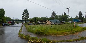
An intersection in Queets
|
|
| Country | United States |
| State | Washington |
| Counties | Grays Harbor, Jefferson |
| Area | |
| • Total | 1.4 sq mi (3.7 km2) |
| • Land | 1.4 sq mi (3.6 km2) |
| • Water | 0 sq mi (0.0 km2) |
| Elevation | 30 ft (9 m) |
| Population
(2020)
|
|
| • Total | 136 |
| • Density | 95.2/sq mi (36.8/km2) |
| Time zone | UTC-8 (Pacific (PST)) |
| • Summer (DST) | UTC-7 (PDT) |
| ZIP Code |
98331
|
| FIPS code | 53-56905 |
| GNIS feature ID | 1524759 |
Queets is a small community in Washington state, United States. It is located in both Grays Harbor and Jefferson counties. In 2020, 136 people lived there. Most of the people living in Queets are Native Americans from the Quinault Indian Nation.
Contents
History of Queets
Queets had its own post office for many years. It first opened on July 13, 1880. The post office helped people send and receive mail.
However, the post office eventually closed. It stopped operating on July 31, 1934. After it closed, mail for Queets was sent to Clearwater. Clearwater is a community about 8 miles (13 km) away.
Geography and Location
Queets is located near the Pacific Ocean coast. It sits along the Queets River. The community is also at the northern edge of the Quinault Indian Reservation.
What You Can Find in Queets
Queets is a small but active place. It has several homes where people live. There is also a store and a gas station. The community supports its residents with important services. These include fisheries, a daycare center, and a Head Start program. The Quinault Nation also has a remote office here.
Nearby Attractions and Travel
There are many interesting places to visit near Queets. You can explore hiking trails along the Pacific beach. The famous Olympic National Park is also close by. Another beautiful area is the Olympic National Forest.
U.S. Route 101 is a main road that goes through Queets. This highway crosses the Queets River at the northern part of the community. If you drive north on US 101, you will reach Kalaloch Beach in about 5 miles (8 km). The town of Forks, which has the closest airport, is about 39 miles (63 km) north.
If you drive south on US 101, you will go east to Amanda Park. This town is about 25 miles (40 km) away. Continuing southeast, you will reach Aberdeen in about 68 miles (109 km).
Land and Water Area
The total area of the Queets community is about 3.7 square kilometers (1.4 square miles). Most of this area is land. About 3.6 square kilometers (1.4 square miles) is land. The rest is water. The water area is about 0.1 square kilometers (0.04 square miles). This means about 3.45% of Queets is water.
Population and People
The population of Queets was counted in the 2020 census. At that time, 136 people lived there. This was a decrease from the 2010 census, when 174 people lived in Queets.
In the 2010 census, more than 95% of the people living in Queets identified as American Indian. This shows that the community is mainly made up of people from the Quinault Indian Nation.
See also
 In Spanish: Queets (Washington) para niños
 | Valerie Thomas |
 | Frederick McKinley Jones |
 | George Edward Alcorn Jr. |
 | Thomas Mensah |


