
Quitman County, Georgia facts for kids
Quick facts for kids
Quitman County
|
||
|---|---|---|

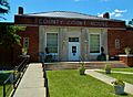
Quitman County Courthouse in Georgetown
|
||
|
||

Location within the U.S. state of Georgia
|
||
 Georgia's location within the U.S. |
||
| Country | ||
| State | ||
| Founded | December 10, 1858 | |
| Named for | John A. Quitman | |
| Seat | Georgetown | |
| Largest city | Georgetown | |
| Area | ||
| • Total | 161 sq mi (420 km2) | |
| • Land | 151 sq mi (390 km2) | |
| • Water | 9.3 sq mi (24 km2) 5.8%% | |
| Population
(2020)
|
||
| • Total | 2,235 | |
| • Density | 15/sq mi (6/km2) | |
| Time zone | UTC−5 (Eastern) | |
| • Summer (DST) | UTC−4 (EDT) | |
| Congressional district | 2nd | |

Quitman County is a county in the southwestern part of Georgia, a state in the United States. In 2020, about 2,235 people lived there, making it one of Georgia's smallest counties by population. The main town and county seat is Georgetown.
The county was created on December 10, 1858. It was named after General John A. Quitman, who was a leader in the Mexican–American War and once served as the Governor of Mississippi. In 2006, people in Quitman County voted to combine the city government of Georgetown with the county government. This created a consolidated city-county, meaning they now work together as one.
Contents
Geography of Quitman County
Quitman County covers a total area of about 161 square miles. Most of this area, about 151 square miles, is land. The remaining 9.3 square miles, which is about 5.8% of the total area, is water.
The entire county is located within the Middle Chattahoochee River–Walter F. George Lake area. This area is part of a larger river system called the ACF River Basin, which includes the Apalachicola, Chattahoochee, and Flint Rivers.
Main Roads in Quitman County
Several important roads pass through Quitman County, helping people travel around the area.
 U.S. Route 82
 State Route 27
 State Route 39
 State Route 50
Neighboring Counties
Quitman County shares its borders with several other counties.
- Stewart County (to the north)
- Randolph County (to the east)
- Clay County (to the south)
- Barbour County, Alabama (to the west; this border is also a time zone change)
Protected Natural Areas
Part of the Eufaula National Wildlife Refuge is located within Quitman County. This refuge is a special area set aside to protect wildlife and their natural homes.
Communities in Quitman County
Quitman County has one main city and an unincorporated community.
City
- Georgetown is the largest town and the county seat. This means it's where the county government offices are located.
Unincorporated Community
- Morris is a smaller community that does not have its own city government.
Population of Quitman County
| Historical population | |||
|---|---|---|---|
| Census | Pop. | %± | |
| 1860 | 3,499 | — | |
| 1870 | 4,150 | 18.6% | |
| 1880 | 4,392 | 5.8% | |
| 1890 | 4,471 | 1.8% | |
| 1900 | 4,701 | 5.1% | |
| 1910 | 4,594 | −2.3% | |
| 1920 | 3,417 | −25.6% | |
| 1930 | 3,820 | 11.8% | |
| 1940 | 3,435 | −10.1% | |
| 1950 | 3,015 | −12.2% | |
| 1960 | 2,432 | −19.3% | |
| 1970 | 2,180 | −10.4% | |
| 1980 | 2,357 | 8.1% | |
| 1990 | 2,209 | −6.3% | |
| 2000 | 2,598 | 17.6% | |
| 2010 | 2,513 | −3.3% | |
| 2020 | 2,235 | −11.1% | |
| 2023 (est.) | 2,280 | −9.3% | |
| U.S. Decennial Census 1790-1880 1890-1910 1920-1930 1930-1940 1940-1950 1960-1980 1980-2000 2010 |
|||
The population of Quitman County has changed over the years. In 2020, the census counted 2,235 people living in the county. These people lived in 842 households, with 577 of those being families.
Education in Quitman County
The Quitman County School District is in charge of the public schools in the area. This includes Quitman County High School.
For many years, students from Quitman County attended Stewart-Quitman High School. This school is now known as Stewart County High School. Quitman County High School opened its doors in 2009, giving local students a school closer to home.
Images for kids
-
The Quitman County Courthouse in Georgetown.
See also
 In Spanish: Condado de Quitman (Georgia) para niños
