Bucaná River facts for kids
Quick facts for kids Bucaná River |
|
|---|---|

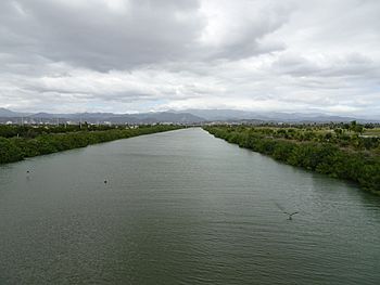
Río Bucaná, looking north, from Puente de la Avenida Caribe, Barrio Playa, Ponce
|
|
| Commonwealth | Puerto Rico |
| Municipality | Ponce |
| Physical characteristics | |
| Main source | Barrio Machuelo Arriba 115 feet (35 m) 17°58′07″N 66°36′00″W / 17.9685786°N 66.5998946°W |
| River mouth | Barrio Playa, Caribbean Sea 0 feet (0 m) (Caribbean Sea) |
| Length | 5.69 miles (9.16 km) |
| Basin features | |
| Progression | Machuelo Abajo Sabanetas Bucaná Playa (Ponce) |
| River system | Río Bucaná |
| Basin size | 28.45 sq mi (73.7 km2) |
| Tributaries |
|
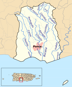
The Bucaná River (known as Spanish: Río Bucaná in Spanish) is an important river located in the city of Ponce, Puerto Rico. It starts in an area called Machuelo Arriba, about 115 feet (35 meters) above sea level. This river is special because it's formed by the joining of two other rivers, the Río Cerrillos and the Río Bayagán.
As it flows south, the Bucaná River also gets water from the Río Portugues. While it used to be much longer, running for about 18 miles (29.5 kilometers), parts of it have been changed by engineers. Now, it flows for about 5.89 miles (9.48 kilometers) before it reaches and empties into the Caribbean Sea. The Bucaná River is one of 14 rivers found in the municipality of Ponce.
What are Tributaries?
A tributary is a smaller stream or river that flows into a larger river. Think of it like smaller branches joining a main tree trunk. The Bucaná River is formed in the Machuelo Arriba area when the Bayagán River and the Cerrillos River come together. These two rivers are its main sources. It also receives water from the Río Portugues as it continues its journey.
Where Does the River Flow?
The Bucaná River begins in the Central Mountain Range of Puerto Rico, specifically near Monte Jayuya. From there, it takes a winding path, flowing generally south. Along its way, it collects water from other smaller streams like the Rio Jauca, Rio Bayagan, and Quebrada Guayo.
A big part of the Bucaná River, especially as it enters the city of Ponce, has been "channelized." This means its path has been straightened and its banks reinforced with concrete. This project helps control flooding, especially during heavy rains. The channelization work started in 1974 and was finished in 1997. It was a huge project that cost a lot of money!
The river eventually flows into the Caribbean Sea near a popular spot called La Guancha. In the past, a section of the river used to run next to Route 14, but its path has since been changed to improve the area.
How the River is Used
The Bucaná River plays an important role in the southern part of Puerto Rico. Its waters are mostly used for irrigation. Irrigation is when water is supplied to help grow crops, especially in dry areas. The river helps farmers on the flat lands east of Ponce grow their plants and vegetables.
See also
 In Spanish: Río Bucaná para niños
- List of rivers of Puerto Rico
- List of rivers of Ponce


