Portugués River facts for kids
Quick facts for kids Río Portugués |
|
|---|---|

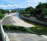
Portugues River in Ponce, Puerto Rico, looking north from Puente de Los Leones at Miguel Pou Boulevard (PR-1)
|
|
| Other name(s) | Río Baramaya, Río Ponce, Río Tibes |
| Commonwealth | Puerto Rico |
| Municipality | Ponce |
| Physical characteristics | |
| Main source | Barrio Portugués, Adjuntas, Puerto Rico 2,853 feet (870 m) 17°59′31.488″N 66°35′51.2874″W / 17.99208000°N 66.597579833°W |
| River mouth | Bucaná River 3 feet (0.91 m) |
| Length | 18.43 miles (29.66 km) |
| Basin features | |
| Progression | Guaraguao San Patricio Tibes Portugués Machuelo Arriba Sexto Quinto Tercero Cuarto San Antón Playa |
| River system | Río Bucaná |
| Basin size | 20.33 sq mi (52.7 km2) |
| Tributaries |
|
The Río Portugués is an important river in the city of Ponce, Puerto Rico. It was once known as Río de Ponce in the 1800s. Many bridges cross the Río Portugués in Ponce, helping people get around. In some areas, like Tibes, people call it Río Tibes.
This river is about 30 kilometers (19 mi) long. It starts high up in the Cordillera Central mountains and flows south. It eventually reaches the Caribbean Sea. The Río Portugués is famous in Ponce because it winds through the city. It also has a lot of history. The city of Ponce actually began on the banks of this river. Long ago, it was called Río Baramaya.
Contents
Where the River Starts
The Río Portugués begins in a place called Cerro Guilarte. This mountain is in the western part of barrio Portugués, near Adjuntas. This area is just north of Ponce. The river then flows into the Caribbean Sea. It travels about 27.6 kilometers (17.1 mi) to get there. The river moves a lot of water, about 16,000 cubic feet per second!
The name "Portugués" comes from one of the first people who settled here. His name was Pedro Rodríguez de Guzman. People called him el Portugués because his family came from Portugal.
Rivers That Join It
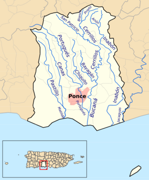
The Río Chiquito is a smaller river that flows into the Río Portugués. Rivers that flow into a larger river are called tributaries. People living in different areas along the Río Portugués sometimes call it by other names. For example, in the areas of Cedro, Nuez, Moscada, and Tibes, locals might call it Río Cedro, Río Nuez, Río Moscada, or Río Tibes.
How the River Flows Through Ponce
The Río Portugués starts high up, about 2,853 feet (870 meters) above sea level. It flows south, mostly next to PR-10. It passes through different areas like Guaraguao, San Patricio, and Tibes.
As it gets closer to Ponce, it goes past Machuelo Arriba. Then it enters Machuelo Abajo. It crosses major roads like Avenida Betances/Avenida Tito Castro (PR-14). In the city, the river separates different neighborhoods. For example, it divides Sexto from Machuelo Abajo. It also separates Quinto from Machuelo Abajo.
Further downstream, it goes by Puente de los Leones and Tricentennial Park. Here, it divides Tercero and San Antón. It also flows near La Ceiba Park. Finally, it continues south towards Avenida Las Américas (PR-163).
The table below shows some of the roads and bridges the river crosses as it flows from north to south:
| No. | Barrio | Road | Bridge name (if any) |
|---|---|---|---|
| 1 | Guaraguao | PR-10 | Unnamed |
| 2 | San Patricio | PR-10 | Unnamed |
| 3 | Tibes | PR-503 | Unnamed |
| 4 | Tibes | PR-503 | Unnamed |
| 5 | Tibes | PR-10 | Unnamed |
| 6 | Tibes | PR-10 | Unnamed |
| 7 | Portugués Rural | PR-10 | Unnamed |
| 8 | Portugués Rural | PR-504 | Unnamed |
| 9 | Machuelo Abajo | PR-14 | Unnamed |
| 10 | Cantera | PR-14R | La Milagrosa |
| 11 | Tercero | PR-1 | Los Leones |
| 12 | San Antón | PR-133 | Unnamed |
| 13 | San Antón | Calle Campos | Unnamed |
| 14 | San Antón | PR-163 | Unnamed |
| 15 | San Antón | PR-163 | Unnamed |
| 16 | San Antón | PR-12 | Unnamed |
| 17 | San Antón | PR-2 | Unnamed |
| 18 | San Antón | PR-52 | Unnamed |
| 19 | Playa | Av. Caribe | Unnamed |
| 20 | Playa | PR-2 | Caracoles |
| 21 | Playa | PR-123 | Río Portugués |
| 22 | Playa | PR-585 | Unnamed |
How the River's Path Changed
In the 1970s, the U.S. Army Corps of Engineers changed the path of the Río Portugués. This was done to help control floods. Instead of flowing directly into the Caribbean Sea at Playa de Ponce, it now flows into the Bucaná River. The Bucaná River then empties into the sea. This big project started in 1974 and finished in 1997. It cost a lot of money to complete.
The Old Path
Before the changes, the Río Portugués flowed south-southwest. It crossed Avenida Las Américas and went behind the police headquarters. It then crossed PR-2 near a place called "Caracoles." The old path also went near where Plaza del Caribe is now. It then turned west and crossed Avenida Hostos at the historic Puente Río Portugués. From there, it flowed into the Caribbean Sea near Avenida Padre Noel in Villa Pesquera.
The New Path

The U.S. Army Corps of Engineers built a channel for the river through Ponce. They also changed its direction. Now, after crossing Avenida Las Américas, the river flows south-southeast. It makes a sharp turn east and enters San Antón. It crosses PR-12 and PR-2.
The river then runs along the western side of Julio Enrique Monagas Family Park. Still in its channel, it flows into the Bucaná River. This meeting point is about half a mile south of PR-2. You can even see it from the southbound side of PR-52.
Joining the Bucaná River
Once the Río Portugués joins the Bucaná River, it is no longer called Río Portugués. It becomes the Bucaná River. This river then separates the neighborhoods of Playa and Bucaná. It continues flowing south as one channelized river. It crosses PR-52. After another mile, the river flows into the Caribbean Sea. This new path helps keep nearby populated areas safe from floods.
What the River is Used For
Today, the Río Portugués is a popular spot for swimming in southern Puerto Rico.
The Portugués Dam
In 1986, the U.S. Congress approved money to build the Portugués Dam. This dam is located about 4 miles (6.4 km) northwest of Ponce. Construction started in April 2008. When it's finished, it will be a special kind of dam. It will be the first "roller-compacted concrete thick arch dam" built in the U.S. by the U.S. Army Corps of Engineers.
The dam will be 220 feet high and 1,230 feet wide. It will use a lot of concrete, about 368,000 cubic yards! The cost to build the Portugués Dam is over $192 million. It is expected to be completed in 2013. The total cost is about $375 million USD.
Protecting the River's Source
In 1971, a couple named Mr. and Mrs. Clark Foreman owned land in Adjuntas where the Río Portugués begins. They gave the rights to develop their land to the Conservation Trust of Puerto Rico. This created the first "scenic and conservation easement" in Puerto Rico.
This agreement protects about 40-acre (160,000 m2) of land. This land includes the very start of the Río Portugués. The Foreman family still owns the land. However, the agreement stops anyone from harming the trees, plants, and other natural resources there. Today, about 42 acres (170,000 m2) of this beautiful forest in Adjuntas is protected by the Conservation Trust of Puerto Rico.
Old Discoveries Along the River
An important archeological site was found on the banks of the Río Portugués. It was named "PO-29: Jácana." Old objects found there were sent to Jacksonville, Florida. Later, they were returned to a museum in Puerto Rico.
See also
 In Spanish: Río Portugués para niños


