Raglan, Queensland facts for kids
Quick facts for kids RaglanQueensland |
|||||||||||||||
|---|---|---|---|---|---|---|---|---|---|---|---|---|---|---|---|

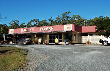
Raglan Tavern, 2022
|
|||||||||||||||
| Population | 143 (2021 census) | ||||||||||||||
| • Density | 0.2397/km2 (0.621/sq mi) | ||||||||||||||
| Postcode(s) | 4697 | ||||||||||||||
| Area | 596.6 km2 (230.3 sq mi) | ||||||||||||||
| Time zone | AEST (UTC+10:00) | ||||||||||||||
| Location |
|
||||||||||||||
| LGA(s) | Gladstone Region | ||||||||||||||
| State electorate(s) | Gladstone | ||||||||||||||
| Federal Division(s) | Flynn | ||||||||||||||
|
|||||||||||||||
Raglan is a small town and area in the Gladstone Region of Queensland, Australia. It is a rural place, meaning it's mostly countryside with farms and open spaces. In 2021, about 143 people lived in Raglan.
Contents
What is Raglan Like?
Raglan is located near Raglan Creek. This creek is part of a larger water system that flows into Keppel Bay.
Mountains Around Raglan
The area around Raglan has several mountains. These include:
- King Solomon Spur, which is 230 meters (755 feet) high.
- Marble Mountain, standing at 330 meters (1,083 feet).
- Mount Alma, the tallest at 748 meters (2,454 feet).
- Mount Bennett, at 409 meters (1,342 feet).
- Mount Bomboolba, 412 meters (1,352 feet) tall.
- Mount Despair, 290 meters (951 feet) high.
- Mount Erebus, at 350 meters (1,148 feet).
- Mount Holly, 256 meters (840 feet) high.
- Mount Wendy, standing at 657 meters (2,156 feet).
These mountains are known for having marble and calcite, which are types of rock. There's even a mine called the South Ulam mine in this area.
Getting Around Raglan
The main road, the Bruce Highway, goes through Raglan. It enters from the east, passes through the town on Raglan Street, and then leaves towards the north-west.
The North Coast railway line also runs near the highway. It has a few stations in the area:
- Epala railway station
- Amos railway station, which is no longer used.
- Raglan railway station, which serves the town.
Amos is also a small neighborhood within Raglan, located near the old Amos railway station.
There are two small airstrips in the area for planes:
- Mt Bennett station airstrip
- The Old Station airstrip
A Look Back in Time
The Raglan area was first set aside for British settlement in 1854. It was named after Fitzroy James Henry Somerset, who was a British Army leader.
Early Settlement and History
British settlement began in 1856. The area was originally home to Aboriginal people. Early interactions between settlers and Aboriginal groups were sometimes difficult. Hourigan's Creek, a local creek, was named after an early settler. Today, the Raglan Target Sports Association uses the banks of this creek for shooting sports.
Raglan became a sheep station (a large farm for sheep) in 1857. It was started by William Landsborough. The town lots for Raglan were first measured out in 1865.
Gold Rush!
In 1867, gold was discovered in Raglan! A very large gold nugget was found, measuring about 40 centimeters (16 inches) long and 10 centimeters (4 inches) wide. It weighed around 13.6 kilograms (30 pounds) and was worth a lot of money back then. About 300 gold miners were working in the Raglan goldfield at that time.
Schools in Raglan's Past
Several schools have opened and closed in the Raglan area over the years:
- Raglan Creek Provisional School first opened in 1879. It closed and reopened a few times, eventually becoming Raglan State School in 1911. It closed for good in 1996.
- Langmorn Creek Crossing Provisional School opened in 1915. It also closed and reopened, becoming Langmorn State School in 1931. It finally closed in 1962.
- Hourigan Creek State School was open from 1916 until about 1932.
Raglan Memorial Hall
The Raglan Memorial Hall was built around 1932. It was a popular place for dances until 1990. In 2002, the hall was moved to the Calliope River Historical Village, where it was officially reopened.
Who Lives in Raglan?
In 2011, the population of Raglan and the nearby area of Ambrose combined was 545 people. By 2016, Raglan alone had 146 people. In the most recent count in 2021, the population of Raglan was 143 people.
Important Historical Places
Raglan has some places that are listed as heritage sites, meaning they are important historical locations:
- Langmorn Homestead on Langmorn Road.
- Parson's Inn on Raglan Station Road.
- Raglan Homestead also on Raglan Station Road.
Learning in Raglan
There are no schools directly in Raglan today. Students usually go to primary schools in nearby towns like Marmor, Ambrose, or Bajool. For high school up to Year 10, students can go to Mount Larcom State School in Mount Larcom. For older students (up to Year 12), the closest high schools are Gladstone State High School in Gladstone or Rockhampton State High School in Rockhampton.
Local Spots and Activities
- Raglan Cemetery is located on Hourigan Creek Road.
- The Old Station Flying Club is a club for flying enthusiasts. It's located on Langmorn Road, near The Old Station airstrip.
 | Calvin Brent |
 | Walter T. Bailey |
 | Martha Cassell Thompson |
 | Alberta Jeannette Cassell |


