Rancho Bernardo, San Diego facts for kids
Quick facts for kids
Rancho Bernardo, San Diego
|
|
|---|---|
| Rancho Bernardo | |
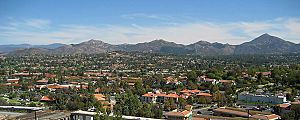
Residential areas within Rancho Bernardo
|
|
| Nickname(s):
RB
|
|
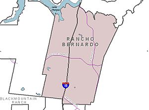
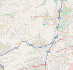
Rancho Bernardo and neighborhood boundaries
|
|
| Country | |
| State | |
| County | |
| City | |
| Area | |
| • Total | 170 km2 (65.8 sq mi) |
| Population
(2019)
|
|
| • Total | 133,481 |
| • Density | 783.5/km2 (2,029.3/sq mi) |
| Time zone | UTC-8 (Pacific Standard Time) |
| • Summer (DST) | UTC-7 (Pacific Daylight Time) |
Rancho Bernardo is a planned community located in the northern hills of San Diego, California. It's often called "RB" for short.
Contents
Exploring Rancho Bernardo's Location

Rancho Bernardo has many canyons and rolling hills. You can see large rock formations sticking out of the ground. The area is home to different types of plants, like chaparral (dense shrubs), coastal sage scrub, and grassland. There are also freshwater marshes and areas along rivers where plants grow.
This community is quite spread out. It has many shopping centers, golf courses, and office parks. It's about 20 miles (32 km) north-northeast of downtown San Diego. Nearby communities include 4S Ranch to the west, Carmel Mountain Ranch to the south, Poway to the southeast, and Escondido to the north.
Rancho Bernardo's Climate
Rancho Bernardo has a Mediterranean climate. This means it has warm, dry summers and mild winters. It doesn't rain much here, and most of the rain falls between December and March.
| Climate data for Rancho Bernardo, San Diego (normals and extremes 2000–present) | |||||||||||||
|---|---|---|---|---|---|---|---|---|---|---|---|---|---|
| Month | Jan | Feb | Mar | Apr | May | Jun | Jul | Aug | Sep | Oct | Nov | Dec | Year |
| Record high °F (°C) | 91 (33) |
90 (32) |
91 (33) |
101 (38) |
102 (39) |
101 (38) |
109 (43) |
99 (37) |
106 (41) |
102 (39) |
95 (35) |
84 (29) |
109 (43) |
| Mean daily maximum °F (°C) | 67.2 (19.6) |
66.5 (19.2) |
67.6 (19.8) |
70.4 (21.3) |
71.6 (22.0) |
76.1 (24.5) |
81.5 (27.5) |
82.8 (28.2) |
81.1 (27.3) |
77.5 (25.3) |
71.3 (21.8) |
66.1 (18.9) |
73.3 (22.9) |
| Daily mean °F (°C) | 56.6 (13.7) |
56.2 (13.4) |
58.2 (14.6) |
60.9 (16.1) |
63.5 (17.5) |
67.0 (19.4) |
72.1 (22.3) |
73.4 (23.0) |
70.7 (21.5) |
67.2 (19.6) |
60.7 (15.9) |
55.2 (12.9) |
63.5 (17.5) |
| Mean daily minimum °F (°C) | 45.9 (7.7) |
45.9 (7.7) |
48.8 (9.3) |
51.3 (10.7) |
55.3 (12.9) |
57.8 (14.3) |
62.6 (17.0) |
63.9 (17.7) |
60.3 (15.7) |
56.9 (13.8) |
50.1 (10.1) |
44.3 (6.8) |
53.6 (12.0) |
| Record low °F (°C) | 29 (−2) |
32 (0) |
35 (2) |
37 (3) |
42 (6) |
47 (8) |
53 (12) |
54 (12) |
49 (9) |
44 (7) |
36 (2) |
31 (−1) |
29 (−2) |
| Average precipitation inches (mm) | 2.79 (71) |
3.44 (87) |
2.04 (52) |
1.09 (28) |
0.38 (9.7) |
0.08 (2.0) |
0.10 (2.5) |
0.05 (1.3) |
0.17 (4.3) |
0.66 (17) |
1.08 (27) |
2.28 (58) |
14.16 (360) |
| Source: NOAA | |||||||||||||
Rancho Bernardo's History
Early History of the Area
People lived in this area for a long time, from about 850 CE to 1790 CE. The Kumeyaay people are believed to have lived here. There are also signs that the Luiseño people were present.
During a later period, there was a village called the Westwood Valley complex. It was located along a stream that sometimes dried up. The Kumeyaay likely called this village Sinyau-Pichkara. Today, this village area is under the western part of Rancho Bernardo, near Duenda and Poblado Roads.
Modern History and Development
Rancho Bernardo is part of what was once a large Mexican land grant called Rancho San Bernardo. This land was granted between 1842 and 1845.
In the 1960s, San Diego officially added Rancho Bernardo to its city limits. A company called AVCO Community Developers helped build up the area until 1984. The Rancho Bernardo Inn, a well-known hotel, opened in the middle of the development in 1963.
On October 22, 2007, a large wildfire called the Witch Creek Fire swept through Rancho Bernardo. It also affected other parts of San Diego County. The fire destroyed hundreds of homes, especially in neighborhoods that were hard for firefighters to reach. Strong winds made the fire spread very quickly. The neighborhoods most affected in Rancho Bernardo were The Trails, Montelena, and Westwood.
Economy and Local Attractions
The area around Carmel Mountain Ranch and Rancho Bernardo is a big business hub in San Diego County. It has over 6 million square feet of office space. This makes it an "I-15 edge city", which means it's a major employment center outside of a traditional downtown area.
Fun Things to Do
Every summer, Rancho Bernardo hosts RB Alive!, a carnival-style street fair. It's a fun event for the community. Rancho Bernardo is also home to the oldest working winery in the region, the Bernardo Winery. It was started in 1889 and has been owned by the same family since 1927.
Major Companies in Rancho Bernardo
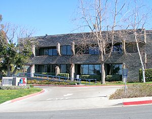
Many large companies have offices here. For example, Petco, a big pet supply company, has its main office campus in Rancho Bernardo. This campus is very large and even has a dog park! Other companies with offices in the area include Sony Electronics, Inc., Sony Interactive Entertainment, LLC, General Atomics, Broadcom, Hewlett-Packard, Microsoft, Renovate America, Teradata, LSI Corporation, BAE Systems, ASML, Northrop Grumman, and Amazon. About 50,000 people work for these companies in a large business park.
Education in Rancho Bernardo
The schools in Rancho Bernardo are part of the Poway Unified School District.
Local Schools
- Elementary Schools:
* Creekside Elementary School * Highland Ranch Elementary School * Shoal Creek Elementary School * Turtleback Elementary School * Westwood Elementary School * Chaparral Elementary School * Painted Rock Elementary School
- Middle and High Schools:
* Bernardo Heights Middle School * Rancho Bernardo High School
Famous People from Rancho Bernardo
- Bob Miller (baseball, born 1939), a former baseball pitcher who played for teams like the Los Angeles Dodgers and New York Mets.
See also
 In Spanish: Rancho Bernardo (San Diego) para niños
 | Aaron Henry |
 | T. R. M. Howard |
 | Jesse Jackson |


