
Ranco Lake facts for kids
Quick facts for kids Ranco LakeLago Ranco |
|
|---|---|

View of the lake's southeastern part from Mirador Piedra Mesa
|
|

Ranco Lake
Lago Ranco Location in Chile
|
|
| Coordinates | 40°14′51″S 72°23′07″W / 40.24750°S 72.38528°W |
| Primary inflows | Calcurrupe, Caunahue, Nilahue |
| Primary outflows | Bueno River |
| Basin countries | Chile |
| Surface area | 410 km2 (160 sq mi) |
| Max. depth | 199 m (653 ft) |
| Surface elevation | 70 m (230 ft) |
| Islands | Huapi Island, Illeifa |
| Settlements | Futrono, Lago Ranco, Llifén, Puerto Nuevo |
Ranco Lake (also known as Lago Ranco in Spanish) is a large lake found in the Ranco Province of Chile. It is the biggest lake in the Los Ríos Region and the fourth largest lake in all of Chile.
The lake is managed by three different areas called communes: La Unión, Futrono, and Lago Ranco. Ranco Lake has several islands, with Huapi Island being the largest. Another island, Illeifa Island, is privately owned.
Contents
What Does Ranco Lake Look Like?
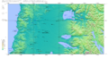
The western part of Ranco Lake is mostly round, like a circle. The eastern part has deep inlets, which are like long, narrow arms of the lake reaching into the land.
The lake is located in the Andean precordillera. This is a special area between the flat Chilean Central Valley and the tall Andes mountains.
Unlike many other big lakes nearby, Ranco Lake does not have a large, clear volcano right next to it.
Plants and Animals in Ranco Lake
An unusual plant called Limnobium laevigatum can be found in Ranco Lake. This is one of the southernmost places in Chile where this plant grows. It is considered an invasive species, meaning it can spread quickly and affect other plants.
How Ranco Lake Was Formed
Millions of years ago, during a time called the Miocene epoch, the area where Ranco Lake is now was connected to the Pacific Ocean. It was like a bay of the ocean.
During this period, special rocks with sea fossils were formed in the lake area. These rocks are known as Estratos de Lago Ranco.
Later, during the Ice Ages (called quaternary glaciations), a huge glacier covered the lake area. This glacier was part of the Patagonian Ice Sheet. As the glacier moved and melted, it left behind semicircular hills of rock and dirt, called moraines, around the western shore of the lake.
Images for kids
-
Topography of the region. The Puyehue-Cordón Caulle massif is located between Ranco and Puyehue Lake

See also
 In Spanish: Lago Ranco para niños
