
Flinders Chase National Park facts for kids
Quick facts for kids Flinders Chase National ParkSouth Australia |
|
|---|---|
|
IUCN Category II (National Park)
|
|

Remarkable Rocks, in the southern part of the park
|
|

Flinders Chase National Park
Location in South Australia
|
|
| Nearest town or city | Kingscote |
| Established | 1919 1972 (national park) |
| Area | 326.61 km2 (126.1 sq mi) |
| Managing authorities | Department for Environment and Water |
| See also | Protected areas of South Australia |
Flinders Chase National Park is a special protected area in South Australia, Australia. It is located on the western side of Kangaroo Island. This park is about 177 kilometers (110 miles) west-southwest of Adelaide, the state capital. It is also about 110 kilometers (68 miles) west of Kingscote, the main town on Kangaroo Island.
The park is a safe home for many endangered species. It also features amazing rock formations shaped by nature. Flinders Chase was the second national park ever created in South Australia.
The park is made up of three main parts:
- A coastal area around Cape du Couedic in the southwest.
- The Gosse Lands in the middle of the island's west end.
- The former Cape Borda Lightstation area in the northwest.
Contents
Where is Flinders Chase National Park?
Flinders Chase National Park is found at the northwest end of Kangaroo Island. It is located within the areas known as Flinders Chase, Gosse, and Karatta.
What Kind of Protected Area Is It?
Flinders Chase National Park is a special type of protected area. It is classified as an IUCN Category II park. This means it is mainly set aside to protect large natural areas and their wildlife. It also allows for activities like recreation and tourism.
History of the Park
The park first became a protected area on October 16, 1919. It was called a 'flora and fauna reserve' back then. This was done to protect and help Australian animals and plants grow.
In 1972, it officially became a national park. This happened when the National Parks and Wildlife Act 1972 was passed. This new law replaced older ones, including the 1919 act.
Later, in 1993, a part of the park was changed. About 416 square kilometers (161 square miles) was taken out of the national park. This area became the Ravine des Casoars Wilderness Protection Area. This new area was created to protect its wild nature even more strictly.
A Safe Home for Wildlife
Since it was created, Flinders Chase National Park has been a safe place for animals. Some endangered species were even brought here from the mainland in the 1920s and 1930s.
Many animals were introduced in the 1940s. These included Koalas (in 1923) and Platypus (in 1928). Today, you can still see most of these animals in the park. It's common to spot Kangaroos, Goannas, and Echidnas.
Little Penguins in the Park
Little penguins were seen in Flinders Chase in the 1920s, 1930s, 1940s, and 1950s. Sadly, it is thought that these penguin groups have now disappeared from the park. One reason might be the increase in long-nosed fur seal populations. These seals became more common after commercial sealing stopped. In 1886, little penguins were even seen at Admiral's Arch.
Amazing Rock Formations
The park is home to two amazing natural rock formations. These have been named geological monuments by the Geological Society of Australia. They are Cape du Couedic and Remarkable Rocks.
Remarkable Rocks are unique rock shapes that look like sculptures. They are balanced carefully on top of a granite outcrop. Many visitors say they look like artworks by famous artists.
Bushfires in the Park
Flinders Chase National Park has faced challenges from bushfires.
- In December 2007, lightning strikes caused a large fire. It burned over 63,000 hectares (156,000 acres) of the park. Firefighters worked hard to put it out.
- In 2019-2020, another big fire, called the Ravine fire, burned at least 15,000 hectares (37,000 acres) in the park.
Gallery
-
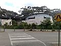
Flinders Chase visitors centre
-
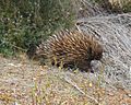
Echidna at Flinders Chase National Park
-
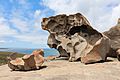
Remarkable Rocks
-
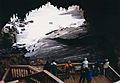
Admirals Arch
-
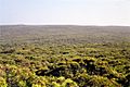
View from Bunker Hill lookout


Images for kids
-
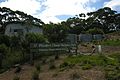
Flinders Chase Visitor Centre

See also
 In Spanish: Parque nacional Flinders Chase para niños
