
Reservoir Creek facts for kids
Quick facts for kids Reservoir Creek |
|
|---|---|

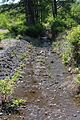
Reservoir Creek looking upstream in its lower reaches
|
|
| Physical characteristics | |
| Main source | valley on Little Wilkes-Barre Mountain in Newport Township, Luzerne County, Pennsylvania between 1,000 and 1,020 feet (300 and 310 m) |
| River mouth | South Branch Newport Creek in Newport Township, Luzerne County, Pennsylvania 643 ft (196 m) 41°10′37″N 76°01′41″W / 41.17684°N 76.02796°W |
| Length | 1.6 mi (2.6 km) |
| Basin features | |
| Progression | South Branch Newport Creek → Newport Creek → Susquehanna River → Chesapeake Bay |
Reservoir Creek is a small stream in Luzerne County, Pennsylvania, in the United States. It flows into another stream called South Branch Newport Creek. The creek is about 1.6 miles (2.6 km) long and runs through Newport Township. You can find it on maps from the United States Geological Survey (USGS) for the Nanticoke area.
Most of the land around the creek is covered by forests. But there are also some areas with buildings, farms, and land that has been changed by human activity. The main types of rock found here are the Llwellyn, Mauch Chunk, Pottsville, and Pocono Formations. The soils are mostly Lackawanna-Arnot-Morris and Udorthents-Urban Land-Volusia series. The Pennsylvania Department of Environmental Protection says that the creek's water quality is not as good as it should be.
Contents
Where Reservoir Creek Flows
Reservoir Creek starts in a valley on Little Wilkes-Barre Mountain in Newport Township.
Creek's Journey
It flows east for a short distance, then enters a small pond. After the pond, it turns north. The creek then leaves Little Wilkes-Barre Mountain and turns north-northwest. It flows along the edge of the village of Wanamie. After a little while, it turns north again and joins South Branch Newport Creek.
Water Quality of Reservoir Creek
The entire length of Reservoir Creek has water quality issues. The Pennsylvania Department of Environmental Protection says it is affected by abandoned mine drainage.
Why the Water is Affected
This means that water from old, unused mines flows into the creek. This mine water can change the water's pH (how acidic or basic it is) and add a lot of silt (fine dirt or mud). These changes make the water unhealthy for plants and animals.
Land and Rocks Around the Creek
The land around the mouth of Reservoir Creek is about 643 feet (196 meters) above sea level. Where the creek begins, the land is higher, between 1000 and 1020 feet (305 to 311 meters) above sea level.
Rock Formations
The lower parts of Reservoir Creek flow over rocks from the Llwellyn Formation. Further upstream, there's a thin layer of Pottsville Formation rock. The upper parts of the creek are on rocks from the Mauch Chunk Formation. Just south of the creek's upper areas, you can find rocks from the Pocono Formation.
Soil Types
The soil near the lower parts of Reservoir Creek is called the Udorthents-Urban Land-Volusia series. However, the soil in the creek's upper areas is the Lackawanna-Arnot-Morris series.
Changes to the Creek's Path
At some point in the past, the path of Reservoir Creek was changed from where it naturally flowed. A part of Little Wilkes-Barre Mountain is also in the area that drains into Reservoir Creek.
The Reservoir Creek Area
Reservoir Creek is completely located within the Nanticoke map area of the United States Geological Survey.
Land Use Around the Creek
Most of the land near Reservoir Creek is forested. However, there are some small areas used for agriculture and some "disturbed" land. There are also some developed areas with buildings in the village of Wanamie, which is close to where the creek joins South Branch Newport Creek.
Protected Land
A part of Reservoir Creek flows through a 300-acre piece of land that is protected by the North Branch Land Trust. This area is mainly a forest with both hardwood trees and softwood conifers.
The Old Wanamie Reservoir
There used to be a reservoir (a large artificial lake) called the Wanamie Reservoir on Reservoir Creek. It was held back by the Wanamie Dam and was about 15 to 20 acres in size. However, the dam was removed in 2007 because it was unsafe. The reservoir was also drained that same year. You can still find the remains of the dam in the area.
History of Reservoir Creek
Reservoir Creek was officially added to the Geographic Names Information System on August 1, 1989. Its special ID number in that system is 1212408.
Mining in the Area
In the past, coal mining took place near Reservoir Creek.
Creek Rerouting Project
In 2014, the Pennsylvania Department of Environmental Protection asked for $114 million from a program that helps clean up old mine sites. One project they wanted to do was to move a section of Reservoir Creek. This was to prevent flooding in certain areas and to close several old mine openings nearby. This project covers a 42-acre area and was expected to cost less than $1,000,000. The plan was to move a 1320-foot (about 400-meter) part of the creek into a more stable path and then fill in the old, unstable path.
Images for kids
-
Reservoir Creek looking upstream in its lower reaches
