
Rheinfelden (Aargau) facts for kids
Quick facts for kids
Rheinfelden
|
||
|---|---|---|
 |
||
|
||

Rheinfelden
Location in Switzerland

Rheinfelden
Location in Canton of Aargau
|
||
| Country | Switzerland | |
| Canton | Aargau | |
| District | Rheinfelden | |
| Area | ||
| • Total | 16.02 km2 (6.19 sq mi) | |
| Elevation | 280 m (920 ft) | |
| Population
(Dec 2020 )
|
||
| • Total | 13,551 | |
| • Density | 845.88/km2 (2,190.8/sq mi) | |
| Postal code |
4310
|
|
| Surrounded by | Kaiseraugst, Magden, Möhlin, Olsberg, Rheinfelden (DE-BW), Schwörstadt (DE-BW) | |

|
Lordship (County?) of Rheinfelden
Herrschaft (Grafschaft?) Rheinfelden
|
|||||||||
|---|---|---|---|---|---|---|---|---|---|
| 10th century–1080 | |||||||||
| Status | State of the Holy Roman Empire | ||||||||
| Capital | Rheinfelden | ||||||||
| Government | Principality | ||||||||
| Historical era | Middle Ages | ||||||||
|
• First settled
|
Middle Stone Age (10,000 BP) | ||||||||
|
• Established
|
10th century | ||||||||
|
• Inherited by Zähringen
|
1080 | ||||||||
|
|||||||||
|
Imperial City of Rheinfelden
Reichsstadt Rheinfelden
|
|||||||||
|---|---|---|---|---|---|---|---|---|---|
| 1225–1330 | |||||||||
| Status | Free Imperial City of the Holy Roman Empire | ||||||||
| Capital | Rheinfelden | ||||||||
| Government | Republic | ||||||||
| Historical era | Middle Ages | ||||||||
|
• Zähringen ducal
line extinct |
1218 |
||||||||
|
• Gained Reichsfreiheit
|
1225 | ||||||||
|
• Joined Habsburg
Further Austria |
1330 | ||||||||
|
|||||||||
Rheinfelden (which means "fields of the Rhine") is a city in the canton of Aargau in Switzerland. It's the main town of the Rheinfelden district. This city is located about 15 kilometers (9 miles) east of Basel.
Rheinfelden sits right on the High Rhine river. It's famous for being home to Feldschlösschen, which is the most popular beer company in Switzerland. There's another city also called Rheinfelden just across the river in Germany. These two cities used to be one until Napoleon Bonaparte set the Germany–Switzerland border on the Rhine in 1802. Even today, they share many social and economic ties.
Contents
- Exploring Rheinfelden's Geography
- A Look at Rheinfelden's History
- City Leaders: Mayors of Rheinfelden
- Rheinfelden's Coat of Arms
- People and Population
- Important Buildings and Sites
- Rheinfelden's Economy
- Religion in Rheinfelden
- Transportation Links
- Education in Rheinfelden
- Famous People from Rheinfelden
- Rheinfelden's Weather
- See also
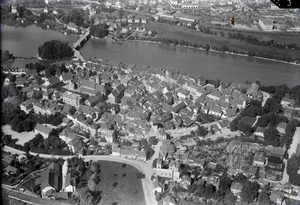
Exploring Rheinfelden's Geography


The old part of Rheinfelden is on the left bank of the Rhine river. Here, the river splits into two parts around a small island called "Inseli." This island is about 150 meters (490 feet) long. Downstream from the Inseli and the Rheinbrücke (Rhine bridge), the river gets very deep, about 30 meters (98 feet). This creates a strong, dangerous whirlpool known as the St-Anna-Loch.
South of the town, you'll find the wooded hills of the Tafeljura. These hills include the Steppberg (395 meters or 1,296 feet above sea level) and the "Berg" (427 meters or 1,401 feet). Between these hills are deep valleys carved by the Magdenerbach stream.
Rheinfelden covers an area of about 16.12 square kilometers (6.22 square miles). About 20.7% of this land is used for farming, and 50% is covered by forests. Around 22.6% of the land has buildings or roads, while 6.7% is unproductive land. The highest point in Rheinfelden is on the "Berg" hill at 427 meters (1,401 feet). The lowest point is on the Rhine river at 270 meters (886 feet).
Rheinfelden's neighbors include Kaiseraugst to the west, Olsberg to the southwest, Magden to the south, and Möhlin to the east. Across the river in Germany is Rheinfelden, Baden-Württemberg.
A Look at Rheinfelden's History

People first lived in the Rheinfelden area around 10,000 years ago, during the Middle Stone Age. They lived in a natural cave called the "Hermitage." Later, around 45 BC, the Romans built their first town in Switzerland, Augusta Raurica, a few kilometers west of Rheinfelden. There was also a large farm estate in the Rheinfelden plains.
Rheinfelden was first mentioned around 851 as Rifelt. In the 10th century, the Fricktal area, where Rheinfelden is located, was part of the Kingdom of Burgundy. The von Wetterau family was given control of Rheinfelden and later became known as the Counts of Rheinfelden. They built a strong fort called "Stein" on the strategically important Inseli island. The most famous person from this family was Rudolf of Rheinfelden, who was a powerful duke and even tried to become the German king.
After Rudolf died in 1080, his lands were inherited by Berthold II of Zähringen. His son, Conrad, gave Rheinfelden its market rights in 1150. This made Rheinfelden the oldest city founded by the Zähringen family in Switzerland, and the oldest city in Aargau. Conrad also built the first bridge across the Rhine between Konstanz and Strasbourg here.
In 1218, the Zähringen family line ended. In 1225, Rheinfelden became a Imperial City, meaning it was free and answered directly to the Holy Roman Emperor.
However, in 1330, the city chose to join the Habsburg family's lands, becoming part of Further Austria. The city faced many conflicts over the centuries. In 1445, during the Old Zürich War, rebels destroyed the castle on the "Inseli." After a long siege, Rheinfelden returned to Austrian control in 1449.
The 17th century was a very difficult time for Rheinfelden due to constant wars. The city was affected by the Rappenkrieg, a peasant uprising. Between 1633 and 1638, the Thirty Years' War heavily impacted the area. In 1638, a major battle, the Battle of Rheinfelden, took place here. Protestant troops led by Bernhard of Saxe-Weimar fought against larger Imperial and Bavarian armies. After an initial loss, Bernhard's forces surprised the enemy and won the second part of the battle.
Later, in 1678, French troops attacked the city. In 1745, during the War of the Austrian Succession, the French built a fortress on the island and damaged parts of the city wall. On July 17, 1796, French troops again occupied and looted Rheinfelden during the French Revolutionary Wars.
In 1797, due to the Treaty of Campo Formio, the Fricktal area became a French protectorate. In 1802, Rheinfelden was made the capital of the new Canton of Fricktal. In August of that year, it officially joined the Helvetic Republic, which made it part of Switzerland. In 1803, Napoleon Bonaparte dissolved the canton of Fricktal. Since then, Rheinfelden has been the capital of its own district within the canton of Aargau. At this time, the parts of the city on the German side of the Rhine lost their independence and became Rheinfelden, Germany.
City Leaders: Mayors of Rheinfelden
The mayor is the head of the city government. Here are some of the people who have served as mayor of Rheinfelden:
- 1945: Eugen Walz
- 1945–1946: Franz Fischer
- 1946–1948: Alois Maier
- 1948–1988: Herbert King
- 1988–2012: Eberhard Niethammer
- since 2012: Klaus Eberhardt (born 1956)
Rheinfelden's Coat of Arms
The city's coat of arms shows a shield with six horizontal stripes, alternating between gold (yellow) and red. On top of these stripes are three golden stars.
People and Population
Rheinfelden has a population of about 10,881 people (as of December 2007). About 27.6% of the people living here are from other countries. Most people in Rheinfelden speak German (82.9%). Other languages spoken include Italian (3.8%) and Serbo-Croatian (2.0%).
The city has a mix of ages. About 9.1% of the population are children aged 0-9, and 10.4% are teenagers aged 10-19.
_02.jpg)
In 2000, there were 4,953 homes and apartments in Rheinfelden. On average, there were 2.1 people living in each home. In 2008, about 15.7% of the homes were single-family houses.
In the 2007 federal election, the most popular political party was the SP, which received 27.64% of the votes. The SVP was second with 26.15%.
Here's how Rheinfelden's population has changed over time:
| Historical population | ||
|---|---|---|
| Year | Pop. | ±% |
| 1788 | 1,226 | — |
| 1850 | 1,910 | +55.8% |
| 1900 | 3,349 | +75.3% |
| 1950 | 4,550 | +35.9% |
| 1970 | 6,866 | +50.9% |
| 2000 | 10,637 | +54.9% |
Important Buildings and Sites
The entire old town of Rheinfelden is considered a Swiss heritage site. This means it's a very important historical area. There are seven specific sites in Rheinfelden that are listed as heritage sites of national significance.
These include:
- Two churches: the Christian Catholic collegiate church of St. Martin and the Johanniter Chapel.
- Three old fortifications: the Heimenholz and Pferrichgraben (parts of old Roman defenses) and the entire medieval city wall.
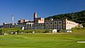
- Two other buildings: the Feldschlösschen brewery and the former Gasthof (hotel and restaurant) zum goldenen Adler.
-
Feldschlösschen brewery
-
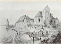
Johanniter Order house with chapel to the right
-
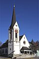
Protestant Church of Rheinfelden
-
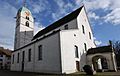
St. Martin's Church


.jpg)
Rheinfelden's Economy
In 2007, Rheinfelden had an unemployment rate of 3.83%. In 2005, about 40 people worked in farming. A larger number, 1,313 people, worked in the manufacturing and industry sector. The biggest group, 4,420 people, worked in the service sector (like shops, offices, and healthcare).
Many people who live in Rheinfelden work outside the city (about 63.5%). However, many people also travel into Rheinfelden for work. About 26.3% of workers use public transportation to get to work, and 39.2% use a private car.
Religion in Rheinfelden
Based on the 2000 census, about 36.1% of the population were Roman Catholic. About 33.0% belonged to the Swiss Reformed Church (a Protestant church). There were also about 2.67% of the population who belonged to the Christian Catholic faith.
Transportation Links
Rheinfelden is located on the Bözberg railway line. It has two train stations: Rheinfelden and Rheinfelden Augarten. These stations serve local and regional trains, connecting the city to other places.
Education in Rheinfelden
Many adults in Rheinfelden have a good education. About 73.6% of people aged 25–64 have completed either advanced secondary education or higher education (like university).
In the 2008/2009 school year, there were 667 students in primary school and 251 students in secondary school. There were also 386 students attending university-level schooling.
Rheinfelden has a public library called the Stadtbibliothek Rheinfelden. In 2008, the library had over 16,442 books and other media. It loaned out 58,291 items that year.
Famous People from Rheinfelden
Rheinfelden has been home to several notable individuals, including historical figures and sports stars.

- Matilda of Habsburg (1253–1304): A duchess of Bavaria.
- Hedwig of Habsburg (c. 1260–1303): A margravine of Brandenburg.
- Rudolf II, Duke of Austria (c. 1270–1290): A Duke of Austria and Styria.
- Jacob Sprenger (1436/1438–1495): A Dominican Friar.
- Ernst Hermann Joseph Münch (1798–1841): A historian.
- Jakob Christof Rad (1799–1871): A physician and industrial manager.
- Andreas Kyburz (born 1988): A Swiss orienteering competitor.
Sports Stars
- Ivan Rakitić (born 1988): A Croatian professional footballer who plays for Spanish club Sevilla.
- Yannick Käser (born 1992): A Swiss breaststroke swimmer.
- Alexander Ursenbacher (born 1996): A Swiss professional snooker player.
- Eray Cömert (born 1998): A footballer who has played many games, including for the Swiss national team.
Rheinfelden's Weather
| Climate data for Rheinfelden (1961–1990) | |||||||||||||
|---|---|---|---|---|---|---|---|---|---|---|---|---|---|
| Month | Jan | Feb | Mar | Apr | May | Jun | Jul | Aug | Sep | Oct | Nov | Dec | Year |
| Mean daily maximum °C (°F) | 2.9 (37.2) |
5.5 (41.9) |
9.9 (49.8) |
14.5 (58.1) |
18.9 (66.0) |
22.0 (71.6) |
24.7 (76.5) |
23.9 (75.0) |
20.6 (69.1) |
14.6 (58.3) |
7.7 (45.9) |
3.8 (38.8) |
14.1 (57.4) |
| Daily mean °C (°F) | −0.1 (31.8) |
1.5 (34.7) |
4.6 (40.3) |
8.3 (46.9) |
12.5 (54.5) |
15.8 (60.4) |
18.1 (64.6) |
17.3 (63.1) |
14.1 (57.4) |
9.7 (49.5) |
4.2 (39.6) |
0.9 (33.6) |
8.9 (48.0) |
| Mean daily minimum °C (°F) | −3.0 (26.6) |
−1.9 (28.6) |
0.2 (32.4) |
3.0 (37.4) |
7.1 (44.8) |
10.4 (50.7) |
12.3 (54.1) |
11.9 (53.4) |
9.3 (48.7) |
5.9 (42.6) |
1.0 (33.8) |
−1.9 (28.6) |
4.5 (40.1) |
| Average precipitation mm (inches) | 74 (2.9) |
68 (2.7) |
69 (2.7) |
78 (3.1) |
97 (3.8) |
100 (3.9) |
86 (3.4) |
102 (4.0) |
75 (3.0) |
66 (2.6) |
79 (3.1) |
80 (3.1) |
974 (38.3) |
| Average snowfall cm (inches) | 13 (5.1) |
13 (5.1) |
3 (1.2) |
0 (0) |
0 (0) |
0 (0) |
0 (0) |
0 (0) |
0 (0) |
0 (0) |
4 (1.6) |
8 (3.1) |
41 (16) |
| Average precipitation days (≥ 1.0 mm) | 12.2 | 10.9 | 12.4 | 12.7 | 13.4 | 11.9 | 10.4 | 11.5 | 9.2 | 8.9 | 11.4 | 11.7 | 136.6 |
| Average snowy days (≥ 1.0 cm) | 3.4 | 2.9 | 0.9 | 0.1 | 0.0 | 0.0 | 0.0 | 0.0 | 0.0 | 0.0 | 1.2 | 2.4 | 10.9 |
| Average relative humidity (%) | 83 | 79 | 75 | 71 | 72 | 72 | 71 | 74 | 79 | 83 | 84 | 83 | 77 |
| Source: MeteoSwiss | |||||||||||||
See also
 In Spanish: Rheinfelden (Argovia) para niños
