
Ringgenberg facts for kids
Quick facts for kids
Ringgenberg
|
||
|---|---|---|
 |
||
|
||

Ringgenberg
Location in Switzerland

Ringgenberg
Location in Canton of Bern
|
||
| Country | Switzerland | |
| Canton | Bern | |
| District | Interlaken-Oberhasli | |
| Area | ||
| • Total | 8.73 km2 (3.37 sq mi) | |
| Elevation | 1,103 m (3,619 ft) | |
| Population
(Dec 2020 )
|
||
| • Total | 2,588 | |
| • Density | 296.45/km2 (767.8/sq mi) | |
| Postal code |
3852
|
|
| Localities | Ringgenberg, Goldswil | |
| Surrounded by | Bönigen, Habkern, Interlaken, Niederried bei Interlaken, Unterseen | |

Ringgenberg is a charming village and a municipality in Switzerland. It's located in the Bern area, specifically in the Interlaken-Oberhasli district. Sometimes, people call it Ringgenberg BE to avoid confusing it with other places.
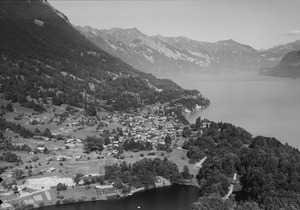
The municipality includes both the village of Ringgenberg and the nearby village of Goldswil. You can find Ringgenberg right on the northern shore of Lake Brienz. It's famous for its small church, which was built in the 1600s on top of an old castle's ruins.
Ringgenberg and Goldswil are part of a larger group of towns around Interlaken, which had about 23,300 people living there in 2014.
Contents
A Look Back: Ringgenberg's History


The very first signs of people living here are ancient graves from the neolithic period (Stone Age). These were found in Ringgenberg village and at Goldswil-Mätteli.
The village's original name was Rinchenwile, first mentioned in records in 1240. This name came from an old German name, Rinco, and meant "little town." Later, it combined with "burg" (castle) to become Ringgenberg.
Around 1230, a nobleman named Kuno von Brienz was put in charge of the Lake Brienz area by the German Emperor. He built the castle at Ringgenberg. His family then took the name Ringgenberg. One famous member was Johann von Ringgenberg, known as a knight who was good with both a sword and music! His songs were even collected in a book around 1300.
During the 1200s, the Ringgenberg family grew more powerful. But their castle started to fall apart in the mid-1300s. In 1351, part of their land was sold. Then, in 1381, soldiers from the Canton of Uri burned and robbed Ringgenberg castle. The count, Petermann von Ringgenberg, was even taken prisoner.
By 1386, the castle and lands were given to Bern, a powerful city. But Bern didn't have enough money to rebuild the castle. So, parts of the castle and village were sold to a nearby monastery in 1411 and 1439. Bern got the land back in 1445, but lost it again in 1457.
In 1528, Bern adopted a new Christian faith called the Protestant Reformation. They tried to make everyone in the Bernese Oberland (the region where Ringgenberg is) follow this new faith. Ringgenberg and other villages tried to fight back, but they didn't win. After Bern took control, they closed the monastery and took all its lands. Ringgenberg then became part of Bern's area called the bailiwick of Interlaken.
The beautiful church you see today was built in 1670. It stands on a hill where the old castle ruins were, between the village and the lake.
In 1853, the two separate villages, Goldswil and Ringgenberg, officially joined together. A small lake called Burgseeli is located between them.
Travel and tourism became important for Ringgenberg. A road was built along Lake Brienz in 1848, connecting the village to others. In 1888, a harbor was built for steamships, helping tourists visit the village's spa, which opened in 1870. In 1916, a railway line called the Brünig railway line was finished, passing through the village.
Today, Ringgenberg's economy relies on tourism, construction, and a local quarry. Many people also travel to Interlaken for work.
Ringgenberg's Location and Landscape

Ringgenberg covers an area of about 8.7 square kilometers (3.4 square miles). A big part of this land, about 64%, is covered by forests. About 19% is used for farming, and 11.7% has buildings or roads. A small amount, less than 1%, is rivers or lakes, and about 3.8% is land that can't be used for farming or building.
The municipality is located northeast of Interlaken, right on the shores of Lake Brienz. It includes the villages of Ringgenberg and Goldswil, plus some mountain camps.
In 2010, Ringgenberg became part of a new administrative area called Verwaltungskreis Interlaken-Oberhasli.
The Ringgenberg Coat of Arms
The coat of arms for Ringgenberg shows a silver buckle on a red background. Below it are six silver hills. This design represents the municipality.
People of Ringgenberg
_183.JPG)
Ringgenberg has a population of about 2,588 people (as of December 2010). About 9% of the people living here are from other countries. Over the past 10 years (2000-2010), the population grew by about 7.2%.
Most people in Ringgenberg (about 94%) speak German as their main language. Other languages spoken include Albanian and English.
In 2008, the population was almost evenly split between men (49.6%) and women (50.4%). About 30.5% of the people living in Ringgenberg in 2000 were also born there.
Children and teenagers (ages 0-19) make up about 21.5% of the population. Adults (20-64) are 60%, and seniors (over 64) are 18.5%.
Important Historical Sites

The church and the ruins of Ringgenberg Castle are very important. They are listed as a single heritage site of national significance in Switzerland. The entire village of Ringgenberg is also part of the Inventory of Swiss Heritage Sites, meaning it's a special place with historical value.
Ringgenberg's Economy
In 2011, the unemployment rate in Ringgenberg was low, at 1.9%. In 2008, about 724 people worked in the municipality.
- Primary Sector: This includes jobs like farming and forestry. About 39 people worked in this area.
- Secondary Sector: This covers jobs in manufacturing, mining, and construction. About 198 people worked here, with many in construction.
- Tertiary Sector: This includes jobs in services like shops, hotels, restaurants, education, and healthcare. About 487 people worked in this sector.
Many people who live in Ringgenberg travel to other towns for work, especially to Interlaken. About 13% of workers use public transport, and 52% use a private car.
Religion in Ringgenberg

According to the 2000 census, most people in Ringgenberg (about 73.5%) belonged to the Swiss Reformed Church (a Protestant church). About 11.3% were Roman Catholic. There were also smaller numbers of people belonging to other Christian churches, Islam, Buddhism, and Hinduism. About 4.9% of the population did not belong to any church.
Education in Ringgenberg
Many people in Ringgenberg have a good education. About 43.6% have finished high school, and 9.2% have gone on to higher education, like university.
The school system in Bern Canton starts with one year of kindergarten. Then, students go to six years of primary school. After that, they have three years of lower secondary school, where they are grouped by their abilities. After lower secondary, students can continue their education or start an apprenticeship.
In the 2010-2011 school year, Ringgenberg had 308 students. This included 30 kindergarten students, 172 primary school students, and 90 lower secondary students. Some students also attended private or special schools.
Getting Around: Transport
The Ringgenberg railway station is on the Brünig railway line. You can catch a train every hour between Interlaken and Meiringen. There's also an hourly post bus that connects Interlaken, Goldswil, and Ringgenberg.
Fun Fact: The Planet Trail
Ringgenberg is also the starting point for the Ringgenberg-Goldswil Planetenweg, which means "Planet Trail." It's a walking path that shows a tiny model of our Solar System. The Sun and planets are placed along the route, connecting nearby towns, at a scale of 1 to 1,000,000,000!
Images for kids
-
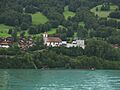
Ringgenberg Church on Lake Brienz.
-
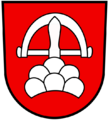
The coat of arms of Ringgenberg.
See also
 In Spanish: Ringgenberg para niños
