
Ritzville, Washington facts for kids
Quick facts for kids
Ritzville, Washington
|
|
|---|---|
| City of Ritzville | |
.jpg)
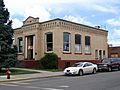
Gritman Building, downtown Ritzville
|
|

Location of Ritzville, Washington
|
|
| Country | United States |
| State | Washington |
| County | Adams |
| Area | |
| • Total | 1.75 sq mi (4.53 km2) |
| • Land | 1.75 sq mi (4.53 km2) |
| • Water | 0.00 sq mi (0.00 km2) |
| Elevation | 1,818 ft (554 m) |
| Population
(2020)
|
|
| • Total | 1,767 |
| • Density | 1,010/sq mi (390.1/km2) |
| Time zone | UTC-8 (Pacific (PST)) |
| • Summer (DST) | UTC-7 (PDT) |
| ZIP code |
99169
|
| Area code | 509 |
| FIPS code | 53-58725 |
| GNIS feature ID | 1512607 |
| Website | City of Ritzville |
Ritzville is a city located in Adams County, Washington, in the United States. In 2020, about 1,767 people lived there. It's the main city of Adams County, where the county government is located. Ritzville is also part of a larger area that includes Othello and Moses Lake.
Contents
History of Ritzville
The first person to settle in the area that would become Ritzville was William McKay in 1880. The town was later named after Phillip Ritz, who had settled nearby two years earlier. By December 1880, the town's layout was planned by John W. Sprague for his company, the Northern Pacific Railway.
In 1881, McKay built the first house in the town. The Northern Pacific Railway was building its tracks nearby. McKay's home became a temporary hotel for the workers and travelers.
Growth with the Railroad
The railroad brought many new settlers to the area. In the summer of 1881, McKay opened the first store. The railroad built a depot nearby, which also served as a hotel, theater, and meeting hall. At that time, the small village had about 50 people. The school was just a simple lean-to against a house.
The town's water came from the railroad's water tank. People didn't think they could find water underground. The first church services in Adams County were held in Ritzville in April 1882 at McKay's home. Soon after, the First Congregational Church was formed, and a church building was built in 1885.
The post office was set up in 1883 by J.L. Johnson, who also bought McKay's store. Many more businesses soon opened in town. As the 1880s continued, Ritzville became an important place for shipping wheat in the "Big Bend Country" region, and it kept growing.
Finding Water and Facing Challenges
When the town's water supply from the railroad tank started to run low, people began looking for underground water. At first, they found no water. But finally, a well was dug about 1 mile (1.6 km) east of the town. Most landowners agreed to move closer to the well. However, a large hotel could not be moved. Luckily, water was eventually found at the original town site, so the town didn't have to move.
By 1887, Ritzville had grown quite a bit. It had:
- Three general stores
- One drug store
- One saloon
- Two blacksmith shops
- Two lumber yards
- Two livery stables (places to keep horses)
- One harness shop
- Two hotels
- A large, two-story wooden schoolhouse with 100 students
Fires and Rebuilding
On June 6, 1888, a fire started by a faulty chimney destroyed almost all of the business area of town. Ritzville didn't have a fire department then, so citizens couldn't stop the flames effectively.
Rebuilding started quickly. The town's first brick building was constructed in 1889 by N.H. Greene, who was the town's first mayor. This building still stands today and is part of the Ritzville Historic District.


After the fire, Ritzville became an official town in 1888. It was officially re-incorporated as a city on July 17, 1890, after Washington became a state. The first bank, The Adams County Bank (later First National Bank), opened in April 1891. After another downtown fire in 1894, a water system was installed for $20,000. The first permanent Adams County courthouse was also built in 1892.
Booming into the 20th Century
After a tough economic time in 1893, Ritzville saw another boom in 1898. Demand for property increased, and many buildings were constructed. Telephone service began in August 1899. By the year 1900, the population was over 1,200 people.
The town finally got a volunteer fire department in 1901, with equipment paid for by the citizens. Also in 1901, Ritzville earned the title of the greatest wheat shipping point in the world. Between August 1901 and August 1902, nearly 2 million bushels of wheat were brought to Ritzville warehouses for shipping. Almost 2,000 train cars of wheat and flour were sent out. These numbers were even higher in 1902.
On January 17, 1902, Ritzville got electricity for the first time, powered by a steam-powered generator. The Chamber of Commerce was formed in 1903. The next year, the courthouse was made twice as big. The city received a Carnegie Library in 1907, which was the only one in Adams County. It still serves as the town's library today.
Modern Times
By the time of The Great Depression (a period of severe economic downturn in the 1930s), growth in Ritzville had slowed down. It settled into being a small town. In the 1960s, Interstate 90 was built around the south side of town. This highway replaced U.S. Route 10 and moved traffic away from downtown. The town's slower development since then has helped keep its unique charm. This led to the creation of The Ritzville Historic District in 1990.
Much of Ritzville's history is shown in the A.M. Kendrick collection of images. This collection shows daily life in eastern Washington state. It was originally kept by the Adams County Rural Library District No. 2 (formerly Ritzville Public Library) and is now available digitally in the Washington State Digital Archives.
Geography and Climate
.jpg)
Ritzville is located along Paha Creek, at the northern end of the Paha Coulee. It's about 53 miles (85 km) southwest of Spokane on Interstate 90 and U.S. Route 395.
The United States Census Bureau states that the city covers a total area of 1.70 square miles (4.40 square kilometers), and all of it is land.
Ritzville's Climate
Ritzville has a semi-arid climate, which means it's quite dry. The average rainfall each year is about 11.9 inches (30.2 cm).
- The average temperature in January is about 27°F (-3°C).
- The average temperature in July is about 69°F (21°C).
- The city gets just under 20 inches (50 cm) of snow on average each year.
| Climate data for Ritzville, Washington (1991–2020 normals, extremes 1916–present) | |||||||||||||
|---|---|---|---|---|---|---|---|---|---|---|---|---|---|
| Month | Jan | Feb | Mar | Apr | May | Jun | Jul | Aug | Sep | Oct | Nov | Dec | Year |
| Record high °F (°C) | 60 (16) |
66 (19) |
77 (25) |
92 (33) |
99 (37) |
110 (43) |
111 (44) |
112 (44) |
103 (39) |
93 (34) |
70 (21) |
62 (17) |
112 (44) |
| Mean daily maximum °F (°C) | 35.8 (2.1) |
41.8 (5.4) |
51.0 (10.6) |
59.7 (15.4) |
69.1 (20.6) |
76.2 (24.6) |
86.7 (30.4) |
86.1 (30.1) |
76.6 (24.8) |
61.5 (16.4) |
45.2 (7.3) |
35.2 (1.8) |
60.4 (15.8) |
| Daily mean °F (°C) | 29.8 (−1.2) |
33.9 (1.1) |
40.4 (4.7) |
46.7 (8.2) |
55.2 (12.9) |
61.5 (16.4) |
70.1 (21.2) |
69.7 (20.9) |
61.4 (16.3) |
49.0 (9.4) |
36.9 (2.7) |
29.3 (−1.5) |
48.7 (9.3) |
| Mean daily minimum °F (°C) | 23.9 (−4.5) |
25.9 (−3.4) |
29.8 (−1.2) |
33.8 (1.0) |
41.3 (5.2) |
46.8 (8.2) |
53.4 (11.9) |
53.3 (11.8) |
46.1 (7.8) |
36.4 (2.4) |
28.7 (−1.8) |
23.4 (−4.8) |
36.9 (2.7) |
| Record low °F (°C) | −23 (−31) |
−24 (−31) |
0 (−18) |
11 (−12) |
21 (−6) |
29 (−2) |
33 (1) |
32 (0) |
20 (−7) |
5 (−15) |
−14 (−26) |
−21 (−29) |
−24 (−31) |
| Average precipitation inches (mm) | 1.64 (42) |
1.12 (28) |
1.33 (34) |
0.96 (24) |
1.19 (30) |
0.89 (23) |
0.41 (10) |
0.32 (8.1) |
0.43 (11) |
1.08 (27) |
1.58 (40) |
1.80 (46) |
12.75 (324) |
| Average snowfall inches (cm) | 5.9 (15) |
1.9 (4.8) |
1.2 (3.0) |
0.1 (0.25) |
0.0 (0.0) |
0.0 (0.0) |
0.0 (0.0) |
0.0 (0.0) |
0.0 (0.0) |
0.0 (0.0) |
2.4 (6.1) |
4.2 (11) |
15.7 (40) |
| Average precipitation days (≥ 0.01 in) | 12.0 | 9.0 | 9.3 | 7.8 | 7.4 | 5.9 | 2.5 | 2.7 | 3.7 | 7.1 | 11.4 | 11.9 | 90.7 |
| Average snowy days (≥ 0.1 in) | 4.7 | 2.2 | 1.0 | 0.1 | 0.0 | 0.0 | 0.0 | 0.0 | 0.0 | 0.0 | 2.0 | 4.8 | 14.8 |
| Source: NOAA | |||||||||||||
Population and People
| Historical population | |||
|---|---|---|---|
| Census | Pop. | %± | |
| 1900 | 761 | — | |
| 1910 | 1,859 | 144.3% | |
| 1920 | 1,900 | 2.2% | |
| 1930 | 1,777 | −6.5% | |
| 1940 | 1,748 | −1.6% | |
| 1950 | 2,145 | 22.7% | |
| 1960 | 2,173 | 1.3% | |
| 1970 | 1,876 | −13.7% | |
| 1980 | 1,800 | −4.1% | |
| 1990 | 1,725 | −4.2% | |
| 2000 | 1,736 | 0.6% | |
| 2010 | 1,673 | −3.6% | |
| 2020 | 1,767 | 5.6% | |
| U.S. Decennial Census | |||
Ritzville's Population in 2010
Based on the 2010 census, Ritzville had 1,673 people living in 751 households. There were 444 families. The city had about 984 people per square mile (380 people per square kilometer). There were 902 housing units, with an average of 531 units per square mile (205 units per square kilometer).
Most of the people in the city were White (94.5%). A smaller number were African American (0.1%), Native American (0.8%), Asian (0.5%), or from other backgrounds. About 5.7% of the population was Hispanic or Latino.
Out of the 751 households:
- 23.0% had children under 18 living with them.
- 46.1% were married couples living together.
- 8.7% had a female head of household with no husband present.
- 4.4% had a male head of household with no wife present.
- 40.9% were not families.
About 36.2% of all households were made up of single individuals. 18% had someone living alone who was 65 years old or older. The average household size was 2.15 people, and the average family size was 2.75 people.
The average age in the city was 48.1 years old.
- 20.6% of residents were under 18.
- 6.4% were between 18 and 24.
- 19.2% were between 25 and 44.
- 30.5% were between 45 and 64.
- 23.3% were 65 years or older.
The population was 48.8% male and 51.2% female.
Places to Visit

Several buildings in Ritzville are listed on the National Register of Historic Places. This means they are important historical sites. These include:
- The Burroughs (Dr. Frank R.) House on Main Street.
- The Northern Pacific Railroad Depot.
- The Greene (Nelson H.) House on South Adams Street.
- The Ritzville Carnegie Library on West Main Street.
- The Ritzville High School (also known as Old Ritzville High School) on Seventh Avenue.
The Burroughs House and the Northern Pacific Depot are now museums run by volunteers. The entire Ritzville Historic District, which includes many old buildings, is also listed on the register.
The New Ritz Theatre opened in 1937. It was designed by a famous architect named Bjarne Moe. It still has its original design and can seat 400 people.
Ritzville is also home to the biggest annual rodeo in eastern Washington.
-
Ritzville Carnegie Library
-
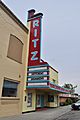
Ritz Theatre
-
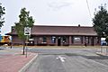
Northern Pacific Railway Depot


See also
 In Spanish: Ritzville (Washington) para niños
