
River Dearne facts for kids
Quick facts for kids River Dearne |
|
|---|---|

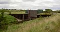
The River Dearne viewed from the bridge behind Darton Post Office.
|
|
| Country | England |
| Physical characteristics | |
| Main source | Birdsedge nr Denby Dale 328 metres (1,076 ft) 53°33′52″N 1°42′37″W / 53.56444°N 1.71028°W |
| River mouth | River Don near Conisbrough 17 metres (56 ft) ACoordinates: Unknown argument format {{#coordinates:}}: invalid latitude |
| Length | 51.9 kilometres (32.2 mi) |
| Basin features | |
| Basin size | 310.8 square kilometres (120.0 sq mi) |
The River Dearne is a river in South Yorkshire, England. It flows for over 30 kilometres (19 mi) from its start in West Yorkshire. The river travels through many towns like Denby Dale, Barnsley, and Mexborough. It eventually joins the River Don near Denaby Main. A major river that flows into the Dearne is the River Dove, which joins it at Darfield.
The Dearne Valley area, especially below Barnsley, is being rebuilt and improved. You can walk along the river on a special long-distance path called the Dearne Way. This path goes from the river's start, called Dearne Head, all the way to where it meets the River Don. Along the way, you can see interesting places like the Yorkshire Sculpture Park and Monk Bretton Priory.
For many years, the river was very polluted because of industries and towns. Fish could not live in it. But thanks to a lot of hard work, the river has become much cleaner since the 1980s. Now, fish populations are returning, and in 2015, salmon were seen in the river for the first time in 150 years! The river has also had special changes made to its path to help prevent flooding.
Contents
River Dearne's Journey
The River Dearne begins its journey high up in the hills, west of Birdsedge. It starts at about 330-metre (1,080 ft) above sea level. After flowing for about 3 kilometres (1.9 mi), it reaches the A635 Barnsley Road bridge in Denby Dale. By this point, it has dropped quite a bit and has been joined by water from several springs. Near Denby Dale, a stream called Munchcliffe Beck adds more water to the river. The river then flows under a large railway bridge with 21 tall arches, built in 1884.
The river continues to flow towards the north-east, following the A636 road closely. It passes through Scissett and west of Clayton West, where it goes under the Kirklees Light Railway. Another stream, Park Gate Dike, joins the river. Further along, the A636 road crosses the river on an old stone bridge from the early 1800s. Nearby, there's an even older hump-backed bridge, probably from the 1700s.
The river then turns east and flows past two lakes that feed the Yorkshire Sculpture Park. Bretton Hall is located to the north. The river turns south at the dam of the lower lake and flows over small waterfalls. It then collects the water flowing out of the lakes.
Next, the river turns south-east and goes under the A637 road and the M1 motorway near Junction 38, reaching Darton. The Cawthorne Dike joins the river from the west. The river then turns east and flows under the railway line that connects Wakefield to Barnsley. The B6428 crosses the river on Barugh Bridge, a stone bridge built in 1850.
As the river gets closer to Barnsley, you can see the remains of the old Barnsley Canal running alongside it. After passing under a few more road bridges, including the A633 Grange Lane, you'll find Priory Mill. This mill is very old, dating back to the 1200s! It used water from the river to power its wheels. Water from the mill's channel also went to Monk Bretton Priory to help clean its kitchens.
Further on, the river passes under two old railway bridges that are now used as footpaths. Sections of the disused Dearne and Dove Canal also run next to the river. The river then turns south to reach Darfield. Below Darfield, the River Dove joins the Dearne from the west.
The river then turns east again, flowing past a series of lakes that are part of the Dearne Ings and Old Moor washlands. On the other side of the river are the Bolton Ings washlands, which are looked after by the Royal Society for the Protection of Birds (RSPB). This area is a great place for birds like spoonbills and avocets. After these washlands, the river flows north of Wath upon Dearne and south of Bolton on Dearne.
A railway line crosses the river near Bolton on Dearne station. Further south, near the village of Adwick upon Dearne, Harlington Road crosses the river on Adwick Bridge. This bridge is a Grade II listed stone bridge built around 1800. A nature reserve called Denaby Ings is separated from the river by a railway bank. The river then curves south to join the River Don near Mexborough Low Lock.
There is a long-distance path called the Dearne Way that follows the entire course of the river. It's about 30 miles (48 km) long and takes about 12 to 16 hours to walk.
Protecting Against Floods
By the 1950s, the river near its mouth was often flooding the land around it. This was because coal mining had caused the ground to sink. To fix this, a new river channel was built in the 1950s. This new path helped the water flow better and reduced flooding. The old river path can still be seen today.
Between 1963 and 1973, a big project called the River Dearne Improvement Scheme was carried out. Instead of just making the river channel wider, which would push the flood problem somewhere else, they created "washlands." These are areas that can be flooded on purpose when river levels get too high. This helps protect towns and villages from flooding.
One of the first washlands, now called the Denaby Ings Nature Reserve, was created in 1963. It has a special gate that can be opened to let river water flow into the washland during floods. More washlands were built at Harlington and North Ings, and parts of the river were straightened.
Further upstream, a flood relief channel was built at Bolton upon Dearne, and more washlands were made. A device called a regulator was installed at Bolton in 1972. This allowed them to control the flow of water with a gate. During the big 2007 United Kingdom floods, all the washlands filled up, which helped a lot. However, the Bolton regulator couldn't be used because it had been damaged. After these floods, experts looked at the regulators again. They might remove them in the future once other changes to the river channel are made. This will help the washlands work even better to manage floods.
River's Health and Water Quality
In the late 1700s, the River Dearne was full of fish. But as industries grew in the valley, especially coal mines, the river started to get polluted. When the Dearne and Dove Canal opened in 1810, it made it easier to transport coal, leading to even more mines. Towns grew quickly, but they didn't have proper ways to treat sewage. So, sewage and waste from the mines went straight into the river.
Mills that processed wool also caused pollution. They used strong chemicals and dyes, and the hot water they used was put back into the river, raising its temperature. By the early 1900s, the river was so polluted between Barnsley and the River Don that no fish could survive. Even in the 1960s, the situation hadn't improved much. Factories were still dumping waste into the river without cleaning it first.
Making Things Better
Thanks to efforts from river boards and local councils, things slowly started to change. By 1974, the water quality was still poor, but small groups of fish began to appear. In the upper part of the river, a few brown trout had survived, but they couldn't move downstream because of dams. Chemicals from moth-proofing in the wool mills were also very harmful to fish. Even after these chemicals were stopped in 1979, they still leaked into the river for another ten years.
By 1987, the water was clean enough to try putting fish back into the upper river. Many young trout were released, and a year later, many were still alive. By 1992, fish were even breeding in the river! Naturally bred brown trout were found for the first time in over 100 years. By 1996, the trout population in the upper Dearne was able to keep itself going.
Further down the river, the water flows slower and forms deeper pools, which are good for other types of fish. By 1974, some fish were found below a weir (a small dam) at the Star Paper Mill in Barnsley. These fish had mostly been washed downstream from nearby lakes. However, serious pollution incidents in the late 1980s killed many of the fish that had been released. Sewage treatment works at Darton and Lundwood were a big part of the problem.
The Darton sewage works had trouble treating dyes from a local carpet factory, making the treated water red and still polluting the river. Big improvements were made to the treatment works, and the carpet factory also started treating its waste. By 1994, fish were appearing again below the Star Paper Mill weir, and more fish were released.
Improvements were also needed at the Lundwood sewage treatment works. As Barnsley's population grew, the works couldn't handle all the sewage. A major upgrade was done between 1997 and 1998 to improve the water quality coming out of the works. Fish populations in the lower river started to get better. To help fish breed, the river channel at Pastures Road, Denaby, was changed. It had been straightened in the 1960s, but now bends were added to create deep pools and shallow gravel areas. These are important for fish like dace and barbel to lay their eggs and for young fish to hide from floods. The water quality has continued to get better, and the lower Dearne is now a popular spot for fishing.
More improvements to the Lundwood sewage treatment works were finished in 2008. To celebrate, a poet named Ian McMillan helped children write a poem about water treatment. In June 2015, amazing news came: salmon had returned to the Dearne for the first time in 150 years! This happened after a fish ladder was opened at Sprotborough weir in 2014, helping salmon swim upstream.
How Water Quality is Measured
The Environment Agency checks the water quality of rivers in England. They give each river a score for its overall health, from "high" to "bad." They look at things like the types of invertebrates (small creatures without backbones), plants, and fish living in the river. They also check for chemicals in the water.
Here's how the River Dearne and its smaller streams were rated in 2015:
| Section | Ecological Status | Chemical Status | Overall Status | Length | Catchment |
|---|---|---|---|---|---|
| Dearne from Source to Bentley Brook | Moderate | Good | Moderate | 8.4 miles (13.5 km) | 11.63 square miles (30.1 km2) |
| Bentley Brook from Source to River Dearne | Good | Good | Good | 5.0 miles (8.0 km) | 5.37 square miles (13.9 km2) |
| Dearne from Bentley Brook to Cawthorne Dyke | Moderate | Good | Moderate | 5.7 miles (9.2 km) | 5.40 square miles (14.0 km2) |
| Cawthorne Dyke from Source to River Dearne | Poor | Good | Poor | 7.9 miles (12.7 km) | 10.43 square miles (27.0 km2) |
| Dearne from Cawthorne Dyke to Lundwood STW | Moderate | Good | Moderate | 6.0 miles (9.7 km) | 8.65 square miles (22.4 km2) |
| Cudworth Dyke from Source to River Dearne | Poor | Good | Poor | 5.1 miles (8.2 km) | 13.27 square miles (34.4 km2) |
| Grimethorpe Dike from Source to River Dearne | Moderate | Good | Moderate | 4.6 miles (7.4 km) | 5.17 square miles (13.4 km2) |
| Dearne from Lundwood to River Dove | Moderate | Good | Moderate | 5.8 miles (9.3 km) | 5.37 square miles (13.9 km2) |
| Dearne from Darfield STW to River Don | Moderate | Good | Moderate | 12.1 miles (19.5 km) | 16.13 square miles (41.8 km2) |
Images for kids
-
The river regulator at Bolton upon Dearne may be removed as part of a flood risk management strategy.

| Point | Coordinates (Links to map resources) |
OS Grid Ref | Notes |
|---|---|---|---|
| Dearne Head | 53°33′53″N 1°42′54″W / 53.5647°N 1.7149°W | SE189076 | source |
| A635 bridge, Denby Dale | 53°34′13″N 1°40′02″W / 53.5702°N 1.6672°W | SE221082 | |
| Junction with Park Gate Dike | 53°35′44″N 1°37′48″W / 53.5955°N 1.6300°W | SE245110 | |
| Bretton Country Park weirs | 53°36′31″N 1°33′46″W / 53.6085°N 1.5627°W | SE290125 | |
| Junction with Cawthorne Dike | 53°34′38″N 1°31′25″W / 53.5771°N 1.5236°W | SE316090 | |
| A633 Grange Lane Bridge | 53°33′05″N 1°26′23″W / 53.5515°N 1.4398°W | SE372062 | Barnsley |
| Junction with River Dove | 53°31′43″N 1°22′07″W / 53.5287°N 1.3686°W | SE419037 | Darfield |
| Junction with River Don | 53°29′39″N 1°14′33″W / 53.4942°N 1.2425°W | SK503999 | mouth |
