
Roads in Puerto Rico facts for kids
   
Highway shields for primary, urban primary, secondary and tertiary sections of PR-1
|
|
 |
|
Quick facts for kids Highway names |
|
|---|---|
| Interstates: | Interstate PRnn (PRI-nn) (unsigned) |
| Commonwealth | Puerto Rico Highway nn (PR-nn) |
| System links | |
| List of Puerto Rico highways | |
The Roads in Puerto Rico are a huge network of pathways that stretch for about 14,400 kilometers (8,900 miles) across the island. These roads help over 3 million people who live in Puerto Rico, plus millions of tourists who visit each year, get around easily.
Puerto Rico's road system is split into four main types: primary, urban primary, secondary, and tertiary. Each type of road has a special shield or sign to show what kind it is. The main roads are looked after by the Puerto Rico Department of Transportation and Public Works (DTOP).
Puerto Rico also has "Interstate Highways," which are not signed like those in the mainland U.S. These roads get money from the U.S. federal government because people in Puerto Rico pay federal taxes. This funding helps keep the roads in good shape.
Some roads, called Forest Highways, are found inside the El Yunque National Rain Forest. These are maintained by the United States Forest Service.
Finally, "municipal roads" are local streets within Puerto Rico's 78 municipalities. These roads have street names and signs, and the local governments are in charge of keeping them in good condition.
Contents
How Did Puerto Rico's Roads Begin?


Long ago, in the 1500s, there was already a rough path called the Camino de Puerto Rico. It connected different parts of the island, like San Germán and Caparra.
The first major roads in Puerto Rico were built by the Spanish government before Puerto Rico became part of the United States. In 1886, a special law called the Ley de carreteras para la Isla de Puerto Rico (Law of the highways of the island of Puerto Rico) was passed to describe how roads should be built.
These early roads were paved with macadam, which is a mix of crushed rock and cement. They were maintained by special workers called Peones Camineros, or "walking workers." These workers and their families lived in small buildings called casillas along the highways. Their job was to walk about 3 kilometers (1.9 miles) in each direction from their home every day to check the road for any damage. This system worked very well!
After the Treaty of Paris in 1898, when the United States took over Puerto Rico, they were very impressed with the roads. They even called Puerto Rico's Carretera Central "the finest road in the Western Hemisphere."

In 1905, the United States stopped this system, and the roads quickly got worse. When the "walking workers" system was brought back nine years later, the roads improved again. However, the system finally ended for good in 1950.
By 1940, the United States focused on making roads and bridges strong enough to carry heavy military equipment, which was important for national defense.
Who Takes Care of the Roads?
_01.jpg)
The roads that are part of the Puerto Rico Highway System are maintained by the Puerto Rico Department of Transportation and Public Works (DTOP). This is a central government agency. Even if a road is inside a city or town, if it's part of the Highway System, DTOP is responsible for it. DTOP has offices all over the island to help with road maintenance.
Sometimes, there are disagreements about who should fix a road, especially after big storms like Hurricane Maria. Local city governments are only responsible for the streets within their own towns. However, sometimes the central government and local governments work together to maintain a state highway that runs through a municipality.
Understanding the National Highway System
The National Highway System of Puerto Rico includes about 1,151 kilometers (715 miles) of roads. These roads are divided into four types: primary, urban primary, secondary, and tertiary.

All major expressways in Puerto Rico are either primary or urban primary roads. Some of these roads are freeways, which means you can get on and off them only at specific points. If a freeway charges a fee to use it, it's called an autopista. Most toll booths use the AutoExpreso system to collect these fees.
In 2009, primary roads made up about 14% of the total system, secondary roads were about 30%, and tertiary roads were about 56%.
A road keeps its number even if it changes from one network type to another. For example, PR-1 connects Ponce and San Juan. Inside Ponce, it might be an urban primary road. In a rural area like Capitanejo, it might become a secondary road. Then, when it enters another town like Santa Isabel, it might become an urban primary road again. This means the same road number can have different shield types depending on where it is.
Primary Network Highways
Primary roads are numbered from 1 to 99. Their signs have a white background with a blue shield and white letters. These roads help people and goods move between the main regions of the island.
-
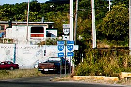
PR-54 West and East junction with PR-744 in Guayama

Urban Primary Network Highways
Urban primary highways help the primary road network inside Puerto Rico's eight main city areas. These areas include San Juan, Ponce, and Mayagüez. Some highways might have an "R" (for Ramal, meaning branch) added to their number. This happens when the main highway goes around a town, and a branch goes through the town center. The urban primary sign has black letters on a white shield with a black background.
-
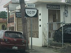
PR-1107P in Aguadilla barrio-pueblo

Secondary Network Highways
Secondary highways connect towns and cities to the primary roads. Their signs have yellow letters on a blue shield with a yellow border.
Because Puerto Rico has many mountains, some secondary highways can be tricky to drive on. For example, Puerto Rico Highway 172 connects Caguas and Cidra. It has steep hills and sometimes unsafe barriers, which can be dangerous.
Secondary roads are numbered from 100 to 299. They generally start in the southwest part of the island with PR-100 and increase as you go northeast. The highest secondary highway number is 252 (PR-252), which is on the island of Culebra.
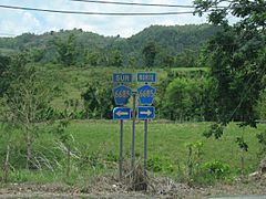
-
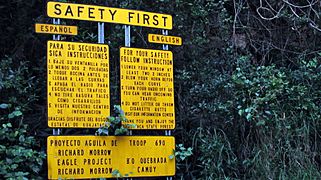
"For your safety" tips for driving in Puerto Rico sign
-
PR-145 in Torrecillas, Morovis


Tertiary Network Highways
Tertiary highways connect a town's main area to smaller communities nearby. The sign for a tertiary highway is a white circle with black letters on a black background. Roads that start and end within the same municipality are usually tertiary roads and are numbered from PR-300 to PR-9999. You might still see older road signs shaped like the island of Puerto Rico on some roads.
Three-Digit Tertiary Roads

Tertiary highways, also known as local highways, follow a general numbering pattern. In the area west of San Juan, northern roads have even numbers, and southern roads have odd numbers. East of San Juan, roads in the 900-999 range cover both northern and southern areas.
For example, in the mountainous town of Ciales, you can find highways in both the 600-699 range and the 500-599 range. On the island of Vieques, some highways are in the 900-999 range, but it also shares roads in the 200-299 category with Culebra.


-
PR-438, a steep roadway, seen from Calabazas barrio, San Sebastián
-
PR-435 and PR-124 highway junction in Espino, Lares


Four-Digit Tertiary Roads
Some roads have four digits, like PR-5506. These are usually branches or loops off a main tertiary road. For example, PR-5506 is a branch of PR-506. They are often dead-end roads, especially in the mountains. The first digit of the four-digit number usually repeats the first digit of the main road. So, a branch of PR-301 might be signed as PR-3301.
-
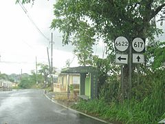
PR-6622 and PR-617 signs in Morovis
-
Puerto Rico Highway 6685 in Manatí
-
Kilometer 1.0 on a road in Naguabo


Puerto Rico's "Interstate" Highways


From 2016 to 2020, Puerto Rico received $158 million each year for its Highway Program from the federal government. Even though Puerto Rico is an island and doesn't connect to other states by land, three of its main roads (PRI-1, PRI-2, and PRI-3) are called "Interstate Highways" for funding reasons. They get a lot of their money from the Interstate Highway System. People in Puerto Rico pay federal taxes, including fuel and tire taxes, which contribute to this funding. These "Interstate" roads in Puerto Rico are not signed like the ones in the mainland U.S.
PRI-1 is about 114.4 kilometers (71.08 miles) long, PRI-2 is about 222.3 kilometers (138.13 miles) long, and PRI-3 is about 65.2 kilometers (40.56 miles) long. They don't follow the usual even and odd numbering rules used in the mainland United States.
U.S. Forest Highways
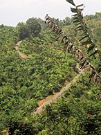
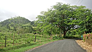
The El Yunque National Forest has special road signs. These signs are brown, shaped like an upside-down trapezoid, and say Bosque Nacional (National Forest). This is the same type of sign used for forest highways in the United States.
-
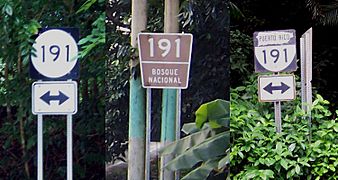
Markers at the El Yunque National Rain Forest

Municipal Roadways

In Puerto Rico, a municipal road is a public road that does not have a Puerto Rico National Highway system sign. Unlike state roads, which have numbers, municipal roads have names, like Calle Pedro Albizu Campos.
Sometimes, the term "municipal road" can be confusing. When people talk about roads maintained by the state government, "municipal roads" might refer to tertiary state roads. However, if they are talking about roads maintained by the local city government, it means the local streets within that city.
The purpose of a road can also help you understand if it's a "municipal road." In its simplest meaning, municipal roads are local streets within a city that connect different neighborhoods. But in the bigger picture of the state highway system, "municipal roads" can also refer to tertiary roads that connect smaller communities to a town's main area.
Municipal roads are maintained by the local city government where they are located. Tertiary roads, however, are maintained by the state government. As mentioned before, sometimes the state and local governments agree to work together to maintain a state tertiary road, but this doesn't change its official status as a state road.
See also
 In Spanish: Carreteras de Puerto Rico para niños
- List of toll roads in the United States § Puerto Rico
- List of highways in Ponce, Puerto Rico
- 1953 Puerto Rico highway renumbering
