
Vieques, Puerto Rico facts for kids
Quick facts for kids
Vieques
Municipio Autónomo de Vieques
Isla de Vieques
|
|||
|---|---|---|---|
|
Island-Municipality
|
|||

Mosquito Bioluminescent Bay in Vieques
|
|||
|
|||
| Nicknames:
"Isla Nena", "Isabel Segunda"
|
|||

Map of Puerto Rico highlighting Vieques Municipality
|
|||
| Country | |||
| Commonwealth | |||
| Indigenous settlement | 3000 – 2000 BCE | ||
| Spanish settlement | 1811 | ||
| Isabel II founded | 1843 – 1852 | ||
| Municipality founded | July 1, 1875 | ||
| Founded by | Teófilo José Jaime María Le Guillou | ||
| Barrios |
8 barrios
|
||
| Area | |||
| • Total | 135 km2 (52 sq mi) | ||
| Population
(2020)
|
|||
| • Total | 8,249 | ||
| • Rank | 76th in Puerto Rico | ||
| • Density | 61.10/km2 (158.3/sq mi) | ||
| Demonym(s) | Viequense | ||
| Racial groups | |||
| • White | 48.7% | ||
| • Black | 38.1% | ||
| • American Indian/AN | 0.4% | ||
| • Asian - Native Hawaiian/Pi |
0.6% 0.8% |
||
| • Other Two or more races |
8.8% 3.4% |
||
| Time zone | UTC−4 (AST) | ||
| ZIP Code |
00765
|
||
| Area code(s) | 787/939 | ||
| Major routes | |||


Vieques (pronounced "vee-AY-kes") is an island, town, and municipality of Puerto Rico. It is part of the Spanish Virgin Islands along with Culebra. Vieques is located about 8 miles (13 km) east of the main island of Puerto Rico. It is about 20 miles (32 km) long and 4.5 miles (7.2 km) wide.
The most populated area is Isabel Segunda, also known as "Isabel the Second." This town is the administrative center and is on the northern side of the island. In 2020, about 8,249 people lived in Vieques.
The name "Vieques" comes from a Taíno word meaning "small island" or "small land." The island is also called Isla Nena, which means "girl island" or "little girl island." This nickname was given by the Puerto Rican poet Luís Lloréns Torres. During the time when the British were colonizing the Americas, Vieques was known as Crab Island.
Vieques is well-known because of protests against the United States Navy's use of the island. The Navy used parts of the island for training exercises and testing. These protests led to the Navy leaving Vieques in 2003. Today, the land that used to belong to the Navy is a national wildlife refuge. Some parts are open to visitors, but other areas are closed because they need to be cleaned up from old military items.
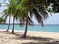
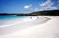
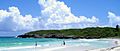
Some of the most beautiful beaches on Vieques are on the eastern side. These include Red Beach, Blue Beach, Caracas Beach, Pata Prieta Beach, La Chiva Beach, and Plata Beach. On the far western tip is Punta Arenas, also called 'Green Beach'. These beaches are famous in the Caribbean for their clear blue waters and white sands.
Contents
Island History: A Look Back
Early Inhabitants of Vieques
Archaeologists believe that the first people arrived in Vieques between 3000 BCE and 2000 BCE. These early groups came mostly from South America. They had a Stone Age culture and likely lived by fishing and gathering food.
At the Puerto Ferro site, scientists found a human skeleton in a large fire pit. Shells found there suggest the burial happened around 1900 BCE. This skeleton, known as El Hombre de Puerto Ferro, was buried near large rocks on the south-central coast.
Over many centuries, more Native American groups settled on the island. The Arawak-speaking Saladoid people arrived around 200 BC. They were known for their pottery and stone carvings. These tribes later joined with groups from Hispaniola and Cuba to form the Taíno culture. The Taíno culture thrived in the region until Europeans arrived in the late 1400s.
Spanish Rule and New Settlers
Christopher Columbus may have discovered Vieques in 1493 when he landed in Puerto Rico. Spain soon claimed the island. In the early 1500s, Vieques became a place where the Taíno people rebelled against the European invaders. The Spanish sent soldiers to stop the resistance. Many Taíno people were killed, imprisoned, or enslaved.
Spain did not settle Vieques permanently at that time. For the next 300 years, it was a lawless place used by pirates and outlaws. Other European countries, like France, England, and Denmark, tried to colonize the island. But the Spanish always fought them off.
In the early 1800s, Spain decided to settle Vieques for good. In 1811, Juan Rosselló was sent to begin the process of adding Vieques to Puerto Rico. In 1832, a Frenchman named Teófilo José Jaime María Le Guillou became Governor of Vieques. He helped set up large farms, which brought big changes to the island. Le Guillou is often called the founder of Vieques. Vieques officially became part of Puerto Rico in 1854.
In the mid-1800s, thousands of enslaved people from Africa were brought to Vieques. They came from mainland Puerto Rico and other Caribbean islands like St. Thomas and Saint Croix. They were forced to work on sugarcane plantations. Slavery was ended in Puerto Rico in 1873.
Vieques Under United States Control

After the Spanish–American War in 1898, Spain gave Puerto Rico to the United States. Vieques became a U.S. territory. In 1899, the first U.S. census showed that Vieques had 6,642 people.
In the 1920s and 1930s, the sugar industry in Vieques faced problems. Prices dropped, and workers went on strike. Many people had to leave Vieques to find work in mainland Puerto Rico or Saint Croix.
In 1941, during World War II, the United States Navy bought or took control of almost 80% of Vieques. This land was used to expand the Roosevelt Roads Naval Station nearby. The Navy's goal was to have a strategic base in the Atlantic Ocean.
The Navy bought land from large farms and sugar plantations. This ended the sugar industry on the island. Many farm workers, who did not officially own their land, were forced to leave. The Navy decided to use the island for training exercises without asking the local people.
For over 60 years, the U.S. military used Vieques for live training. This meant they used real weapons. According to Navy documents, training happened about 180 days a year. The military used certain types of munitions, and this caused concerns about the environment and the health of the people living there.

After World War II, the U.S. Navy continued to use Vieques for military exercises. This caused many protests from the local community. People were upset that their land was taken and worried about the environmental effects of the training. The island's poor economy also added to their unhappiness.

Protests became very strong in 1999. A local man named David Sanes, who worked for the Navy as a security guard, was killed by a bomb during a training exercise. This event led to a big wave of civil disobedience. People from Vieques went out in their fishing boats to stop the Navy's exercises. The U.S. Coast Guard had to control access to the island.
On April 27, 2001, the Navy started its operations again, and protests continued. More than 600 protesters were arrested. The issue of Vieques gained a lot of attention. Protesters from Vieques were joined by famous people and groups from the U.S. mainland and other countries. These included political leaders like Robert F. Kennedy Jr. and Al Sharpton, singers like Ricky Martin, and actors like Jimmy Smits.
Because of this pressure, the Navy left Vieques in May 2003. Much of the island became a National Wildlife Refuge, managed by the United States Fish and Wildlife Service. The island was also put on a list of sites that need long-term cleanup. The nearby Roosevelt Roads Naval Station closed in 2004.
A report in 2021 said that millions of old military items had been removed from the training site. Cleanup efforts are expected to continue for many years.
Hurricane Maria and Rebuilding Efforts

On September 20, 2017, Hurricane Maria hit Puerto Rico, causing a lot of damage. The storm greatly affected Vieques's economy, which relies on tourism. The largest hotel on the island, The W, has not reopened since the storm. However, many smaller hotels and guesthouses are now open again.
As of December 2019, the Susana Centeno Hospital in Vieques was still closed due to hurricane damage. People needing medical care, like expectant mothers or those needing dialysis, had to travel to the main island of Puerto Rico.
In January 2020, the Federal Emergency Management Agency (FEMA) approved $39.5 million to rebuild the hospital. Construction was expected to begin in 2022 but was delayed until 2023. As of November 2024, the hospital construction was still not finished.
Exploring Vieques: Geography and Nature

Vieques is about 21 miles (34 km) long from east to west and 3 to 4 miles (4.8 to 6.4 km) wide from north to south. It covers about 52 square miles (135 km2) and is about 10 miles (16 km) east of Puerto Rico. The Atlantic Ocean is to the north, and the Caribbean is to the south. Culebra island is about 10 miles (16 km) north of Vieques. The United States Virgin Islands are to the east. Vieques and Culebra, along with small islets, form the Spanish Virgin Islands.
The land that used to be controlled by the U.S. Navy is now wildlife reserves. These areas are at the eastern and western ends of Vieques. The very eastern tip was a live weapons testing site. These areas are not populated. The central part of the island is where most people live. It includes the towns of Isabel Segunda on the north coast and Esperanza on the south.
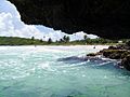
Vieques has rolling hills, with a ridge running east to west. The highest point is Monte Pirata, which is 987 feet (301 m) high. The island's geology includes volcanic rock, sedimentary rocks like limestone, and alluvial deposits of gravel, sand, and clay. There are no permanent rivers or streams. Much of the old farmland is now covered by brush and subtropical dry forest. Along the coast, you can find sandy beaches, lagoons, mangrove swamps, salt flats, and coral reefs.
Several small islands and rocks near Vieques are also part of the municipality:
- Roca Cucaracha
- Isla Yallis
- Roca Alcatraz
- Cayo Conejo
- Cayo Jalovita
- Cayo Jalova
- Isla Chiva
- Cayo Chiva
- Cayo de Tierra
- Cayo de Afuera (Cayo Real)
The Amazing Bioluminescent Bay
.jpg)
The Vieques Bioluminescent Bay, also called Puerto Mosquito or Mosquito Bay, is known as the "Brightest bioluminescent bay" in the world. It was recognized by Guinness World Records in 2006. It is also a national natural landmark, one of five in Puerto Rico. The bay glows because of tiny living things called dinoflagellates, specifically Pyrodinium bahamense. These organisms light up with a neon blue glow when the water is moved.
Several things make this bioluminescence possible. Red mangrove trees grow around the bay. There is no modern development around the bay, keeping it natural. The water is warm and deep enough. A small channel connects the bay to the ocean, but it keeps the dinoflagellates inside. This channel was actually made by people. Spanish sailors tried to block the bay from the ocean by dropping large rocks. They thought the glowing water was evil. But their efforts only made the bay more isolated and increased the glow!
You can go Kayaking in the bay. Local companies offer tours for visitors.
Vieques Climate: Warm and Sunny
Vieques has a warm, tropical climate that is relatively dry. Temperatures do not change much throughout the year. Average high temperatures range from about 85°F (29°C) in January to 90°F (32°C) in September. Average low temperatures are about 18°F (10°C) cooler.
The island gets about 40 to 45 inches (1016 to 1143 mm) of rain each year. September is usually the wettest month. The western part of the island gets more rain than the eastern part. Winds usually blow from the east.
Vieques can be affected by tropical storms and hurricanes from June to November. In 1989, Hurricane Hugo caused a lot of damage. In 2017, Hurricane Maria also caused major damage to the island.
| Climate data for Vieques Island, Puerto Rico (1955–1976 normals, extremes 1955–1976) | |||||||||||||
|---|---|---|---|---|---|---|---|---|---|---|---|---|---|
| Month | Jan | Feb | Mar | Apr | May | Jun | Jul | Aug | Sep | Oct | Nov | Dec | Year |
| Record high °F (°C) | 90 (32) |
90 (32) |
92 (33) |
95 (35) |
93 (34) |
94 (34) |
93 (34) |
94 (34) |
95 (35) |
94 (34) |
94 (34) |
90 (32) |
95 (35) |
| Mean daily maximum °F (°C) | 84.7 (29.3) |
85.2 (29.6) |
86.4 (30.2) |
87.5 (30.8) |
88.4 (31.3) |
89.4 (31.9) |
89.6 (32.0) |
89.7 (32.1) |
89.9 (32.2) |
89.3 (31.8) |
87.9 (31.1) |
85.7 (29.8) |
87.8 (31.0) |
| Mean daily minimum °F (°C) | 66.9 (19.4) |
66.6 (19.2) |
67.0 (19.4) |
68.1 (20.1) |
70.4 (21.3) |
71.7 (22.1) |
71.6 (22.0) |
71.7 (22.1) |
71.5 (21.9) |
70.9 (21.6) |
69.5 (20.8) |
67.8 (19.9) |
69.5 (20.8) |
| Record low °F (°C) | 55 (13) |
52 (11) |
54 (12) |
56 (13) |
59 (15) |
59 (15) |
60 (16) |
63 (17) |
63 (17) |
60 (16) |
61 (16) |
57 (14) |
52 (11) |
| Average precipitation inches (mm) | 2.74 (70) |
1.29 (33) |
1.31 (33) |
2.30 (58) |
4.40 (112) |
3.22 (82) |
3.16 (80) |
5.02 (128) |
5.25 (133) |
5.00 (127) |
4.98 (126) |
3.39 (86) |
42.06 (1,068) |
| Source: Western Regional Climate Center | |||||||||||||
People and Culture of Vieques
Population and Demographics
| Historical population | |||
|---|---|---|---|
| Census | Pop. | %± | |
| 1900 | 5,938 | — | |
| 1910 | 10,425 | 75.6% | |
| 1920 | 11,651 | 11.8% | |
| 1930 | 10,582 | −9.2% | |
| 1940 | 10,362 | −2.1% | |
| 1950 | 9,228 | −10.9% | |
| 1960 | 7,210 | −21.9% | |
| 1970 | 7,767 | 7.7% | |
| 1980 | 7,662 | −1.4% | |
| 1990 | 8,602 | 12.3% | |
| 2000 | 9,106 | 5.9% | |
| 2010 | 9,301 | 2.1% | |
| 2020 | 8,249 | −11.3% | |
| U.S. Decennial Census 1899 (shown as 1900) 1910–1930 1930–1950 1960–2000 2010 2020 |
|||
According to the 2020 Census, Vieques has a population of 8,249 people. This makes it one of the least populated municipalities in Puerto Rico. Most people in Vieques are of Hispanic or Latino background. People from Vieques are called Viequenses.
Both Spanish and English are official languages in Vieques. Spanish is the main language spoken by most people.
Economy: From Sugar to Tourism
The sugar industry used to be the main source of income for Vieques. However, it declined in the early 1900s and ended in the 1940s when the U.S. Navy took over much of the land. After the Navy arrived, some jobs became available through naval work. Crops grown on the island include avocados, bananas, coconuts, and sweet potatoes.
When the U.S. Navy left in 2003, the island's economy faced challenges. Efforts began to rebuild farming and develop Vieques as a tourist spot. Today, the Navy's cleanup work is the largest employer on the island. This work helps the local economy through salaries and services.
Tourism: Discovering Vieques's Beauty

For 60 years, most of Vieques was closed off by the U.S. Navy. This meant the island remained mostly undeveloped for tourism. Now, this lack of development is a key attraction. Vieques is promoted as an ecotourism destination. It is seen as a quiet, unspoiled island with beautiful, empty beaches. It is quickly becoming a popular place to visit.
Since the Navy left, the island has been peaceful. However, some local residents are concerned about new construction and too much development.
The lands previously owned by the Navy are now wildlife reserves. They are managed by the U.S. National Fish and Wildlife Service and Puerto Rican authorities. Some areas that were used for training need cleaning up. But many other areas are open to the public, including beautiful beaches that were once closed.
Snorkeling is excellent, especially at Blue Beach (Bahía de la Chiva). Besides old archaeological sites and quiet beaches, Vieques has two special bioluminescent bays, including Mosquito Bay. Vieques is also known for its paso fino horses, which roam freely on parts of the island.
In 2011, TripAdvisor listed Vieques among the Top 25 Beaches in the World. They noted that Vieques has over 40 beaches and no traffic lights.
Landmarks and Places to Visit

- Fortín Conde de Mirasol (Count Mirasol Fort): A fort built by the Spanish in the mid-1800s, now a museum.
- Playa Esperanza (Esperanza Beach)
- The tomb of Le Guillou: The town founder, located in Isabel Segunda.
- La Casa Alcaldía (City Hall)
- Faro Punta Mulas: A lighthouse built in 1896.
- Faro de Puerto Ferro
- Sun Bay Beach
- The Bioluminescent Bay
- The 300-year-old ceiba tree
- Rompeolas (Mosquito Pier): Renamed Puerto de la Libertad David Sanes Rodríguez in 2003.
- Puerto Ferro Archaeological Site
- Black Sand Beach (Playa Negra)
- Hacienda Playa Grande (Old Sugarcane Plantation Building)
- Underground U.S. Navy Bunkers
- Wreckage of the World War II Navy Destroyer USS Killen (DD-593)
Culture and Celebrations
Festivals and Events

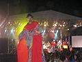
Vieques celebrates its patron saint festival in July. The Fiestas Patronales de Nuestra Señora del Carmen is a religious and cultural event. It usually includes parades, games, local crafts, rides, regional food, and live music.
Other festivals and events in Vieques include:
- Three Kings Festival – January 6
- Festival Cultural Viequense (Vieques Cultural Festival) – June
- Festival de la Arepa – August/September
Symbols of Vieques
The municipio (municipality) of Vieques has an official flag and coat of arms.
Flag of Vieques
The Vieques flag was approved in 1975. It shows the municipal coat of arms and has the same meaning. It has seven horizontal stripes of equal width: four white and three blue, alternating. In the middle, there is a green diamond shape with a simplified yellow castle design.
Coat of Arms
The coat of arms has silver and blue waves, which stand for the sea around Vieques. In the middle, a green diamond shape shows a historic Vieques fort, represented by a traditional Spanish castle.
Getting Around Vieques
Transportation Options
Vieques is served by Antonio Rivera Rodríguez Airport. This airport handles only small propeller planes. Flights to Vieques come from San Juan's Luis Muñoz Marín International Airport, Isla Grande Airport (20-30 minute flights), and from Ceiba Airport (5-minute flights). You can also fly between Vieques and Saint Croix, Tortola, Virgin Gorda, and Saint Thomas.
A ferry also runs from Ceiba several times a day. The ferry service is managed by the Autoridad de Transporte Marítimo (ATM) in Puerto Rico. In 2019, Governor Wanda Vázquez Garced said she would work to improve the ferry service.
Vieques has 13 bridges, none of which are particularly famous.
Famous People from Vieques
- Jaime Rexach Benitez: An educator, politician, and humanist.
- Susana Centeno: A nurse and public servant.
- Nelson Dieppa: A professional boxer.
- Juan Francisco Luis: Governor of the U.S. Virgin Islands (1978–1987).
- Germán Rieckehoff Sampayo: Former president of the Puerto Rican Olympic committee.
- Carlos Vélez Rieckehoff: A local nationalist leader and political activist.
- David Sanes Rodríguez: A civilian killed by the U.S. Navy during a training exercise. His death led to protests that resulted in the Navy leaving the island.
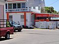
Images for kids
-
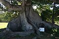
300-year-old Ceiba Tree in Isabel II
-
Sun Bay Beach
-
A view of Tobarrios Navío Beach from a nearby sea cave
-
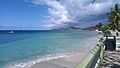
A view from the Malecón (promenade) in Esperanza tobarrios of Cayo de Afuera
-
Playa Caracas (Red Beach)
-
Navío Beach
-
Festival Viequense (2007)
-
Esperanza Beach
-
Isabella II, Vieques
-
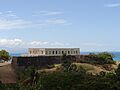
Fort Count of Mirasol
-
Playa Grande Sugar Plantation
-
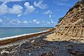
Playa Negra, a black sand beach
-
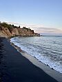
Playa Negra and cliffs
-
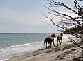
Wild horses on Playa Negra
-
Esperanza
-
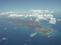
Aerial view from East


See also
 In Spanish: Isla Vieques para niños
