
Rock Mountain (Washington state) facts for kids
Quick facts for kids Rock Mountain |
|
|---|---|

Rock Mountain, northwest aspect
|
|
| Highest point | |
| Elevation | 6,840 ft (2,080 m) |
| Prominence | 640 ft (200 m) |
| Isolation | 1.37 mi (2.20 km) |
| Parent peak | Mount Howard (7,063 ft)> |
| Geography | |

Rock Mountain
Location in Washington (state)

Rock Mountain
Location in the United States
|
|
| Location | Chelan County, Washington, U.S. |
| Parent range | North Cascades Cascade Range |
| Topo map | USGS Mount Howard |
| Climbing | |
| Easiest route | Hiking trail |
Rock Mountain is a tall mountain in Washington state, standing 6,840 feet (2,085 meters) high. It's found in Chelan County, about 6.3 miles (10.1 kilometers) northeast of Stevens Pass. You can find it north of U.S. Highway 2, between Stevens Pass and Lake Wenatchee. This area is part of the Okanogan-Wenatchee National Forest.
Rock Mountain is the second-highest peak on Nason Ridge. It's just a bit shorter than Mount Howard, which is 1.37 miles (2.2 kilometers) away to the northeast. A person named Albert Hale Sylvester gave the mountain its name. Rain and snow melting from the mountain flow into streams that eventually join the Wenatchee River.
Contents
How Rock Mountain Was Formed
The North Cascades mountains, where Rock Mountain is located, have very rugged shapes. They feature sharp peaks, long ridges, and deep valleys carved by glaciers. Many years ago, huge geological events created these varied landscapes. These events also caused big changes in elevation, which led to different climates across the Cascade Range.
Millions of Years of Change
The Cascade Mountains began forming millions of years ago, during a time called the late Eocene Epoch. This happened because the North American Plate was slowly moving over the Pacific Plate. This movement caused many volcanic eruptions. For example, Glacier Peak, a large volcano, started forming about 22.5 miles (36.2 kilometers) north of Rock Mountain.
Also, small pieces of the Earth's outer layers, called terranes, crashed into North America. These collisions helped create the North Cascades about 50 million years ago.
The Power of Glaciers
During the Pleistocene period, which started over two million years ago, glaciers grew and shrank many times. These giant ice sheets moved across the land, carving and shaping the mountains and valleys. Glaciers were biggest about 18,000 years ago. Most valleys were free of ice by 12,000 years ago.
The lifting of the land (called uplift) and cracks in the Earth's crust (called faulting) worked with the glaciers. Together, these forces created the tall peaks and deep valleys you see in the North Cascades today.
Weather and Climate Around Rock Mountain
Rock Mountain is located east of the main Cascade mountain crest. This means the area is a bit drier than places to the west. In summer, it can get warm, and sometimes there are thunderstorms.
How Mountains Affect Weather
Most weather systems start over the Pacific Ocean. They then travel east toward the Cascade Mountains. As these weather fronts approach the mountains, they are forced to rise. This upward movement causes them to drop their moisture as rain or snow onto the Cascades. This process is called Orographic lift.
Because of this, the western slopes of the Cascades get a lot of rain and snow, especially in winter. During winter, the weather is often cloudy. However, in summer, high-pressure systems over the Pacific Ocean become stronger. This often leads to clear skies with little or no cloud cover.
Images for kids
-
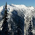
Southeast view of Nason Ridge
-
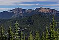
Mount Howard (left) and Rock Mountain (right) seen from Mount McCausland
-
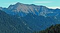
West view of Rock Mountain


