Rockwell Formation facts for kids
Quick facts for kids Rockwell FormationStratigraphic range: Late Devonian to Early Mississippian |
|
|---|---|

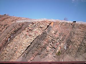
Rockwell Formation at Sideling Hill, I-68 roadcut
|
|
| Type | Sedimentary |
| Sub-units | Finzel Tongue, Patton Shale, Riddlesburg Shale |
| Underlies | Pocono Formation and Purselane Sandstone |
| Overlies | Hampshire Formation |
| Thickness | 500 to 540 feet in WV, 540 to 550 feet at Sideling Hill |
| Lithology | |
| Primary | Sandstone, shale, conglomerate |
| Location | |
| Region | Appalachian Mountains |
| Extent | West Virginia, Maryland, Pennsylvania |
| Type section | |
| Named for | Rockwell Run, West Virginia |
| Named by | Stose and Swartz, 1912 |
The Rockwell Formation is a special type of rock layer found in the ground. It formed a very long time ago, during the late Devonian and early Mississippian periods. You can find this rock unit in parts of the United States, specifically in West Virginia, Maryland, and Pennsylvania.
What is the Rockwell Formation?
The Rockwell Formation is a layer of rock that geologists study. It is made up of different kinds of rocks. These include soft sandstone (a rock made from sand grains), hard conglomerate (a rock with rounded pebbles stuck together), and buff-colored shale (a rock made from mud and clay).
Scientists first described this rock layer at a place called Rockwell Run in West Virginia. This happened in 1912, thanks to scientists named Stose and Swartz. Later, other scientists like H. E. Vokes (in 1957) and C. R. Wood (in 1980) studied and described it in Maryland and Pennsylvania.
How Rockwell Formation fits in the Earth's layers
In geology, a "Formation" is a main rock unit that scientists can map. The Rockwell Formation is one such unit. It has smaller parts inside it, which scientists call "members." These include the Patton Shale, the Riddlesburg Shale, and the Finzel Tongue.
Sometimes, scientists change how they classify rock layers. In West Virginia, the Rockwell Formation is sometimes considered a "member" of a larger rock unit called the Price Formation. This means it's a smaller part of a bigger group of rocks.
The Rockwell Formation is also similar to other rock layers nearby, like the Huntley Mountain Formation and the Spechty Kopf Formation. All these rock layers are found underneath the well-known Pocono Formation.
Scientists have studied the Rockwell Formation in different areas. For example, in Berkeley County, West Virginia, the Rockwell layer is about 200 meters (about 656 feet) thick. Near the bottom of this layer, there's a special type of rock called a diamictite. A diamictite is a rock that contains a mix of different sized pieces, from very fine grains to large boulders, all mixed together without any clear layers.
 | Percy Lavon Julian |
 | Katherine Johnson |
 | George Washington Carver |
 | Annie Easley |


