
Rosebud River facts for kids
Quick facts for kids Rosebud River |
|
|---|---|

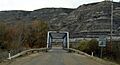
Highway 10X bridge over Rosebud River (one of 11)
|
|
| Country | Canada |
| Province | Alberta |
| Physical characteristics | |
| Main source | 1,095 meters (3,593 ft) 51°35′36″N 114°11′07″W / 51.59329°N 114.18531°W |
| River mouth | Red Deer River 675 meters (2,215 ft) 51°25′15″N 112°37′47″W / 51.42072°N 112.62979°W |
The Rosebud River is a cool river in Alberta, Canada. It's a main branch, also called a tributary, of the bigger Red Deer River.
This river flows through lots of different places. You'll see it winding through farmland and areas where ranchers raise animals. Towards its end, it even goes through amazing badlands – these are dry, rocky areas with cool shapes. The Rosebud River is super important because it helps provide water for irrigation (watering crops) using special canals and dams built along its path.
Did you know the name "Rosebud River" comes from the Blackfoot language? Their word Akokiniskway means "the river of many roses." How pretty is that?
Contents
Where Does the Rosebud River Start and End?
The Rosebud River begins its journey in central Alberta. It starts high up, about 1,095 meters (3,593 feet) above sea level, southwest of a town called Didsbury.
The River's Journey Through Alberta
From its start, the river flows north for a bit. It passes a dam and goes under Highway 582 and the Canadian Pacific Railway tracks. It then gets more water from Copeley Lake before turning south. It flows right through Didsbury, where it crosses Highway 582 and Highway 2A again.
The Rosebud River then takes a general southeast direction. It goes under Highway 2 and Highway 581. It keeps heading southeast, passing north of Irricana and south of Beiseker, where it's crossed by Highway 72 and Highway 9.
As it continues east, the river enters southern Alberta. Here, it's crossed by Highway 21 and Highway 840 near the small community of Rosebud. After this, the river turns northeast. The Canadian National Railway tracks follow its path, and it's crossed by Highway 841.
Exploring the Badlands Canyon
When the Rosebud River reaches the community of Wayne, something really cool happens! Highway 10X starts to follow the river through a deep badlands canyon. This canyon can be as deep as 150 meters (492 feet)! It's so winding that there are eleven bridges that cross the river back and forth through this amazing canyon.
Finally, the Rosebud River finishes its long journey. It flows into the Red Deer River near Rosedale. At this point, the river is about 675 meters (2,215 feet) above sea level.
Images for kids
-
Highway 10X bridge over Rosebud River (one of 11)
