Roslyn Harbor, New York facts for kids
Quick facts for kids
Roslyn Harbor, New York
|
||
|---|---|---|
| Incorporated Village of Roslyn Harbor | ||

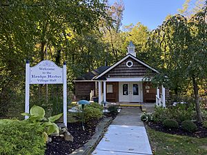
Roslyn Harbor Village Hall and Courthouse on October 17, 2020.
|
||
|
||
| Nickname(s):
"Switzerland of Long Island"
|
||

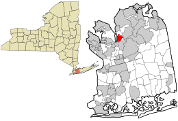
Location in Nassau County and the state of New York
|
||
| Country | ||
| State | ||
| County | Nassau | |
| Town | North Hempstead Oyster Bay |
|
| Incorporated | October 17, 1931 | |
| Named for | Its proximity to Roslyn and Hempstead Harbor | |
| Area | ||
| • Total | 1.19 sq mi (3.09 km2) | |
| • Land | 1.19 sq mi (3.08 km2) | |
| • Water | 0.00 sq mi (0.00 km2) | |
| Elevation | 108 ft (33 m) | |
| Population
(2020)
|
||
| • Total | 1,067 | |
| • Density | 895.89/sq mi (345.97/km2) | |
| Demonym(s) | Roslynian Roslynite |
|
| Time zone | UTC−5 (Eastern (EST)) | |
| • Summer (DST) | UTC−4 (EDT) | |
| ZIP codes |
11545, 11548, 11576
|
|
| Area codes | 516, 363 | |
| FIPS code | 36-63803 | |
| GNIS feature ID | 0962933 | |
Roslyn Harbor is a small village in Nassau County. It is located on the North Shore of Long Island, in New York. It is considered part of the larger Roslyn area. In 2020, about 1,067 people lived here.
The Incorporated Village of Roslyn Harbor is mostly in the Town of North Hempstead. Smaller parts are in the Town of Oyster Bay.
Contents
Discovering Roslyn Harbor's Past
Before Europeans arrived, the Matinecock Native Americans lived in this area. European settlers, mainly Dutch and English, began to arrive in the 1600s.
In the 1800s, many rich people from New York City built large country homes here. These homes were part of Long Island's famous Gold Coast.
Roslyn Harbor officially became a village on October 17, 1931. Residents wanted to make their own rules for building and other local matters. At that time, Roslyn Harbor was mostly made up of a few big estates.
How Roslyn Harbor Got Its Name
The name "Roslyn" comes from the nearby village of Roslyn. That village was named because its hills looked like Roslin, Scotland. The "Harbor" part of the name shows that it is close to Hempstead Harbor. This name was chosen when the village was formed.
An earlier idea for the name was Roslyn Hills. This was because of its hilly land and closeness to Roslyn. Also, the Long Island Rail Road called the area the "Switzerland of Long Island." But "Hills" was changed to "Harbor" to avoid confusion with Roslyn Heights.
Before it became a village, this area was generally known as part of Roslyn. Even before that, in 1844, it was called Hempstead Harbor.
Exploring Roslyn Harbor's Location
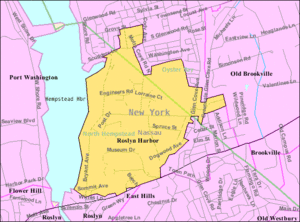
Roslyn Harbor is located at 40°49′5″N 73°38′2″W / 40.81806°N 73.63389°W.
The United States Census Bureau says the village covers about 1.2 square miles (3.09 square kilometers). All of this area is land.
Roslyn Harbor's Population
| Historical population | |||
|---|---|---|---|
| Census | Pop. | %± | |
| 1940 | 303 | — | |
| 1950 | 402 | 32.7% | |
| 1960 | 925 | 130.1% | |
| 1970 | 1,125 | 21.6% | |
| 1980 | 1,129 | 0.4% | |
| 1990 | 1,114 | −1.3% | |
| 2000 | 1,023 | −8.2% | |
| 2010 | 1,051 | 2.7% | |
| 2020 | 1,067 | 1.5% | |
| U.S. Decennial Census | |||
In 2020, the village had 1,067 residents.
People of Roslyn Harbor
According to the 2010 census, there were 1,051 people living in the village. Most residents (83.63%) were White. About 11.80% were Asian, and 1.43% were African American. About 5.33% of the population was Hispanic or Latino.
In 2000, there were 1,023 people and 356 households. The average household had 2.87 people. The median age was 46 years old. The median income for a family was $150,000.
Parks and Fun in Roslyn Harbor
- Cedarmere – This used to be the home of poet William Cullen Bryant. Now it is a park and nature preserve.
- Engineers Country Club – A private club in Roslyn Harbor.
- Nassau County Museum of Art – A large art museum located in the village.
Learning in Roslyn Harbor
School Districts
Roslyn Harbor is served by two school districts. These are the Roslyn Union Free School District and the North Shore Central School District. Where students live in the village decides which school district they attend.
Library Districts
The village is also served by two library districts. These are Roslyn's library district (the Bryant Library) and the Gold Coast Library District. The library districts match the school district boundaries.
How Roslyn Harbor Works
Getting Around
Roads in the Village
Northern Boulevard (NY 25A) runs through the village. It also forms much of its southern edge.
Other important roads include Back Road, Bryant Avenue, and Glen Cove Road. The village itself takes care of about 4.75 miles (7.64 kilometers) of roads.
Train Travel
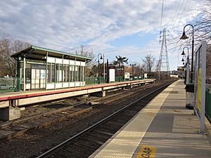
The Greenvale station is part of the Long Island Rail Road's Oyster Bay Branch. It is mostly located within Roslyn Harbor.
Bus Services
Roslyn Harbor has bus service from Nassau Inter-County Express (NICE). The bus routes that serve the village are the n20H, n21, and n27.
Village Utilities
Natural Gas
National Grid USA provides natural gas to homes and businesses in Roslyn Harbor.
Electricity
PSEG Long Island supplies electricity to all homes and businesses in the village.
Sewage System
Roslyn Harbor does not have a central sewage system. Instead, homes use cesspools and septic systems to manage wastewater.
Water Supply
Most of Roslyn Harbor gets its water from the Roslyn Water District. Smaller parts of the village are served by the Glenwood and Jericho Water Districts.
Famous People from Roslyn Harbor
- William Cullen Bryant – A famous poet and journalist. He lived at Cedarmere.
- William J. Casey – He used to be the director of the Central Intelligence Agency. His home, Mayknoll, was in Roslyn Harbor.
- Childs Frick – A scientist who studied fossils.
- Brian Koppelman – A filmmaker, writer, and podcast host.
- Gabriela Mistral – A poet from Chile who won the Nobel Prize.
- Eugene H. Nickerson – A former leader of Nassau County and a federal judge.
- Aaron Ward – A U.S. Navy officer who served in the Spanish–American War. He lived at Willowmere.
See also
 In Spanish: Roslyn Harbor para niños
 | George Robert Carruthers |
 | Patricia Bath |
 | Jan Ernst Matzeliger |
 | Alexander Miles |


