Russell, New York facts for kids
Quick facts for kids
Russell, New York
|
|
|---|---|

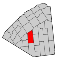
Map highlighting Russell's location within St. Lawrence County.
|
|
| Country | United States |
| State | New York |
| County | St. Lawrence |
| Area | |
| • Total | 97.29 sq mi (251.99 km2) |
| • Land | 96.49 sq mi (249.92 km2) |
| • Water | 0.31 sq mi (0.80 km2) |
| Elevation | 823 ft (251 m) |
| Population
(2020)
|
|
| • Total | 1,872 |
| • Density | 18.70/sq mi (7.22/km2) |
| Time zone | UTC-5 (Eastern (EST)) |
| • Summer (DST) | UTC-4 (EDT) |
| FIPS code | 36-64221 |
| GNIS feature ID | 0979442 |
Russell is a small town in St. Lawrence County, New York, United States. It is named after Russell Attwater, who was an early landowner. In 2020, about 1,872 people lived there.
The Town of Russell is located in the middle of St. Lawrence County. It is south of the village of Canton.
Contents
History of Russell
The land that is now Russell was bought by Russell Attwater in 1798. The first settlers arrived in 1805.
Town Formation and Changes
Russell Attwater became the first town supervisor. The town of Russell was officially formed in 1807. It was created from parts of other areas like Hopkinton, Dewitt, Ballybean, and Sarahsburg.
Over the years, parts of Russell were used to create other towns. Some land was taken to form the Town of Fowler in 1813 and 1816. More land helped form the towns of Rossie (1813), Pierrepont (1818), and Fine (1849).
Russell's Role in the War of 1812
During the War of 1812, Russell had an arsenal. An arsenal is a place where weapons and ammunition are stored. This arsenal was near Russell village. It was sold in 1865 and later used as a school. Sadly, the arsenal was destroyed by fire in 1945.
Historic Buildings
The Russell Town Hall is an important building. It was added to the National Register of Historic Places in 1996. This means it's recognized as a place with special historical value.
Famous People from Russell
Russell is the birthplace of a few notable individuals:
- Seymour H. Knox I was a successful businessman. He was born in Russell and later became famous in Buffalo, New York.
- Seymour M. Knox was a member of the Wisconsin State Assembly. He was also born in Russell.
Geography of Russell
Russell covers a total area of about 97.3 square miles (251.99 square kilometers). Most of this area is land, about 96.8 square miles (249.92 square kilometers). A small part, about 0.5 square miles (2.07 square kilometers), is water.
The Grasse River is an important natural feature. It flows north through the town of Russell.
Population of Russell
| Historical population | |||
|---|---|---|---|
| Census | Pop. | %± | |
| 1820 | 486 | — | |
| 1830 | 659 | 35.6% | |
| 1840 | 1,373 | 108.3% | |
| 1850 | 1,808 | 31.7% | |
| 1860 | 2,380 | 31.6% | |
| 1870 | 2,688 | 12.9% | |
| 1880 | 2,403 | −10.6% | |
| 1890 | 2,132 | −11.3% | |
| 1900 | 2,067 | −3.0% | |
| 1910 | 1,842 | −10.9% | |
| 1920 | 1,757 | −4.6% | |
| 1930 | 1,585 | −9.8% | |
| 1940 | 1,529 | −3.5% | |
| 1950 | 1,472 | −3.7% | |
| 1960 | 1,588 | 7.9% | |
| 1970 | 1,586 | −0.1% | |
| 1980 | 1,638 | 3.3% | |
| 1990 | 1,716 | 4.8% | |
| 2000 | 1,801 | 5.0% | |
| 2010 | 1,856 | 3.1% | |
| 2020 | 1,872 | 0.9% | |
| U.S. Decennial Census | |||
According to the census in 2000, there were 1,801 people living in Russell. There were 650 households, which are groups of people living together. About 482 of these were families.
The population density was about 18.6 people per square mile. This means that on average, about 18 or 19 people lived in each square mile of the town.
Age and Households
In 2000, about 39.8% of households had children under 18 living there. Most households, 59.2%, were married couples living together.
The population was spread out by age:
- 29.4% were under 18 years old.
- 7.5% were between 18 and 24.
- 30.0% were between 25 and 44.
- 23.2% were between 45 and 64.
- 9.9% were 65 years or older.
The average age in Russell was 35 years.
Places and Communities in Russell
The town of Russell has several smaller communities and locations within it. Here are some of them:
- Boyd Pond – A small lake located east of Coopers Corners.
- Clarks Corners – A spot east of Russell village on County Road 24.
- Coopers Corners – Found in the eastern part of the town, northeast of South Russell.
- Danes Corners – A location north of Russell village.
- Degrasse – A small village in the southeastern part of the town on County Road 17.
- Derbyville – A small village south of Russell village on County Road 24.
- Devils Elbow – A place along the Grasse River, northwest of Russell village.
- Enderbees Corners – Located in the northeastern part of the town where County Roads 25 and 27 meet.
- Fairbanks Corners – A location near the western town border on County Road 21.
- Fordhams Corners – A spot east of Stalbird.
- North Russell – A small village in the northeastern part of the town on County Road 25.
- Owens Corners – Located east of Clarks Corners on County Road 24 at County Road 25.
- Palmersville – A small village southeast of Russell village, close to the Grass River.
- Putnams Corners – A location north of Russell village.
- Reynolds Corners – Found in the eastern part of the town near Coopers Corners.
- Russell – This is the main village of Russell. It's by the Grasse River on County Road 17.
- Scotts Corners – A location north of Russell village.
- South Russell – A location in the center of the town on County Road 17.
- Stalbird – A small village near the western town border, southwest of Russell village.
- Van House Corners – A location in the eastern part of the town.
- Whipperwill Corners – A location south of Russell village on County Road 24.
See also
 In Spanish: Russell (Nueva York) para niños


