Russia–Ukraine border facts for kids
Quick facts for kids Russia–Ukraine border |
|
|---|---|

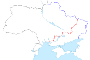
Map showing state border between Ukraine and Russia. Blue line indicates border line agreed through 2003 bilateral Treaty on the Russian–Ukrainian border. Red line indicates the claimed Russian border after the annexation of Crimea in 2014 and Russian annexation of Donetsk, Kherson, Luhansk and Zaporizhzhia oblasts in 2022.
|
|
| Characteristics | |
| Entities | |
| Length | 1925.8 km (de-jure) |
| History | |
| Established | 1991, 2003 Dissolution of the Soviet Union, Treaty on the Russian–Ukrainian border |
| Current shape | 2022 Annexation of Donetsk, Kherson, Luhansk and Zaporizhzhia oblasts |
| Notes | Russian-occupied territories of Ukraine |
The Russia–Ukraine border is the official dividing line between Russia and Ukraine. It stretches across land, connecting five regions (called oblasts) in Russia with five regions in Ukraine. Since the Russo-Ukrainian War began in 2014, the actual control of the border has changed. This means the de facto (actual) border is different from the de jure (legal) border recognized by the United Nations.
As of 2024, Russia controls a large part of Ukraine's territory. Ukraine also controls a small part of Russia. In 2016, Ukraine's border chief, Viktor Nazarenko, said Ukraine did not control about 409.3 kilometers (254.3 miles) of its border with Russia. This area was controlled by groups supported by Russia. These areas were later taken over by Russia in September 2022. Ukraine also lost control of the Kerch Strait in 2014 when Russia took over Crimea.
In 2014, Ukraine started a plan called "Project Wall". The goal was to build a strong barrier along the border to stop more Russian attacks. This project was expected to cost about 520 million US dollars and take four years. Construction began in 2015 but stopped when Russia launched a full-scale invasion in 2022.
Since 2018, Ukraine has put in place special rules for Russian citizens entering the country. On January 1, 2018, Ukraine started using biometric controls, like fingerprint scans. On March 22, 2018, former Ukrainian president Petro Poroshenko made a rule that Russian visitors had to tell Ukrainian authorities why they were traveling. Also, crossing the border illegally to harm Ukraine's interests became a crime punishable by up to three years in prison. Since November 30, 2018, Ukraine has generally banned Russian men aged 16–60 from entering, with some exceptions.
Today, only one checkpoint, Kolotylivka-Pokrovka, is open for Ukrainians to cross into Russia. It is located between Ukraine's Sumy Oblast and Russia's Belgorod Oblast. Since March 1, 2020, Ukrainian citizens need an international passport to enter Russia.
Contents
How the Border Was Formed
Early History and Soviet Times

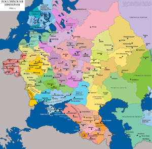
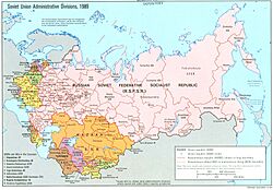
The border between Russia and Ukraine largely follows the old administrative lines from when they were parts of the Russian Empire and later the Soviet Union. The first real border setting happened in May 1918 in Kursk. After the Russian Empire fell, Ukraine tried to become an independent state.
In May 1918, Ukraine and Soviet Russia signed a ceasefire. They created a neutral zone to prevent more fighting. Peace talks began, but they disagreed on how to draw the border. Ukraine wanted to use areas where Ukrainian-speaking people lived. Russia wanted people in each town to vote. They eventually agreed to Ukraine's idea, but talks stopped because Russia seemed to be using the time for propaganda.
Later, Ukraine had more successful talks with the Don Republic. In August 1918, they agreed on a border based on old administrative divisions. Ukraine also gained some land near Mariupol.
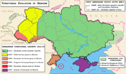
After another invasion by Soviet troops in 1919, a new border treaty was signed between the Russian SFSR and the Ukrainian SSR. In 1919, some Ukrainian territories were moved to a new Russian region. After the Soviet Union was officially formed in 1922, Ukraine claimed more land where Ukrainian speakers lived. By 1927, the administrative border was set.
Crimea's Transfer in 1954

In 1954, Nikita Khrushchev, the leader of the Soviet Union, moved the Crimea peninsula from the Russian part of the Soviet Union to the Ukrainian part. This was seen as a small, symbolic change at the time because both were part of the Soviet Union. Crimea's special self-governing status was brought back in 1991, just before the Soviet Union broke apart.
The Border Since 1991

When Ukraine became an independent country in 1991, it kept the same territory and borders as the Ukrainian SSR. However, this border was just an administrative line, not a clearly marked international boundary. Ukraine has been trying to establish a proper border ever since.
Budapest Memorandum (1994)
The Budapest Memorandum on Security Assurances was an important agreement signed in 1994. In this agreement, Russia, the United States, and the United Kingdom promised to respect Ukraine's existing borders. This was part of a deal where Ukraine gave up its nuclear weapons.
Border Treaty (2003)
Ukraine and Russia signed the Treaty on the Russian-Ukrainian border on January 28, 2003. This treaty officially defined the entire land border between the two countries. It was approved by both sides and became active in 2004. However, they did not agree on the sea border in the Azov Sea and the Kerch Strait.
A separate Russian–Ukrainian Friendship Treaty was signed in 1997. This treaty included recognizing the existing borders and prevented either country from invading the other. After Russia took over Crimea in 2014, Ukraine decided not to renew this treaty when it ended in March 2019.
Tuzla Island Dispute (2003)
In 2003, there was a disagreement over Tuzla Island in the Kerch Strait. This island is part of Ukraine. Russia argued about the legal reasons for Crimea and Tuzla being transferred to Ukraine in 1954. The main shipping routes in the Kerch Strait are near Tuzla Island and are considered Ukrainian waters. Russia wanted the border to go along the seabed, sharing the Azov Sea and Kerch Strait. This conflict was also about potential oil and gas in the area.
Russia Takes Over Crimea (2014)
Since March 2014, when Russia took over Crimea, the status of Crimea and the city of Sevastopol has been disputed. Ukraine and most other countries see Crimea as an autonomous region of Ukraine. Russia, however, considers Crimea a part of Russia. Russia also used to lease a naval base in Sevastopol, but this agreement was ended by Russia in 2014. In December 2018, Russia announced it had finished building a 60-kilometer (37-mile) barrier across the Perekop Isthmus between Ukraine and Crimea.
Rules for Russians Entering Ukraine (2018–Present)
On January 1, 2018, Ukraine started requiring biometric controls for Russians entering the country. On March 22, 2018, President Petro Poroshenko signed a rule that Russian citizens must tell Ukrainian authorities their reason for travel in advance.
On November 7, 2018, Ukraine's laws were changed. Crossing the border illegally to harm Ukraine's interests became a crime. This applies to people denied entry or Russian military members trying to cross without proper documents. Such actions can lead to imprisonment for up to three years, or even longer for repeated offenses or if violence is involved.
Since November 30, 2018, Ukraine has banned most Russian men aged 16 to 60 from entering the country. Ukraine says this is a security measure to prevent Russia from forming private armies on Ukrainian soil.
Full-Scale Russian Invasion (2022–Present)
On February 24, 2022, Russian forces crossed the border in a full-scale invasion of Ukraine. Russian troops also entered Ukraine from Belarus and the disputed Crimean Peninsula. By April 2022, Ukrainian border guards had regained control of some border crossings in the Chernihiv and Sumy regions.
On July 1, 2022, Ukraine made it mandatory for Russian citizens to apply for a visa to enter Ukraine. In the first four months of this new rule, only a few visas were issued, and very few Russian citizens entered Ukraine, mostly for humanitarian reasons.
Border Geography
The Russia-Ukraine border is about 2,295 kilometers (1,426 miles) long. This includes about 1,974 kilometers (1,227 miles) of land border and 321 kilometers (199 miles) of sea border. It stretches from the Black Sea, through the Kerch Strait and the Sea of Azov, all the way to the meeting point with Belarus in the north. This border has the most checkpoints of any border in Ukraine.
Marking the Border

A treaty to mark the border was signed in May 2010. Ukraine planned to start marking the border after this agreement was approved. However, it was not fully approved. In June 2014, Ukraine's National Security and Defense Council ordered the government to mark the border on its own, due to threats to national security during the War in Donbas.
Ukrainian Border Barrier
Starting in May 2015, Ukraine began building a strong fortified barrier along its border with Russia. This project was often called "Yatseniuk's Wall." Its main goal was to stop Russian military and hybrid warfare actions in Ukraine.
By May 2015, a wall defense system was being built in the Kharkiv region. The project was supposed to be finished by 2018, but later the State Border Guard of Ukraine expected it to be done by 2025. However, construction stopped when Russia invaded Ukraine in February 2022.
Border Checkpoints
Ukraine has many checkpoints along its border with Russia. These checkpoints are places where people and goods can officially cross the border.
Before the full-scale invasion in 2022, Ukraine had lost control of about 409.3 kilometers (254.3 miles) of its border in southeastern Ukraine. This area was controlled by groups in the Donetsk People's Republic and Luhansk People's Republic.
The number of Russian citizens crossing into Ukraine dropped significantly after 2014. In 2014, over 2.5 million Russians crossed the border, but this number almost halved in 2015. Ukrainian authorities also refused entry to many Russian citizens.
Examples of Checkpoints
- Chernihiv Oblast: Hremiach, Mykolayivka, Senkivka
- Sumy Oblast: Bachivsk, Katerynivka, Yunakivka, Seredyna-Buda, Velyka Pysarivka, Pokrovka, Hrabovske
- Kharkiv Oblast: Hoptivka, Kozacha Lopan, Pletenivka, Topoli
- Luhansk Oblast: Prosyane, Krasna Talivka, Milove
- Donetsk Oblast: Marynivka, Novoazovsk
Many border checkpoints were closed during the Russo-Ukrainian War.
Local Border Traffic
On March 16, 2015, Ukraine ended an agreement that allowed people living near the border to cross easily. Ukraine said this was for national security. Russia also temporarily stopped local border traffic in some areas. However, simplified crossings were allowed for holidays in some parts of the Luhansk region.
See also
- Borders of Russia
- Borders of Ukraine
- Russia–Ukraine relations
 | John T. Biggers |
 | Thomas Blackshear |
 | Mark Bradford |
 | Beverly Buchanan |


