
Ruth Peak facts for kids
Quick facts for kids Ruth Peak |
|
|---|---|

Northeast aspect, from Hurricane Ridge
|
|
| Highest point | |
| Elevation | 6,850 ft (2,090 m) |
| Prominence | 250 ft (76 m) |
| Isolation | 0.9 mi (1.4 km) |
| Parent peak | Mount Carrie (6,995 ft) |
| Geography | |

Ruth Peak
Location in Washington (state)

Ruth Peak
Location in the United States
|
|
| Location | Olympic National Park Clallam County, Washington, US |
| Parent range | Olympic Mountains |
| Topo map | USGS Mount Carrie |
| Geology | |
| Age of rock | Eocene |
| Climbing | |
| First ascent | 1961 |
| Easiest route | class 3 scrambling |
Ruth Peak is a tall, glaciated mountain peak in Olympic National Park. It stands at about 6,850 feet (2,088 meters) high. You can find it in Clallam County, in the state of Washington.
This mountain is the third-highest peak in the Bailey Range. The Bailey Range is a smaller part of the larger Olympic Mountains. Ruth Peak's closest taller neighbor is Mount Carrie, which is about 0.91 miles (1.46 kilometers) to the northwest. Mount Fairchild is also nearby, about 0.92 miles (1.48 kilometers) to the north.
If the weather is clear, you can see Ruth Peak from the visitor center at Hurricane Ridge. Water from the mountain flows into streams that feed the Hoh and Elwha Rivers. The first people to climb this peak were Bert Brown, Roy Etten, and Victor Nelson in 1961.
Weather and Climate Around Ruth Peak

Ruth Peak is in a special climate zone called the marine west coast climate. This type of climate is found in western North America. It helps support the Fairchild Glacier, which is on the mountain's northeast side.
Most of the weather systems that affect Ruth Peak come from the Pacific Ocean. They travel northeast towards the Olympic Mountains. When these weather systems hit the tall mountains, they are forced to rise. This causes them to drop a lot of moisture as rain or snow. This process is called orographic lift.
Because of this, the Olympic Mountains get a lot of rain and snow, especially in winter. During winter, it's often cloudy. But in summer, high-pressure systems over the Pacific Ocean bring clear skies. The best time to visit or climb Ruth Peak is usually from July to September.
How the Olympic Mountains Formed
The Olympic Mountains are made up of special kinds of rocks. These rocks include sandstone, turbidite (rock formed from underwater landslides), and basalt (a type of volcanic rock). These rocks were pushed up from the ocean floor a very long time ago, during a period called the Eocene epoch.
The mountains got their shape during the Pleistocene era. This was a time when large glaciers moved across the land many times. These glaciers carved out valleys and peaks as they advanced and then melted away.
Images for kids
-
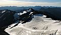
Ruth Peak and Fairchild Glacier seen from Mount Carrie
-
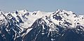
Ruth Peak (left), Mts. Fairchild and Carrie to right
-
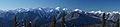
Bailey Range with Ruth Peak left of center

.jpg)
