Rutledge, Minnesota facts for kids
Quick facts for kids
Rutledge
|
|
|---|---|
| Motto(s):
"The Lonely Pine"
|
|

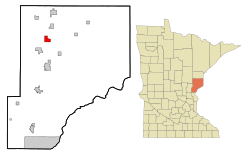
Location of the city of Rutledge
within Pine County, Minnesota |
|
| Country | United States |
| State | Minnesota |
| County | Pine |
| Incorporated | February 17, 1893 |
| Area | |
| • Total | 3.02 sq mi (7.81 km2) |
| • Land | 2.95 sq mi (7.63 km2) |
| • Water | 0.07 sq mi (0.18 km2) |
| Elevation | 1,030 ft (310 m) |
| Population
(2020)
|
|
| • Total | 212 |
| • Density | 71.96/sq mi (27.78/km2) |
| • Demonym | Rutledgevian |
| Time zone | UTC-6 (Central (CST)) |
| • Summer (DST) | UTC-5 (CDT) |
| ZIP code |
55795
(North of Pine River) 55735 (South of Pine River) |
| Area code(s) | 218 (North of Pine River) 320 (South of Pine River) |
| FIPS code | 27-56518 |
| GNIS feature ID | 2396462 |
Rutledge is a small city in Pine County, Minnesota, United States. It is located where the Kettle River and Pine River meet. In 2020, about 212 people lived there.
A main road, Pine County 61, runs through Rutledge. The Willard Munger State Trail, which is great for biking and snowmobiling, also goes through the city.
Contents
History of Rutledge
For a long time, Indigenous people lived along the Kettle River in this area. In the 1860s, a road called the Government Road (also known as Military Road) was built. It connected St. Paul, Minnesota to Superior, Wisconsin.
A bridge was built over the Kettle River at a spot called the Rock Dam. On the south side of the river, a station was set up. Stagecoaches would stop there for travelers to rest and eat. This is where the first European settlers arrived.
In 1870, the Lake Superior and Mississippi Railroad was finished in this region. A train station was built about two and a half miles upstream from the Rock Dam. It was named Kettle River Station. The community started to grow around this new station.
On February 14, 1893, the people living there voted to become an official village. Most people voted yes. The Village of Rutledge was named after Edward Rutledge, a local lumberman. He had built several mills in the area. James D. McCormack became the first Mayor of Rutledge.
Geography of Rutledge
Rutledge is a small city. The United States Census Bureau says it covers about 3.03 square miles (7.85 square kilometers). Most of this area is land, about 2.96 square miles (7.67 square kilometers). A small part, about 0.07 square miles (0.18 square kilometers), is water.
Population and People
| Historical population | |||
|---|---|---|---|
| Census | Pop. | %± | |
| 1900 | 363 | — | |
| 1910 | 89 | −75.5% | |
| 1920 | 90 | 1.1% | |
| 1930 | 95 | 5.6% | |
| 1940 | 161 | 69.5% | |
| 1950 | 163 | 1.2% | |
| 1960 | 146 | −10.4% | |
| 1970 | 123 | −15.8% | |
| 1980 | 185 | 50.4% | |
| 1990 | 152 | −17.8% | |
| 2000 | 196 | 28.9% | |
| 2010 | 229 | 16.8% | |
| 2020 | 212 | −7.4% | |
| U.S. Decennial Census | |||
Rutledge Population in 2010
In 2010, the city of Rutledge had 229 people living in it. There were 94 households, and 65 of these were families.
Most people in Rutledge were White (96.9%). A small number were African American, Native American, or from two or more races. Less than 1% of the population was Hispanic or Latino.
About 30.9% of households had children under 18 living with them. More than half of the households (54.3%) were married couples. The average household had 2.44 people.
The average age of people in Rutledge was 42.1 years old. About 21.8% of residents were under 18. Most people were between 25 and 64 years old. The city had slightly more males (51.1%) than females (48.9%).
See also
 In Spanish: Rutledge (Minnesota) para niños
 | James B. Knighten |
 | Azellia White |
 | Willa Brown |

