
Rümikon facts for kids
Quick facts for kids
Rümikon
|
||
|---|---|---|
 |
||
|
||

Rümikon
Location in Switzerland

Rümikon
Location in Canton of Aargau
|
||
| Country | Switzerland | |
| Canton | Aargau | |
| District | Zurzach | |
| Area | ||
| • Total | 2.91 km2 (1.12 sq mi) | |
| Elevation | 343 m (1,125 ft) | |
| Population
(December 2005)
|
||
| • Total | 210 | |
| • Density | 72.2/km2 (187/sq mi) | |
| Postal code |
5464
|
|
| Surrounded by | Fisibach, Hohentengen am Hochrhein (DE-BW), Mellikon, Wislikofen | |

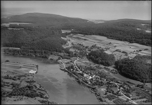
Rümikon is a small village in Switzerland. It used to be its own town, but now it's part of a bigger area called Zurzach. Rümikon is located in the Aargau region.
It's famous for an old Roman watchtower called the Sandgraben. This tower is so important that it's considered a special national treasure!
On January 1, 2022, Rümikon and several other towns joined together to form a new, larger town called Zurzach.
Contents
A Look at Rümikon's Past
Near the Rhine River, you can still find parts of two old Roman watchtowers. The name Rümikon might come from an even older village built by a group of people called the Alamanni.
We first hear about Rümikon in history books way back in 1113. At that time, a nobleman gave the village to a church leader in Wislikofen. For many years, from 1415 to 1798, Rümikon was part of a larger area called the County of Baden.
For hundreds of years, the most important job in Rümikon was fishing. In 1440, a man named John Escher sold the Rümikon farm, but he kept the fishing rights! In 2009, the local community bought these fishing rights.
Rümikon was part of a different church area until 1857, when it joined the Wislikofen church area. The local Anna chapel was built in 1710 and has been fixed up a few times since then.
In 2000, most people (about 80%) who lived in Rümikon traveled to other towns for work. A train station was built in 1876 for both Mellikon and Rümikon. Since 1995, Rümikon has its own train station right in the village.
Where is Rümikon?

Rümikon covers an area of about 2.9 square kilometers (1.1 square miles).
- About 41% of the land is used for farming.
- Almost 45% is covered by forests.
- About 8.6% has buildings or roads.
- The rest, about 6.6%, is rivers or lakes.
Most of the built-up area is for homes and roads. In the forests, a large part is dense woods, and some areas have orchards or small groups of trees. For farming, people grow crops, use land for pastures, and some areas have orchards or vineyards. All the water in Rümikon is from flowing rivers.
The village is located in the Zurzach area, right between the Rhine River and the Jura Mountains. Rümikon is a "linear village," meaning it stretches out along a road or river.
Rümikon's Coat of Arms
The village's coat of arms shows a silver salmon fish with three silver stars on a blue background.
Who Lives in Rümikon?

As of 2008, Rümikon had a population of 220 people. About 45% of the people living there were from other countries. Over the past 10 years (1997–2007), the number of people living in Rümikon went down a little.
Most people in Rümikon (about 96.5%) speak German. A smaller number of people speak Turkish or Arabic.
In 2008, there were slightly more women (52.7%) than men (47.3%) living in Rümikon. The population grew by about 7.8% in 2008.
Here's a look at the age groups in Rümikon in 2008:
- Children (0-9 years old): 8.8%
- Teenagers (10-19 years old): 11.9%
- Young adults (20-29 years old): 17.2%
- Adults (30-59 years old): 42.3%
- Seniors (60 years and older): 19.9%
In 2000, there were 87 homes in Rümikon, and on average, about 2.6 people lived in each home. In 2008, about 35.7% of all homes were single-family houses.
In the 2007 national election, the most popular political party was the SVP.
Here's how the population of Rümikon has changed over the years:
| Historical population | ||
|---|---|---|
| Year | Pop. | ±% |
| 1850 | 269 | — |
| 1900 | 199 | −26.0% |
| 1950 | 193 | −3.0% |
| 1980 | 166 | −14.0% |
| 1990 | 201 | +21.1% |
| 2000 | 227 | +12.9% |
Important Heritage Site
The Sandgraben, which is part of the old Roman defenses along the Rhine, is listed as a very important Swiss heritage site.
Working in Rümikon
As of 2007, the unemployment rate in Rümikon was 2.62%.
- About 11 people worked in farming and related businesses.
- About 24 people worked in manufacturing and construction.
- About 32 people worked in services (like shops or offices).
In 2000, 121 people lived in Rümikon, but most of them (about 81%) worked outside the village. However, 55 people traveled into Rümikon for work. There were 78 jobs in the village. Most people (64.2%) used a private car to get to work, while 13.8% used public transportation.
Religion in Rümikon
Based on the 2000 census:
- About 44.1% of people were Roman Catholic.
- About 33.5% belonged to the Swiss Reformed Church.
- A small number (about 1.76%) were part of the Christian Catholic faith.
Education
In Rümikon, about 76.3% of adults (aged 25-64) have finished high school or gone on to higher education, like university.
Getting Around
The Rümikon AG railway station is served by the Zurich S-Bahn line S36. This train line connects Bülach and Waldshut.
See also
 In Spanish: Rümikon para niños
