Fisibach facts for kids
Quick facts for kids
Fisibach
|
||
|---|---|---|
 |
||
|
||
| Country | Switzerland | |
| Canton | Aargau | |
| District | Zurzach | |
| Area | ||
| • Total | 5.77 km2 (2.23 sq mi) | |
| Elevation | 378 m (1,240 ft) | |
| Population
(Dec 2020 )
|
||
| • Total | 543 | |
| • Density | 94.11/km2 (243.7/sq mi) | |
| Postal code |
5467
|
|
| Surrounded by | Bachs (ZH), Hohentengen am Hochrhein (DE-BW), Kaiserstuhl, Oberweningen (ZH), Rümikon, Siglistorf, Weiach (ZH), Wislikofen | |
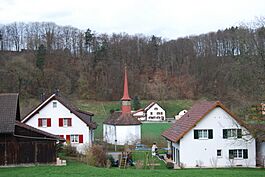
Fisibach is a small village and municipality in Switzerland. It is located in the Zurzach district, which is part of the canton of Aargau.
Contents
History of Fisibach
Fisibach has a long history! People lived here even in the Bronze Age, which was thousands of years ago. The first clear sign of a settlement was a Roman era watchtower. This tower was built along the Rhine River to keep an eye on things.
The modern village of Fisibach was first mentioned in old writings around the year 1050. Back then, it was called Fusibach. There was once a Waldhausen Castle nearby. In 1113, the owners of this castle gave a lot of land around it to St. Blaise's Abbey. However, by the 1400s, the castle was no longer used.
Another castle, called Schwarzwasserstelz Castle, stood on a rock in the Rhine River. After 1363, the Bishop of Constance owned it. Later, from 1589 to 1831, the Tschudi family from Glarus owned it. Sadly, this castle was taken down in 1875 to build the Rhine Valley Railway. Fisibach itself did not get a train station.
For a long time, the people of Fisibach were part of the Hohentengen parish (a church area). But in 1842, they joined the Kaiserstuhl parish instead. A small village chapel was built in the 1600s. For many years, farming was the main way people made a living in Fisibach, right up until the mid-1900s.
Geography of Fisibach
Fisibach covers an area of about 5.79 square kilometers (about 2.2 square miles). A big part of this land, about 43%, is used for farming. Another large part, about 46%, is covered by forests. The rest of the land, about 8.5%, has buildings or roads on it. A small amount, about 2.2%, is rivers or lakes.
Most of the forested land is covered with thick trees. For farming, about 30% of the land is used for growing crops, and nearly 13% is used for pastures where animals graze. All the water in the municipality is flowing water, like streams and rivers.
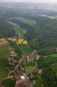
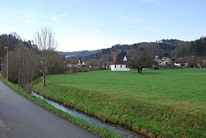
The village is located in the Zurzach district, at the end of the Fisibach valley. It is in the northeastern part of Aargau and is right next to the Canton of Zürich. Its neighbors include the municipalities of Bachs and Weiach. Fisibach is a haufendorf village, which means it grew without a clear plan, so its buildings are close together around a central area. It also includes smaller areas called hamlets, such as Burenmüli, Hägelen, and Waldhausen.
Fisibach's Coat of Arms
The blazon (official description) of Fisibach's municipal coat of arms is: Azure three Wagtails statant Azure beaked and membered Gules on a Bar Or. This means it shows three blue birds called Wagtails standing on a gold bar, all on a blue background.
People and Population
Fisibach has a population of about 383 people (as of December 2003). As of June 2009, about 15% of the people living here are from other countries. Over ten years, from 1997 to 2007, the population grew by about 6.3%. Most people in Fisibach speak German (about 91.7%). A smaller number speak Italian (1.9%) or French (1.7%).
Let's look at the age groups (as of 2008):
- About 10.7% of the population are children aged 0 to 9 years old.
- About 10.5% are teenagers aged 10 to 19.
- Adults aged 20 to 59 make up about 60.6% of the population.
- Older adults (60 and above) make up about 17.9% of the population.
In 2000, about 45% of the homes were owned by the people living in them. This means they didn't pay rent, though they might have a mortgage (a loan to buy the house). In 2008, about 41% of all homes were single-family houses.
In the 2007 Swiss federal election, the most popular political party was the SVP, which got about 46% of the votes. The next most popular parties were the CVP (18.5%), the Green Party (14.9%), and the SP (12%). About 44% of eligible voters participated in this election.
Here's how the population of Fisibach has changed over time:
| Historical population | ||
|---|---|---|
| Year | Pop. | ±% |
| 1799 | 157 | — |
| 1850 | 404 | +157.3% |
| 1900 | 246 | −39.1% |
| 1950 | 309 | +25.6% |
| 1990 | 372 | +20.4% |
| 2000 | 361 | −3.0% |
Important Heritage Sites
The Bleiche is a special place in Fisibach. It was part of the old Roman defenses along the Rhine River. It is listed as a Swiss heritage site of national significance. This means it's a very important historical place for the whole country.
Economy and Jobs
As of 2007, Fisibach had a low unemployment rate of about 2%. This means most people who wanted jobs had them.
In 2005, jobs in Fisibach were divided into three main types:
- Primary sector: About 30 people worked in farming and related businesses.
- Secondary sector: About 41 people worked in manufacturing or construction.
- Tertiary sector: About 78 people worked in services, like shops, restaurants, or offices.
In 2000, many people who lived in Fisibach worked outside the municipality (about 70%). However, some people also came into Fisibach for work. About 10.7% of working people used public transportation to get to their jobs, while 50% used a private car.
Religion in Fisibach
According to the 2000 census, about 45.7% of the people in Fisibach were Roman Catholic. About 38.8% belonged to the Swiss Reformed Church.
Education in Fisibach
Many adults in Fisibach (about 74.7% of those aged 25-64) have completed more than just basic schooling. They might have finished upper secondary education (like high school) or gone on to higher education, such as a university or a Fachhochschule (a type of college).
In the 2008/2009 school year, there were 62 students attending primary school in Fisibach. The municipality has its own kindergarten and primary school. However, children from the hamlet of Waldhausen go to school in Bachs, which is in the Canton of Zürich.
See also
 In Spanish: Fisibach para niños
 | Emma Amos |
 | Edward Mitchell Bannister |
 | Larry D. Alexander |
 | Ernie Barnes |


