
Sado, Niigata facts for kids
Quick facts for kids
Sado
佐渡市
|
|||||||||||
|---|---|---|---|---|---|---|---|---|---|---|---|
| Sado City | |||||||||||
 .jpg)  
|
|||||||||||
|
|||||||||||

Location of Sado in Niigata Prefecture
|
|||||||||||

Sado
Location in Japan
|
|||||||||||
| Country | |||||||||||
| Island | Honshu | ||||||||||
| Region | Chūbu | ||||||||||
| Prefecture | Niigata Prefecture | ||||||||||
| First official recorded | 135 AD | ||||||||||
| As city of Ryōtsu | November 3, 1954 | ||||||||||
| Town merger and new name | March 1, 2004 | ||||||||||
| Area | |||||||||||
| • Total | 855.69 km2 (330.38 sq mi) | ||||||||||
| Population
(June 1, 2023)
|
|||||||||||
| • Total | 48,195 | ||||||||||
| • Density | 56.3230/km2 (145.8758/sq mi) | ||||||||||
| Time zone | UTC+9 (Japan Standard Time) | ||||||||||
| Address | 232 Chigusa, Sado-shi, Niigata-ken | ||||||||||
| Climate | Cfa | ||||||||||
|
|||||||||||


Sado (佐渡市 (Sado-shi)) is a city in Japan. It is located on Sado Island (佐渡島 (Sado-shima/Sado-ga-shima)) in Niigata Prefecture. Since 2004, the city has covered the entire island. Sado Island is the sixth largest island in Japan. Only the four main islands and Okinawa Island are larger. As of June 1, 2023, about 48,195 people live in Sado. The total area of the city is 855.69 square kilometers (330.38 sq mi).
Contents
Sado's Past: A Look at Its History
Why Sado Was a Place of Exile

Around the 8th century, the Japanese government began to control Sado Island directly. Because the island was so far away, it became a place where important or difficult people were sent away. Being sent to Sado was a very serious punishment, almost as bad as the death penalty. People sent there usually did not expect to return home.
The first person known to be sent to Sado was a poet named Hozumi no Asomi Oyu (穂積朝臣老). He was sent to the island in 722 because he had criticized the emperor.
Later, in 1221, former Emperor Juntoku was sent to Sado. This happened after he was involved in the Jōkyū War. The emperor lived on the island for twenty years until he died. Because he was sent to Sado, he is known as Sado-no-in (佐渡院). He is buried in the Mano Goryo mausoleum on the west coast.
The Buddhist monk Nichiren lived on Sado from 1271 to 1274. He stayed near the village of Niibo. In the 17th century, Konpon Ji Temple was built where he lived. Later, Myosho Ji temple was built where he lived at the end of his exile. He also meditated where Jisso Ji Temple is today. A modern Buddhist group, Nipponzan Myohoji, built a Peace Pagoda in the city. This pagoda helps inspire people to work for world peace.
The famous Noh play writer Zeami Motokiyo was also sent to Sado in 1434. The reasons for his banishment are not fully known.
The last time someone was banished to Sado was in 1700. This was almost a thousand years after the first banishment.
The Gold Mine of Sado

Sado's economy grew quickly during the Edo period. This happened after gold was found in 1601 at Aikawa (相川). The mines became a major source of money for the Tokugawa shogunate, which was Japan's military government. However, the work conditions in the mines were very harsh.
Because there weren't enough workers, more people were sent to Sado. This time, they were not sent as punishment for a crime. From the 18th century, homeless people from Japanese cities were sent to Sado. The government hoped this would solve two problems at once. These people worked as water collectors in the mines. Their work was extremely difficult, and they often did not live very long. At its busiest, the Sado mine produced about 400 kilograms (880 lb) of gold each year. It also produced some silver. The small town of Aikawa quickly grew to about 100,000 people. The mine finally closed in 1989.
How Outside Influences Shaped Sado's Culture
In feudal Japan, a new sea route called the Nishimawari naval route opened in 1672. Ogi, in the south of the island, became an important stop on this route. This route connected the Kansai area with northern Japan across the Sea of Japan.
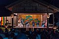
Both the people sent into exile and the ships stopping at the island greatly influenced Sado's culture. For example, Sado has many Noh theaters. Also, the local Japanese dialect and accent on Sado are different from those in Niigata.
An Emergency Landing on Sado
After World War II, on January 18, 1946, a British RAF plane called Sister Ann had to make an emergency landing on Sado Island. The local people helped the crew. They even helped build a runway so the plane could take off again. This story was made into a film called Tobe! Dakota (Fly, Dakota, Fly!). The plane from the film is now an exhibit on the island.
Sado's Geography and Climate

Sado Island has two mountain ranges that run side-by-side from southwest to northeast. Between them is a flat area called the Kuninaka plain. The Ōsado (大佐渡) range in the north is taller. Its highest point is Mount Kinpoku (金北山), which is 1,172 meters (3,845 ft) high. Other peaks include Mount Kongō, Mount Myōken, and Mount Donden. The Kosado (小佐渡) range in the south faces the Honshu coast. The highest point in Kosado is Ōjiyama (大地山) at 645 meters (2,116 ft).
The Kuninaka plain is the most populated part of the island. It opens onto Ryōtsu Bay (両津湾) on the east and Mano Bay (真野湾) on the west. The longest river, Kokufugawa (国府川), flows into Mano Bay.
The island has a very balanced shape. Lake Kamo (加茂湖), on the eastern side of Kuninaka, is a brackish lake. This means it has a mix of fresh and salt water. It is a good place for growing oysters.
Sado's Weather Patterns
Sado has a humid subtropical climate (Köppen climate classification Cfa). This means it has hot, humid summers and cold winters. It rains quite a lot throughout the year.
| Climate data for Aikawa, Sado, Niigata, 1991−2020 normals, extremes 1911−present | |||||||||||||
|---|---|---|---|---|---|---|---|---|---|---|---|---|---|
| Month | Jan | Feb | Mar | Apr | May | Jun | Jul | Aug | Sep | Oct | Nov | Dec | Year |
| Record high °C (°F) | 17.0 (62.6) |
20.7 (69.3) |
22.3 (72.1) |
28.0 (82.4) |
30.0 (86.0) |
34.1 (93.4) |
37.4 (99.3) |
38.5 (101.3) |
37.4 (99.3) |
31.5 (88.7) |
26.3 (79.3) |
22.9 (73.2) |
38.5 (101.3) |
| Mean daily maximum °C (°F) | 6.5 (43.7) |
6.7 (44.1) |
9.6 (49.3) |
14.9 (58.8) |
19.9 (67.8) |
23.3 (73.9) |
27.1 (80.8) |
29.3 (84.7) |
25.9 (78.6) |
20.5 (68.9) |
15.0 (59.0) |
9.7 (49.5) |
17.4 (63.3) |
| Daily mean °C (°F) | 4.0 (39.2) |
4.0 (39.2) |
6.5 (43.7) |
11.1 (52.0) |
15.9 (60.6) |
19.8 (67.6) |
24.0 (75.2) |
26.0 (78.8) |
22.5 (72.5) |
17.2 (63.0) |
11.8 (53.2) |
6.8 (44.2) |
14.1 (57.4) |
| Mean daily minimum °C (°F) | 1.3 (34.3) |
1.0 (33.8) |
2.9 (37.2) |
7.2 (45.0) |
12.0 (53.6) |
16.6 (61.9) |
21.3 (70.3) |
22.9 (73.2) |
19.2 (66.6) |
13.6 (56.5) |
8.2 (46.8) |
3.8 (38.8) |
10.8 (51.5) |
| Record low °C (°F) | −7.5 (18.5) |
−7.4 (18.7) |
−6.4 (20.5) |
−2.1 (28.2) |
2.5 (36.5) |
7.6 (45.7) |
12.1 (53.8) |
14.6 (58.3) |
9.5 (49.1) |
4.4 (39.9) |
−2.8 (27.0) |
−6.6 (20.1) |
−7.5 (18.5) |
| Average precipitation mm (inches) | 131.1 (5.16) |
91.6 (3.61) |
96.6 (3.80) |
94.5 (3.72) |
97.3 (3.83) |
122.5 (4.82) |
207.3 (8.16) |
137.5 (5.41) |
139.9 (5.51) |
133.1 (5.24) |
154.8 (6.09) |
175.7 (6.92) |
1,581.9 (62.27) |
| Average snowfall cm (inches) | 28 (11) |
25 (9.8) |
4 (1.6) |
0 (0) |
0 (0) |
0 (0) |
0 (0) |
0 (0) |
0 (0) |
0 (0) |
0 (0) |
9 (3.5) |
66 (25.9) |
| Average rainy days (≥ 3 mm) | 19.7 | 15.3 | 14.0 | 10.3 | 9.7 | 9.0 | 10.9 | 8.7 | 10.4 | 12.3 | 16.6 | 20.9 | 157.8 |
| Average snowy days (≥ 1 cm) | 7.1 | 6.8 | 1.4 | 0 | 0 | 0 | 0 | 0 | 0 | 0 | 0 | 2.5 | 17.8 |
| Average relative humidity (%) | 69 | 68 | 66 | 67 | 72 | 78 | 81 | 77 | 73 | 69 | 68 | 69 | 71 |
| Mean monthly sunshine hours | 46.2 | 69.2 | 133.1 | 177.0 | 200.7 | 178.4 | 161.2 | 207.8 | 157.0 | 147.5 | 95.8 | 50.6 | 1,624.5 |
| Source: Japan Meteorological Agency | |||||||||||||
Sado Today: Economy and Tourism
Population Changes in Sado
| Historical population | ||
|---|---|---|
| Year | Pop. | ±% |
| 1920 | 107,351 | — |
| 1930 | 106,262 | −1.0% |
| 1940 | 109,016 | +2.6% |
| 1950 | 125,597 | +15.2% |
| 1960 | 113,296 | −9.8% |
| 1970 | 92,558 | −18.3% |
| 1980 | 84,992 | −8.2% |
| 1990 | 78,061 | −8.2% |
| 2000 | 72,173 | −7.5% |
| 2010 | 62,727 | −13.1% |
| 2020 | 51,492 | −17.9% |
Sado's population has been decreasing since 1950, when it was 125,597. As of May 1, 2017, about 55,474 people lived on the island. This trend is common in many remote parts of Japan. Younger people often move to bigger cities for more opportunities. More than one-third of Sado's population (36.3%) is over 65 years old. This is a higher percentage than the national average. The island now has fewer people than it did in the 1700s and 1800s. There are not many options for higher education on the island, so students often leave for the mainland.
How People Make a Living in Sado

Farming and fishing are very important for Sado's economy. In 2000, over 22% of workers were in farming or fishing. Another 25% worked in manufacturing and construction. Fishing is mainly done in the areas of Ryotsu and Aikawa.
Tourism was very popular in the early 1990s, with over 1.2 million visitors each year. However, the number of visitors has gone down since then. In the mid-2000s, about 650,000 people visited Sado each year.
Sado is also known for its many talented artists who create beautiful objects using Japanese bamboo weaving. These artists are famous across Japan.
Visiting Sado: What to See and Do

Sado's rich history and peaceful countryside make it a popular place to visit in Niigata Prefecture. The island has many temples and old ruins. Visitors can also enjoy outdoor activities and fresh local food.
Sado is famous as the main place for breeding the Japanese crested ibis. The last Japanese-born crested ibis died in captivity on the island in 2003. Now, birds from China are being raised in a special program in the Niibo area. These birds have been released into the wild since 2008. The first baby ibises born in the wild were seen in April 2012. The ibis is a major symbol of the island and appears on many tourist items. By June 2022, about 480 crested ibises were seen in the wild. This shows a great comeback for the species, thanks to conservation efforts.
Sado has many small, traditional local festivals. Since 1988, a big yearly arts festival called the Earth Celebration has been held. This festival is run by the taiko drum group Kodo. The group lives on the island and tours for eight months each year. In August, they invite artists from around the world to perform with them at their festival on Sado. Tickets for the three-day event are limited. Kodo usually performs alone on Friday evening. The invited guest artist plays on Saturday night. The festival ends on Sunday with a joint performance by Kodo and their guests.
The Sado tourism industry was affected by the 2004 Chūetsu earthquake. Even though the damage on the island was small, roads to Niigata Prefecture were cut off, making it harder for tourists to reach Sado.
Popular Sights to Explore
Sado offers a wide variety of places to visit.
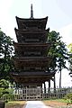
- Myōsen-ji Temple is a temple with a five-story pagoda. It is a few kilometers east of Mano. The pagoda took 30 years to build and was finished in 1825.
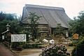
- Konpon-ji Temple is in the village of Niibo. It was built in the 17th century where Nichiren first lived during his exile on Sado.
- Rengebuji Temple near Ogi has several buildings that are important cultural properties.
- Myōshō-ji Temple is northeast of Sawata. It has a beautiful garden and was built where Nichiren lived for two years. Nearby is Jisso-ji Temple, where Nichiren used to meditate. Many pilgrims visit this temple. You can still see the pine tree where he used to hang his clothes. A tall Nichiren Memorial stands close to the temple.
- The Art and Natural History Museum of Sado is on the west coast, between Sawata and Mano. In its garden, you can see reconstructed pile houses. The first people on Sado lived in houses built on stilts.
- A traditional wooden Noh Theatre from the 19th century can be visited near Daizen Shrine in eastern Mano.
- Shukunegi is a historic area that has been preserved since the Edo Era. It was a port town on Sado. The streets were built by shipbuilders and have a wonderful old atmosphere.
Getting Around Sado
Travel by Ship
Sado Steam Ship runs two routes that connect Sado to mainland Japan.
- Joetsu – Ogi (Jetfoil, only from spring to autumn)
- Niigata – Ryotsu (Ferry and jetfoil)
Bus Services

A network of buses operates all over the island. These buses are run by Niigata Kotsu Kanko Bus.
Air Travel
Kyokushin Airways used to fly to Niigata, but stopped in September 2008. New Japan Aviation also had three or four flights daily to Sado Airport. However, service to the airport was stopped in April 2014 and has not resumed.
Notable People from Sado
- Aka Akasaka (born 1988), a manga artist and writer.
- Hachirō Arita (有田 八郎, 1884–1965), a Japanese politician and diplomat. He served as the Minister for Foreign Affairs three times. He is thought to have created the idea of the Greater East Asia Co-Prosperity Sphere.
- Makoto Asashima (浅島 誠, born 1944), a biologist.
- Hideyo Hanazumi (born 1958), a politician and the current Governor of Niigata Prefecture.
- Charles Robert Jenkins (1940–2017), a former United States Army sergeant. He went to North Korea in 1965 and was held there until 2004. He lived on Sado with his Japanese wife Hitomi Soga, who had been taken to North Korea.
- Ikki Kita (北 一輝 Kita Ikki, 1883 – 1937), whose real name was Kita Terujirō (北 輝次郎). He was a Japanese author, thinker, and political philosopher active in the early Shōwa period.
- Hitomi Nabatame (born 1976), an actress and singer.
Images for kids
-
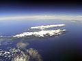
Sado island
-
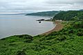
View of the coast of Sado
-
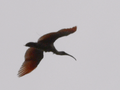
A crested ibis nearby the Crested Ibis Conservation Center on Sado Island
-
Myōsen-ji Temple
-
Konpon-ji Temple
-
Noh theatre
-
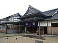
Reconstruction of the Sado bugyōsho
-
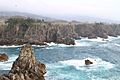
Senkakuwan
-
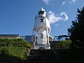
Himezaki lighthouse


.jpeg)


See also
 In Spanish: Sado (Niigata) para niños
