Saint-Émilion facts for kids
Quick facts for kids
Saint-Émilion
|
||
|---|---|---|
|
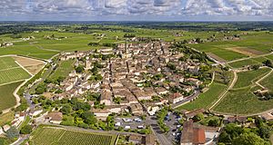
An aerial view of Saint-Émilion
|
||
|
||
| Country | France | |
| Region | Nouvelle-Aquitaine | |
| Department | Gironde | |
| Arrondissement | Libourne | |
| Canton | Les Coteaux de Dordogne | |
| Intercommunality | Saint-Émilion | |
| Area
1
|
27.02 km2 (10.43 sq mi) | |
| Time zone | UTC+01:00 (CET) | |
| • Summer (DST) | UTC+02:00 (CEST) | |
| INSEE/Postal code |
33394 /33330
|
|
| Elevation | 3–107 m (9.8–351.0 ft) (avg. 23 m or 75 ft) |
|
| 1 French Land Register data, which excludes lakes, ponds, glaciers > 1 km2 (0.386 sq mi or 247 acres) and river estuaries. | ||
| UNESCO World Heritage Site | |
|---|---|

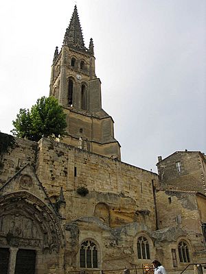
Monolithic church of Saint-Émilion and its bell tower
|
|
| Criteria | Cultural: iii, iv |
| Inscription | 1999 (23rd Session) |
| Area | 7,847 ha |
| Buffer zone | 5,101 ha |
Saint-Émilion is a charming town in south-western France. It is located in the Gironde department, which is part of the Nouvelle-Aquitaine region. This historic place is famous for its beautiful old buildings and, most importantly, its amazing wine.
Contents
Discovering Saint-Émilion's Past
Saint-Émilion has a very long history, going back to prehistoric times. It is so special that it has been named a World Heritage Site by UNESCO. This means it is recognized as a place of great importance to everyone in the world.
Ancient Roots and Roman Vines
Long ago, around the 2nd century, the Romans arrived in this area. They were the first to plant vineyards here. By the 4th century, a famous Latin poet named Ausonius was already praising the wonderful grapes grown in Saint-Émilion.
The Monk Who Gave the Town Its Name
The town was originally called Ascumbas. It got its current name from a monk named Émilion. He was a traveling confessor who came to the area in the 8th century. Monk Émilion decided to live in a hermitage, which is a small home carved right into the rock. After he settled there, other monks followed him. They were the ones who truly started the business of making wine in the area.
Where Is Saint-Émilion?
Saint-Émilion is located about 35 kilometers (22 miles) northeast of Bordeaux. It sits between two other towns, Libourne and Castillon-la-Bataille. The area is known for its rolling hills and beautiful countryside, perfect for growing grapes.
Why Is Saint-Émilion a UNESCO World Heritage Site?
Saint-Émilion became a UNESCO World Heritage Site in 1999. It was recognized for its unique history and how it shows the development of winemaking. The town's ancient churches and ruins, found along its steep, narrow streets, are also very important. The entire "Jurisdiction of Saint-Émilion" is protected, which includes the town and its surrounding vineyards.
Exploring the Monolithic Church
One of the most amazing sights in Saint-Émilion is its monolithic church. This church is carved entirely out of a single piece of rock! It is the largest underground church in Europe. You can also see its tall bell tower standing proudly above the town.
The Famous Wines of Saint-Émilion
The region around Saint-Émilion is one of the main wine-producing areas of Bordeaux. The wines from here are mostly red wines, made from Merlot and Cabernet Franc grapes. These wines are known for their rich flavors and ability to age well.
Understanding Wine Classifications
Saint-Émilion has its own special system for classifying its wines. This system helps people know the quality and reputation of different vineyards. The classifications are updated regularly, making sure that only the best wines receive the highest honors.
Images for kids
See also
 In Spanish: Saint-Émilion para niños
 | Ernest Everett Just |
 | Mary Jackson |
 | Emmett Chappelle |
 | Marie Maynard Daly |


