
Sakado, Saitama facts for kids
Quick facts for kids
Sakado
坂戸市
|
|||
|---|---|---|---|

Sakado city hall
|
|||
|
|||

Location of Sakado in Saitama Prefecture
|
|||

Sakado
Location in Japan
|
|||
| Country | Japan | ||
| Region | Kantō | ||
| Prefecture | Saitama | ||
| Area | |||
| • Total | 41.02 km2 (15.84 sq mi) | ||
| Population
(January 2021)
|
|||
| • Total | 100,612 | ||
| • Density | 2,452.75/km2 (6,352.6/sq mi) | ||
| Time zone | UTC+9 (Japan Standard Time) | ||
| - Tree | Sakura | ||
| - Flower | Satsuki azalea | ||
| Phone number | 049-283-1331 | ||
| Address | 1-1-1 Chiyoda, Sakado-shi, Saitama-ken 350-0292 | ||


Sakado (坂戸市, Sakado-shi) is a city in Saitama Prefecture, Japan. As of January 2021, about 100,612 people lived there in 46,735 homes. The city covers an area of 41.02 square kilometers. This means there are about 2500 people per square kilometer.
Contents
- Exploring Sakado's Location and Surroundings
- Population Changes in Sakado Over Time
- A Look at Sakado's Past
- How Sakado's Economy Works
- Learning and Education in Sakado
- Getting Around Sakado: Transportation Guide
- Sakado's International Connections
- Meet Sakacchi: Sakado's City Mascot
- Fun Places to Visit in Sakado
- Famous People from Sakado
- Images for kids
- See also
Exploring Sakado's Location and Surroundings
Sakado is located in the middle of Saitama Prefecture. It is about 40 kilometers away from central Tokyo. The land in Sakado is mostly flat. The Koma River flows through the city from the southwest to the northeast.
Neighboring Cities and Towns
Sakado shares its borders with several other places in Saitama Prefecture. These include:
- Hatoyama
- Hidaka
- Higashimatsuyama
- Kawagoe
- Kawajima
- Moroyama
- Tsurugashima
Understanding Sakado's Climate
Sakado has a humid subtropical climate. This type of climate means it has warm summers and cool winters. There is usually little to no snowfall. The average temperature each year in Sakado is 14.6°C. The city gets about 1382 mm of rain every year. September is usually the wettest month. The warmest month is August, with temperatures around 26.5°C. January is the coldest month, with temperatures around 3.7°C.
Population Changes in Sakado Over Time
The number of people living in Sakado grew very quickly in the late 1900s. This happened because new towns were built. Since then, the population has stayed about the same.
| Historical population | ||
|---|---|---|
| Year | Pop. | ±% |
| 1950 | 23,682 | — |
| 1960 | 23,569 | −0.5% |
| 1970 | 27,308 | +15.9% |
| 1980 | 77,335 | +183.2% |
| 1990 | 95,740 | +23.8% |
| 2000 | 97,381 | +1.7% |
| 2010 | 101,700 | +4.4% |
| 2020 | 100,275 | −1.4% |
A Look at Sakado's Past
Sakado was once a post station called Sakado-juku. This was a stop on the Nikkō Wakiōkan highway. This highway connected Hachiōji with Nikkō starting from the Muromachi period. In the late Edo period and early Meiji period, the area was known for making silk.
The village of Sakado was officially created on April 1, 1889. It was part of Iruma District, Saitama. On December 10, 1896, it became a city. Later, on July 1, 1954, Sakado grew by adding the nearby villages of Miyoshino, Issai, Oya, and Suguro. Finally, on September 1, 1976, Sakado was officially made a city.
How Sakado's Economy Works
Sakado is an important place for business in its region. It has some light manufacturing and makes precision parts. Food processing is also a part of its economy. More and more, Sakado is becoming a commuter town. This means many people who live in Sakado travel to Tokyo Metropolis for work.
Learning and Education in Sakado
Sakado has many schools and universities.
Universities in Sakado
- Josai University
- Kagawa Nutrition University
- Meikai University School of Dentistry
High Schools in Sakado
- Sakado High School
- Sakado Nishi High School
- Senior High School at Sakado, University of Tsukuba
- Yamamura International High School
Elementary and Junior High Schools
The city government runs 11 public elementary schools and seven public middle schools. The Saitama Prefectural Board of Education operates two public high schools. There is also one national high school and one private high school. The prefecture also has a special education school for students with disabilities.
Getting Around Sakado: Transportation Guide
Sakado has good transportation options, including trains and highways.
Train Lines and Stations
![]() Tōbu Railway - Tōbu Tōjō Line
Tōbu Railway - Tōbu Tōjō Line
- Wakaba - Sakado – Kita-Sakado
![]() Tōbu Railway - Tobu Ogose Line
Tōbu Railway - Tobu Ogose Line
- Nishi-Ōya
Major Highways
 Ken-Ō Expressway – Sakado Interchange
 Kan-etsu Expressway – Sakado-Nishi Smart Interchange
 National Route 1
Sakado's International Connections
Sakado has a special friendship with a city in the United States.
 Dothan, Alabama, United States, since March 1988
Meet Sakacchi: Sakado's City Mascot
The city has a fun mascot named "Sakacchi" (さかっち). This mascot was created in 2006. It marked 30 years since Sakado became a city.
Fun Places to Visit in Sakado
There are interesting places and events in Sakado.
- Xien Ten Gong, the largest Taoist temple in Japan, is located in Sakado.
- The Yosakoi festival is held every August in Sakado. It has been happening since 2001.
Famous People from Sakado
Some well-known people come from Sakado:
- Takaki Horigome, musician, Kirinji
- Yasuyuki Horigome, musician, Kirinji
Images for kids
-
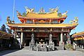
Sakado Xien Ten Gong

See also
 In Spanish: Sakado para niños
