Sanborn, Wisconsin facts for kids
Quick facts for kids
Sanborn, Wisconsin
|
|
|---|---|

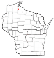
Location of Sanborn, Wisconsin
|
|
| Country | |
| State | |
| County | Ashland |
| Founded | March 23, 1899 |
| Named for | Senator A.W. Sanborn |
| Area | |
| • Total | 161.0 sq mi (416.9 km2) |
| • Land | 157.1 sq mi (406.9 km2) |
| • Water | 3.9 sq mi (10.0 km2) |
| Elevation | 735 ft (224 m) |
| Population
(2020)
|
|
| • Total | 1,381 |
| • Density | 8.579/sq mi (3.3125/km2) |
| Time zone | UTC-6 (Central (CST)) |
| • Summer (DST) | UTC-5 (CDT) |
| Area code(s) | 715 & 534 |
| FIPS code | 55-71350 |
| GNIS feature ID | 1584096 |
Sanborn is a town in Ashland County, Wisconsin. In 2020, about 1,381 people lived there.
Sanborn is home to several small communities. These include Bayfront, Birch, Birch Hill, Diaperville, Franks Field, New Odanah, Odanah, and Sedgwick. Long Island, which is one of the Apostle Islands, is also part of the town.
The entire town of Sanborn is located within the Bad River Reservation. This is the land of the Bad River Band of the Lake Superior Tribe of Chippewa Indians.
Contents
Sanborn's Story: How It Began
The town of Sanborn was officially created on March 23, 1899. It is believed to be named after Senator Albert W. Sanborn. He was a member of the Wisconsin State Senate and owned a lot of land in the area.
Exploring Sanborn's Geography
Sanborn is located in northern Ashland County. It sits right along the shore of Lake Superior.
Nearby Towns and Waterways
To the west, Sanborn borders the city of Ashland and the town of Gingles. To the west and south, it borders the town of White River. The towns of Ashland and Morse are to the south. To the east, you'll find the towns of Gurney and Saxon in Iron County. North of Sanborn, in Lake Superior, is the town of La Pointe, which covers the Apostle Islands.
The Bad River flows through Sanborn. It moves from south to north and empties into Lake Superior. This happens northeast of the community of Odanah. U.S. Route 2 is a main road that goes through the town. It leads west to downtown Ashland and east to Ironwood, Michigan.
Land and Water Area
The United States Census Bureau says that Sanborn covers a total area of about 416.9 square kilometers (160.9 square miles). Most of this is land, about 406.9 square kilometers (157.1 square miles). The rest, about 10.0 square kilometers (3.9 square miles), is water. This means about 2.40% of the town's area is water.
People of Sanborn: Demographics
Let's look at the people who live in Sanborn, based on the census from 2000.
Population and Households
In 2000, there were 1,272 people living in Sanborn. These people lived in 428 households, and 321 of these were families. The population density was about 3.1 people per square kilometer (8.1 people per square mile). There were 531 housing units, which are places where people live.
Diversity in Sanborn
The people in Sanborn come from different backgrounds. In 2000, about 12.97% of the people were White. A large part, 84.51%, were Native American. A small number were Asian (0.08%) or from other races (0.16%). About 2.28% of the people were from two or more races. Also, 3.22% of the population identified as Hispanic or Latino.
Family Life and Age Groups
Out of the 428 households, 43.0% had children under 18 living with them. About 32.5% were married couples living together. In 30.6% of households, a female was the head of the house with no husband present. About 24.8% were not families.
About 21.0% of all households were made up of individuals living alone. And 6.5% of these had someone aged 65 or older living by themselves. The average household had 2.97 people, and the average family had 3.39 people.
The population in Sanborn was spread out by age. About 38.8% were under 18 years old. About 7.6% were between 18 and 24. A larger group, 28.0%, was between 25 and 44. Those aged 45 to 64 made up 19.9%. And 5.7% of the population was 65 years old or older. The average age in Sanborn was 29 years. For every 100 females, there were about 98.8 males. For every 100 females aged 18 and over, there were about 86.8 males.
Income and Poverty
In 2000, the average income for a household in Sanborn was $26,711. For families, the average income was $27,625. Males earned an average of $25,150, while females earned $20,272. The average income per person in the town was $11,664.
About 23.7% of families and 27.4% of the total population lived below the poverty line. This included 40.8% of those under 18 years old and 5.9% of those aged 65 or older.
See also
In Spanish: Sanborn (Wisconsin) para niños
 | James Van Der Zee |
 | Alma Thomas |
 | Ellis Wilson |
 | Margaret Taylor-Burroughs |

