Saskatchewan River Delta facts for kids
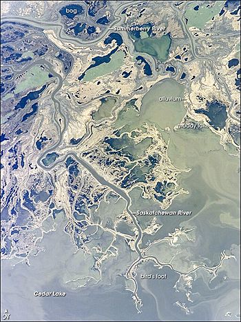
The Saskatchewan River Delta (SRD) is a huge area of land formed by a river. It sits right on the border between Saskatchewan and Manitoba in central Canada. This delta ends at Cedar Lake in Manitoba. It's mostly made up of different kinds of wetlands, shallow lakes, and old or active river channels. These channels are often lined by natural banks called levees, which have forests growing on them.
About 65% of the delta is covered by wetlands with plants. More than a third of these are special wetlands called fens and bogs, which create peat. The SRD has two main parts: a western part and an eastern part. A large ridge of land called a moraine (The Pas Moraine) separates them. This moraine was left behind by a huge ice sheet during the last Ice Age. These two parts are often called the "upper delta" and "lower delta." Together, they cover about 10,000 square kilometers (about 3,860 square miles). This makes the SRD one of the biggest active inland deltas in North America. The wide wetlands in the upper delta in Saskatchewan are sometimes known as the Cumberland Marshes. About 5% of the delta has been drained for farming. This happened after studies in the 1950s showed it might be possible.
The SRD gets most of its water from the Saskatchewan River. This river's basin stretches west to the continental divide. It includes the eastern slopes of the Canadian Rocky Mountains and much of the high plains in southern Alberta and Saskatchewan. The Saskatchewan River officially starts where its two main branches meet: the North Saskatchewan River and the South Saskatchewan River. This meeting point is about 175 kilometers (109 miles) upstream from the start of the SRD. About 80% of the water flowing into the delta comes from the Saskatchewan River. The other 20% comes from smaller streams that join the SRD at its edges. These include the Torch, Mossy, Grassberry, Sturgeon-Weir, Carrot, and Pasquia Rivers.
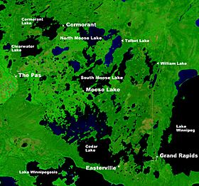
Most of the SRD is empty of people. However, about 15,000 people live in small communities around its edges. About two-thirds of these people are Metis and First Nations peoples. The other third are Euro-Canadian. Important communities include The Pas, Moose Lake, and Cormorant in Manitoba. In Saskatchewan, they include Cumberland House, Red Earth, and Shoal Lake. More than half of the delta's population lives in and near The Pas. This town is located on The Pas Moraine, between the upper and lower deltas.
How the Delta Formed and Its Human Story
Like all deltas, the SRD was created when rivers dropped sediment (like sand and mud) into a body of water. The SRD started forming about 10,000 to 11,000 years ago. This was when the Saskatchewan River flowed into the western side of a huge ancient lake called Glacial Lake Agassiz. This lake was formed by melting ice from the Laurentide Ice Sheet as it slowly moved away.
The delta grew eastward as the land rose after the ice melted, making the lake shallower. Eventually, the older The Pas Moraine became visible about 8,200 to 8,700 years ago. The Saskatchewan River then cut a path through this moraine. This created a flow-through system and started the lower delta. Both the upper and lower parts of the SRD have continued to grow until today. Now, most of the growth happens as the lower delta expands into Cedar Lake, which is a leftover part of Glacial Lake Agassiz. The delta of the Mossy River at Cumberland Lake also continues to grow.
As the SRD grew over time, the main channels of the Saskatchewan River often changed their paths. This is a normal part of how deltas develop. In the upper delta alone, the river has changed its main course at least nine times in the last 5,400 years. You can still see parts of these old, abandoned channels scattered across the delta today. The most recent big change started in the 1870s. This had a huge impact on the land and nature in the northwest part of the delta. For example, Cumberland Lake, the largest lake in the SRD, became much shallower. Before this change, it was over 6 meters (20 feet) deep. Now, it's less than 1.5 meters (5 feet) deep on average. This happened because sediment filled it in after the river changed course.
The 1870s event also made it hard for steamboats to travel on the Saskatchewan River in the late 1800s and early 1900s. The river's new paths were difficult to navigate. We don't know as much about how the lower delta developed and changed over time. However, aerial photos and satellite images clearly show signs of many old river channels.
The SRD has a long history of people living there before Europeans arrived. It was a very important travel route and meeting place for Indigenous peoples. The Saskatchewan River is a major east-west river. It connects the Rocky Mountains to the Atlantic Ocean (through Hudson Bay, Lake Winnipeg, and the Nelson River). Because of this, the SRD saw a lot of traffic in the 18th and 19th centuries. This included European explorers, fur traders, and merchants. Cumberland House was set up in 1774. It is now the oldest settlement in Saskatchewan that has been lived in continuously. It was a major meeting point for the fur-trading routes. These routes were developed by the British-based Hudson's Bay Company and the Montreal-based North West Company.
Amazing Wildlife and Plants
The mix of different wetlands, streams, lakes, and forests makes the Saskatchewan River Delta one of Canada's best places for wildlife. It has a huge number and variety of animals. This includes large mammals like moose, elk, and black bears. There are also many fur-bearing animals such as muskrats, beavers, and otters. Fish, waterfowl, and other birds also thrive here. Many of these animals are very important to the local Indigenous peoples. They rely on fishing, hunting, and trapping for their way of life. Hunting and sport fishing also bring in tourists, which helps the local economy.
Scientists have found 231 types of vascular plants and 14 types of mosses (bryophytes) in the upper SRD. Other experts have found over 50 types of water plants in the wetlands. The variety of animals with backbones is also impressive. There are over 200 kinds of birds that breed here, 43 types of mammals, 48 types of fish, and 6 types of amphibians and reptiles. Two species are especially important: the Lake Sturgeon and the Yellow Rail. The Committee on the Status of Endangered Wildlife in Canada (COSEWIC) lists the Lake Sturgeon as an Endangered Species. The Yellow Rail is listed as a Species of Concern. The Lake Sturgeon is also being considered for protection under Canada's federal Species at Risk Act (SARA).
The delta is a special place for birds and is named a Canadian Important Bird Area. It's important globally because so many waterfowl gather here. About half a million waterfowl breed in the SRD each year. The delta also serves as a vital resting spot in spring and fall for waterfowl and other waterbirds. These birds travel to and from the northern boreal and arctic regions. This includes tundra swans, snow geese, and Canada geese.
Because the SRD is so important for animals that live in water and have fur, people have managed the marshes for a long time. This work, mainly for muskrats, started in the 1930s. The Hudson's Bay Company began the Cumberland Marshes project near Cumberland House in Saskatchewan. Other groups, like Tom Lamb and the government, did similar work in Manitoba. Ducks Unlimited Canada (DUC), a non-profit group that protects nature, also started wetland projects in the 1940s. Even bigger projects happened in the 1960s and 70s. This was after hydroelectric dams were built both upstream and downstream of the delta. More recently, new management projects have been started. This is because people expect the natural habitats to continue to change. DUC currently manages about 3,000 square kilometers (1,158 square miles) of wetlands in the SRD. They do this through agreements with the two provincial governments, with help from local groups.
Challenges for the Delta
The SRD's natural environment is greatly affected by two large hydroelectric power dams. These dams were built in the 1960s. One is downstream of the delta at the outlet of Cedar Lake (Grand Rapids dam in Manitoba). The other is on the Saskatchewan River, 25 kilometers (15.5 miles) upstream of the delta (E.B. Campbell dam in Saskatchewan).
The Grand Rapids dam raised the water level of Cedar Lake by 3.5 meters (11.5 feet). This changed water levels in about 2,500 square kilometers (965 square miles) of the lower delta. It also made the open water area of Cedar Lake much bigger, to about 3,500 square kilometers (1,351 square miles). Lake levels usually go up and down by 1.5 to 2 meters (5 to 6.5 feet) each year. This depends on how much power is needed and how much water flows seasonally. After the Grand Rapids project was built, the Manitoba government named parts of the SRD as Wildlife Management Areas. This was to recognize the environmental impacts and help make up for lost habitats upstream of the dam.
Most of the water that goes into the SRD passes through the E.B. Campbell dam. This dam traps almost all the sediment that the river carries into the reservoir (Tobin Lake). It also changes the natural ups and downs of water flow. This means that the normally high flows in spring and summer are much smaller. When sediment is trapped by the dam, it causes the river channels downstream to become wider. It also means less sediment, which carries important nutrients, reaches the delta's ecosystem. Also, stopping the yearly high water flows means less flooding. This reduces how often water and nutrients are refreshed in the delta's wetlands.
The reduction of peak flows to the delta is made worse by the Gardiner dam on the South Saskatchewan River. The lake behind this dam, Lake Diefenbaker, is almost five times larger than Tobin Lake. This means it has an even bigger impact on how water flows in the SRD. The other main river that feeds the delta, the North Saskatchewan River, is not affected much by dams.
Records for the Saskatchewan River at The Pas show that the average amount of water flowing each year has dropped by about 25-30% since 1913. This drop is largely due to water being used upstream. This is especially true for irrigation projects in the South Saskatchewan River basin. Water use there has grown a lot over the same time. A long-term problem for the SRD's wetland ecosystem is the chance of water flows continuing to decrease. This could happen as populations grow and more water is needed in the future. Also, climate change in the Saskatchewan River Basin will have an impact on the SRD, but we don't know exactly what that impact will be yet.
Even though farming only affects a small part of the SRD right now, mostly near the Carrot River west of The Pas, it is slowly expanding. This happens in areas where wetlands have been drained. In the early 1980s, there was interest in expanding farming north from the Carrot River in the east-central part of the upper delta. However, no such project has started yet.
Many different levels of government (provincial and federal) are responsible for the Saskatchewan River and the SRD. Because of this, there is growing worry that decisions about managing the delta's resources will become harder to coordinate. This is especially true as environmental problems, like less water, increase. Also, Indigenous communities are becoming more interested in being involved in these decisions. This means that more teamwork and planning will be needed in the future.
 | John T. Biggers |
 | Thomas Blackshear |
 | Mark Bradford |
 | Beverly Buchanan |


