Savage, Minnesota facts for kids
Quick facts for kids
Savage
Hamilton,
Glendale |
||
|---|---|---|
|
City
|
||
|
||

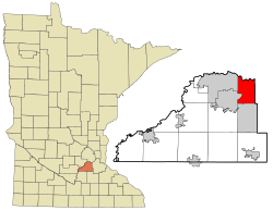
Location of the city of Savage
within Scott County, Minnesota |
||
| Country | United States | |
| State | Minnesota | |
| County | Scott | |
| Founded | 1852 | |
| Incorporated | 1892 | |
| Area | ||
| • City | 16.42 sq mi (42.53 km2) | |
| • Land | 15.60 sq mi (40.41 km2) | |
| • Water | 0.82 sq mi (2.11 km2) 4.98% | |
| Elevation | 889 ft (271 m) | |
| Population
(2020)
|
||
| • City | 32,465 | |
| • Estimate
(2022)
|
32,893 | |
| • Density | 2,080.69/sq mi (803.35/km2) | |
| • Metro | 3,690,512 | |
| Time zone | UTC−6 (Central) | |
| • Summer (DST) | UTC−5 (CDT) | |
| ZIP code |
55378
|
|
| Area code(s) | 952 | |
| FIPS code | 27-58738 | |
| GNIS feature ID | 2396543 | |
Savage is a city in Scott County, Minnesota. It is a suburb located about 15 miles (24 km) south of downtown Minneapolis. Savage is on the south bank of the Minnesota River. This area is often called South of the River.
In 2020, the city had a population of 32,465 people. Major roads like Minnesota State Highway 13 and County Road 42 run through Savage. Interstate 35W and U.S. Highway 169 are also nearby.
Savage was once a port for shipbuilding. Today, it is a growing community where many people live and work. It has many industrial and manufacturing jobs. Parts of the Minnesota Valley National Wildlife Refuge and Murphy-Hanrehan Park Reserve are within the city limits.
The city was first named Hamilton. It was later renamed Savage after Marion Willis Savage. He owned and trained a famous racing horse named Dan Patch.
Contents
History of Savage
Early Days and Settlements
In the 1600s, French fur traders and explorers came to the Minnesota River valley. After 1750, the Mdewakanton Dakota people settled near what is now Black Dog Lake. The Dakota used the Minnesota River valley for fishing, hunting, boating, and camping.
In 1852, traders set up a small post where the Credit River meets the Minnesota River. William Byrne arrived soon after. He came from Ireland and had lived in Hamilton, Ontario, Canada. He and other Irish and Scottish settlers built Hamilton Landing. This was a port for boats, named after the city in Canada. The town officially became the village of Hamilton in 1892.
Growth and New Names
The railway line reached Hamilton in 1865. In 1866, the town got its own post office. Hamilton became an important center for trade and services. This was because of the Credit River, Minnesota River, wagon trails, and the railway.
The post office was later renamed Glendale Post Station in 1894. Glendale Township was formed to the west of Hamilton. In 1969, Glendale joined with Savage. The original part of Savage's downtown, about 17 blocks, is still along Highway 13 (Minnesota).
The Dan Patch Era
In 1902, a businessman from Minneapolis, Marion Willis Savage, bought a racing horse named Dan Patch. He trained and raced Dan Patch at his farm in Hamilton. Dan Patch became very famous for breaking speed records. This made the town more well-known.
In 1904, the townspeople decided to rename the community after Marion Willis Savage. The post office made the name change official. In 1906, Dan Patch set a world record at the Minnesota State Fair. He ran a mile in 1 minute and 55 seconds. This record was not broken for 54 years!
World War II and Beyond
During World War II, Savage was home to Camp Savage. This was a special school that taught American soldiers Japanese. The school started in 1942. It helped improve military intelligence at the time. Later, the school moved to Fort Snelling.
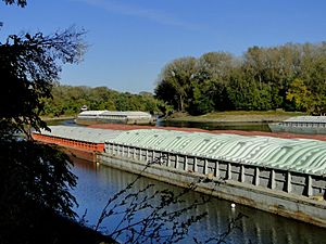
Around the same time, Cargill started building ships for the U.S. Navy. This happened at the new Meadowland Shipyard, which was renamed Port Cargill. To launch the ships, 14 miles (23 km) of the Minnesota River were made deeper. About 3,500 people worked there during busy times. They built 18 oil and gas carriers and 4 tugboats. After the war, the port began shipping farm products.
For a while after the war, Savage did not grow much. It was separated by the Minnesota River and did not have a direct highway connection. Also, building materials were hard to find nearby.
By the 1980s, things changed. Highway 13 was improved. The Highway 169 Bloomington Ferry Bridge was built in 1996. This bridge crosses the Minnesota River. After these changes, Savage grew quickly. It became a popular place to live with affordable land. In the early 2000s, citizens moved the old Savage Depot, built in 1880, to a new location to preserve its history.
Geography and Landscape
Savage covers an area of about 16.45 square miles (42.6 sq km). About 15.63 square miles (40.5 sq km) is land, and 0.82 square miles (2.1 sq km) is water. The northern border of the city is the Minnesota River. The Credit River, which flows into the Minnesota River, runs through Savage.
Population and People
| Historical population | |||
|---|---|---|---|
| Census | Pop. | %± | |
| 1900 | 179 | — | |
| 1910 | 271 | 51.4% | |
| 1920 | 206 | −24.0% | |
| 1930 | 214 | 3.9% | |
| 1940 | 222 | 3.7% | |
| 1950 | 389 | 75.2% | |
| 1960 | 1,094 | 181.2% | |
| 1970 | 3,611 | 230.1% | |
| 1980 | 3,954 | 9.5% | |
| 1990 | 9,606 | 142.9% | |
| 2000 | 21,115 | 119.8% | |
| 2010 | 26,911 | 27.4% | |
| 2020 | 32,465 | 20.6% | |
| 2022 (est.) | 32,893 | 22.2% | |
| U.S. Decennial Census 2020 Census |
|||
Savage Population in 2010
In 2010, Savage had 26,911 people living there. There were 9,116 households and 7,222 families. The city had about 1,722 people per square mile (665 per sq km).
Most people in Savage were White (82.6%). Other groups included African American (4.3%), Asian (8.4%), and Native American (0.4%). About 3.4% of the population was Hispanic or Latino.
Many households (47.6%) had children under 18 living with them. Most households (66.3%) were married couples. The average household had 2.95 people. The average family had 3.31 people.
The average age in Savage was 34.6 years. About 31.5% of residents were under 18. About 5.5% were 65 years or older. The city had slightly more males (50.1%) than females (49.9%).
Schools in Savage
Students in Savage attend schools in three different districts:
- Prior Lake-Savage District 719
- Burnsville-Eagan-Savage District 191
- Shakopee School District 720
Some students in the Prior Lake-Savage District go to Redtail Ridge Elementary School and Glendale Elementary School. They then go on to Prior Lake High School.
Students in the Burnsville-Eagan-Savage School District attend Harriet Bishop Elementary School, Hidden Valley Elementary School, and Eagle Ridge Middle School. They later go to Burnsville High School.
See also
 In Spanish: Savage (Minnesota) para niños
 | Sharif Bey |
 | Hale Woodruff |
 | Richmond Barthé |
 | Purvis Young |


