
Schlatt, Thurgau facts for kids
Quick facts for kids
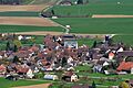
Schlatt
|
||
|---|---|---|
 |
||
|
||

Schlatt
Location in Switzerland

Schlatt
Location in Canton of Thurgau
|
||
| Country | Switzerland | |
| Canton | Thurgau | |
| District | Frauenfeld | |
| Area | ||
| • Total | 15.54 km2 (6.00 sq mi) | |
| Elevation | 416 m (1,365 ft) | |
| Population
(Dec 2020 )
|
||
| • Total | 1,814 | |
| • Density | 116.73/km2 (302.33/sq mi) | |
| Postal code |
8252
|
|
| Surrounded by | Basadingen-Schlattingen, Büsingen am Hochrhein (DE-BW), Laufen-Uhwiesen (ZH), Diessenhofen, Feuerthalen (ZH), Trüllikon (ZH), Truttikon (ZH) | |

Schlatt is a town, also called a municipality, in Switzerland. It is located in the Frauenfeld District within the canton of Thurgau. Sometimes, people call it Schlatt TG to tell it apart from other places with the same name.
Contents
History of Schlatt
Schlatt was first written about in the year 858. Back then, it was known as Slate. During the Middle Ages, the powerful House of Kyburg family, and later the House of Habsburg, controlled the area. They had a special court system called a bailiwick in Diessenhofen that oversaw Schlatt.
In the 1400s, the town of Diessenhofen became mostly independent. It took over the job of governing Schlatt until 1798. Before 858, the Abbey of St. Gall owned a lot of land here. After 858, Rheinau Abbey gained control of the land. By the 1200s, the St. Katharinental monastery owned most of the land in the village.
There was a St. Nicholas Chapel in Schlatt from 1316 to 1812. It was part of the Stammheim church area. In 1529, the Protestant Reformation led to Schlatt having its own church. However, this church later closed in 1769.
Geography and Landscape

Schlatt covers an area of about 15.5 square kilometers (6 square miles). A large part of this land, about 50%, is used for farming. Forests cover another big portion, around 37% of the area.
About 9% of Schlatt is covered by buildings and roads. A small part, about 2%, includes rivers and lakes. The rest, about 1%, is land that isn't used for farming or building.
The municipality is located on the eastern side of the Kohlfirst mountain. Schlatt was created in 1999 when two smaller areas, Mett-Oberschlatt and Unterschlatt, joined together.
Schlatt also has an interesting border along the Rhine river. It borders the German town of Büsingen am Hochrhein. This German town is special because it's an enclave, meaning it's completely surrounded by Swiss land.
Population and People
Schlatt has a population of about 1,574 people (as of 2007). Most people in Schlatt speak German, which is about 96% of the population. A small number of people also speak French or Italian.
In 2008, the population was almost evenly split between men and women. About 50.6% were male and 49.4% were female. Most people living in Schlatt are Swiss citizens. About 8.8% of the population are people from other countries.
The age groups in Schlatt show a good mix of people. In 2009, about 10% of the population were children under 9 years old. Teenagers (10-19 years old) made up about 15%. Adults between 20 and 59 years old made up a large part of the population, around 55%. Older adults and seniors (60 years and above) made up about 20% of the population.
In 2007, the construction of new homes was quite active, with about 4.5 new homes built for every 1,000 residents.
The table below shows how the population of Schlatt has changed over time:
| year | population Mett-Oberschlatt |
population Future municipal area |
|---|---|---|
| 1800 | 203 | |
| 1850 | 287 | |
| 1870 | 332 | |
| 1900 | 257 | |
| 1950 | 317 | 1,231 |
| 1980 | 939 | |
| 1990 | 326 | 1,241 |
| Year | Population | |
| 2000 | 1,485 | |
Important Heritage Sites
Schlatt is home to some important historical places. These are recognized as heritage sites of national significance.
- The old Poor Clares Monastery of Paradies in Unterschlatt.
- The Schaarenwald area, which has remains of a Bronze Age settlement, a Roman watchtower, and old military defenses.
- A special Double Farm House.
The entire small village, or hamlet, of Dickihof and the Paradies Monastery are also part of the Inventory of Swiss Heritage Sites. This means they are important to Swiss history and culture.
Economy and Jobs
In 2007, Schlatt had a very low unemployment rate of 1.55%. This means most people who wanted to work had jobs.
In 2005, many people worked in different types of jobs:
- About 107 people worked in the primary economic sector. This includes jobs like farming and forestry. There were about 36 businesses in this area.
- About 145 people worked in the secondary sector. This includes jobs in manufacturing and construction. There were 29 businesses in this area.
- About 209 people worked in the tertiary sector. This includes jobs in services, like shops, offices, and healthcare. There were 51 businesses in this area.
Many people who live in Schlatt travel to other towns for work. In 2000, about 52% of residents worked outside Schlatt. At the same time, about 221 people traveled into Schlatt to work. Most people used a private car to get to work, while some used public transportation.
Religion in Schlatt
Based on information from the year 2000, most people in Schlatt belong to one of two main Christian groups:
- About 17.6% of the population were Roman Catholic.
- About 62.2% belonged to the Swiss Reformed Church.
- A smaller number of people belonged to the Orthodox Church or other Christian churches.
Education Opportunities
Education is important in Schlatt. About 78% of adults (between 25 and 64 years old) have completed more than just basic schooling. This means they have either finished upper secondary education (like high school) or gone on to higher education, such as a university or a specialized college (called a Fachhochschule).
Images for kids
-
Schlatt, Switzerland
See also
 In Spanish: Schlatt (Turgovia) para niños
