
Selah, Washington facts for kids
Quick facts for kids
Selah, Washington
|
|
|---|---|

Location of Selah, Washington
|
|
| Country | United States |
| State | Washington |
| County | Yakima |
| Founded | 1871 |
| Incorporated | March 17, 1919 |
| Government | |
| • Type | Mayor–council |
| • Body | City council |
| Area | |
| • Total | 4.64 sq mi (12.01 km2) |
| • Land | 4.58 sq mi (11.86 km2) |
| • Water | 0.06 sq mi (0.15 km2) |
| Elevation | 1,119 ft (341 m) |
| Population
(2020)
|
|
| • Total | 8,153 |
| • Estimate
(2021)
|
8,208 |
| • Density | 1,765.34/sq mi (681.62/km2) |
| Time zone | UTC-8 (PST) |
| • Summer (DST) | UTC-7 (PDT) |
| ZIP code |
98942
|
| Area code | 509 |
| FIPS code | 53-63280 |
| GNIS feature ID | 1512655 |
Selah is a city in Yakima County, Washington. It's located just north of Yakima and is part of the larger Yakima area. In 2020, about 8,153 people lived in Selah.
Contents
History of Selah
The name Selah comes from a native word. It means 'still water' or 'smooth water'.
Selah officially became a city on March 17, 1919. A company called Tree Top, which makes apple juice, has its main office and two factories in Selah. Tree Top started in 1960.
In 2004, the Yakama Tribe bought an old juicing factory. They ran it until 2010. Now, Sun-Rype owns and runs the factory. Sun-Rype is a big juice and fruit snack company from Canada. The factory still makes apple juice and other drinks.
Many fruit companies have warehouses in Selah. This is because there are many fruit orchards nearby in the Wenas Valley. Selah also has good access to train lines and roads. This makes it easy to ship fruit to markets. Selah and the Wenas Valley are becoming a "bedroom community" for the bigger city of Yakima. This means many people who work in Yakima live in Selah.
Because of the orchards and juice factories, Selah is often called "The Apple Juice Capital of the World."
Each year on Memorial Day weekend, a group called the National Audubon Society holds a campout. It's about 22 miles north of Selah. This campout is at the Hazel Wolf Bird Sanctuary. It's in the upper Wenas Valley, near Wenas, Washington.
The upper valley also has Wenas Lake. This lake stores water for farming. Wenas Creek flows from the lake through the Wenas Valley. This is where the Wenas Creek Mammoth was found. The creek flows into the Yakima River.
Geography of Selah
Selah is located at 46°39′8″N 120°32′6″W / 46.65222°N 120.53500°W.
The United States Census Bureau says the city covers about 4.52 square miles (11.71 square kilometers). Most of this area, about 4.44 square miles (11.50 square kilometers), is land. The rest, about 0.08 square miles (0.21 square kilometers), is water.
Climate in Selah
Selah has hot and dry summers. The average monthly temperature never goes above 71.6 °F (22 °C). This type of weather is called a warm-summer Mediterranean climate. On climate maps, it's shown as "Csb".
| Climate data for Selah, Washington (1991–2020 normals, extremes 1998–present) | |||||||||||||
|---|---|---|---|---|---|---|---|---|---|---|---|---|---|
| Month | Jan | Feb | Mar | Apr | May | Jun | Jul | Aug | Sep | Oct | Nov | Dec | Year |
| Record high °F (°C) | 62 (17) |
66 (19) |
79 (26) |
87 (31) |
99 (37) |
105 (41) |
109 (43) |
104 (40) |
101 (38) |
88 (31) |
70 (21) |
61 (16) |
109 (43) |
| Mean maximum °F (°C) | 53.5 (11.9) |
58.7 (14.8) |
69.0 (20.6) |
78.6 (25.9) |
89.0 (31.7) |
95.7 (35.4) |
101.6 (38.7) |
100.5 (38.1) |
92.4 (33.6) |
78.2 (25.7) |
64.5 (18.1) |
52.9 (11.6) |
102.6 (39.2) |
| Mean daily maximum °F (°C) | 37.4 (3.0) |
45.4 (7.4) |
54.2 (12.3) |
62.4 (16.9) |
71.8 (22.1) |
78.5 (25.8) |
87.8 (31.0) |
87.2 (30.7) |
78.0 (25.6) |
63.5 (17.5) |
47.8 (8.8) |
36.5 (2.5) |
62.5 (16.9) |
| Daily mean °F (°C) | 29.5 (−1.4) |
34.5 (1.4) |
41.3 (5.2) |
48.2 (9.0) |
57.2 (14.0) |
63.5 (17.5) |
70.9 (21.6) |
69.7 (20.9) |
61.0 (16.1) |
48.9 (9.4) |
37.1 (2.8) |
28.8 (−1.8) |
49.2 (9.6) |
| Mean daily minimum °F (°C) | 21.6 (−5.8) |
23.7 (−4.6) |
28.4 (−2.0) |
34.1 (1.2) |
42.7 (5.9) |
48.4 (9.1) |
54.0 (12.2) |
52.3 (11.3) |
44.0 (6.7) |
34.4 (1.3) |
26.4 (−3.1) |
21.1 (−6.1) |
35.9 (2.2) |
| Mean minimum °F (°C) | 7.8 (−13.4) |
11.7 (−11.3) |
18.6 (−7.4) |
22.9 (−5.1) |
28.7 (−1.8) |
36.9 (2.7) |
43.6 (6.4) |
42.3 (5.7) |
32.9 (0.5) |
22.3 (−5.4) |
13.7 (−10.2) |
8.0 (−13.3) |
1.4 (−17.0) |
| Record low °F (°C) | −14 (−26) |
−5 (−21) |
5 (−15) |
18 (−8) |
20 (−7) |
33 (1) |
37 (3) |
29 (−2) |
25 (−4) |
5 (−15) |
−6 (−21) |
−7 (−22) |
−14 (−26) |
| Average precipitation inches (mm) | 1.07 (27) |
0.72 (18) |
0.68 (17) |
0.65 (17) |
0.85 (22) |
0.78 (20) |
0.23 (5.8) |
0.16 (4.1) |
0.28 (7.1) |
0.73 (19) |
0.92 (23) |
1.36 (35) |
8.43 (214) |
| Average precipitation days (≥ 0.01 in) | 9.5 | 7.4 | 7.3 | 5.9 | 7.8 | 5.5 | 2.1 | 2.4 | 3.1 | 7.5 | 9.9 | 11.5 | 79.9 |
| Source: NOAA | |||||||||||||
People of Selah (Demographics)
| Historical population | |||
|---|---|---|---|
| Census | Pop. | %± | |
| 1930 | 767 | — | |
| 1940 | 1,130 | 47.3% | |
| 1950 | 2,489 | 120.3% | |
| 1960 | 2,824 | 13.5% | |
| 1970 | 3,311 | 17.2% | |
| 1980 | 4,500 | 35.9% | |
| 1990 | 5,113 | 13.6% | |
| 2000 | 6,310 | 23.4% | |
| 2010 | 7,147 | 13.3% | |
| 2020 | 8,153 | 14.1% | |
| 2021 (est.) | 8,208 | 14.8% | |
| U.S. Decennial Census 2020 Census |
|||
Selah's Population in 2010
In 2010, the census counted 7,147 people living in Selah. There were 2,658 homes, and 1,861 of these were families.
- About 85.8% of the people were White.
- 16.4% of the population was Hispanic or Latino.
- Other groups included African American (0.5%), Native American (1.3%), Asian (0.7%), and Pacific Islander (0.2%). About 3.1% were from two or more races.
In the homes:
- 42.6% had children under 18 living there.
- 47.2% were married couples.
- 17.2% were homes with a female head and no husband.
- 5.6% were homes with a male head and no wife.
- 30.0% were not families.
The average home had 2.64 people. The average family had 3.12 people.
The average age in Selah was 31.5 years old.
- 29.6% of people were under 18.
- 10.1% were 65 years or older.
- The city had slightly more females (51.8%) than males (48.2%).
Images for kids
-
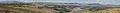
Selah, Washington viewed from Lookout Point.
See also
 In Spanish: Selah (Washington) para niños
